Digital Maps and Geospatial Data | Princeton University

Search Results Header

Search Results

Number of results to display per page

1. ALPAGE

Collection Stanford University Public content ALPAGE. ALPAGE. stanford-zp399nk6394. 2010. Noizet, Hélène, Bourlet, Caroline, Bove, Boris, Sandrine, Robert, and Costa, Laurent. ALPAGE is a geohistorical platform about Paris. Based on a work dynamic initiated in 2006 with support from the French National Research Agency (AN...
2. The Daily Telegraph war graves map of the Western Front

Image Stanford University Public content The Daily Telegraph war graves map of the Western Front. JPEG 2000. "Geographia". stanford-xx990sy0760. 1919. Gross, Alexander, 1879-1958, Daily Telegraph (London, England), and Geographia Ltd. compiled from official sources under the direction of Alexander Gross. Map of the Western Front in France and Belgium showing cemeteries, railways ...

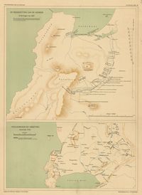
3. De nederzetting aan de Liesbeek in het begin van 1661

Princeton University Public content De nederzetting aan de Liesbeek in het begin van 1661. TIFF. 's-Gravenhage : M. Nijhoff, [1911-1933]. princeton-rn3013210. 1911. Beekman, A. A. (Anton Albert), 1854-1947. Maps showing Liesbeek in 1661 and Stellenbosch around 1700; relief shown by shading. In top of margin: Geschiedkundige atlas van Nederland. De kolo...

4. De trek der Veeboeren gedurende de 18e eeuw

Princeton University Public content De trek der Veeboeren gedurende de 18e eeuw. TIFF. 's-Gravenhage : M. Nijhoff, [1911-1933]. princeton-j38608782. 1911. Beekman, A. A. (Anton Albert), 1854-1947. Maps showing routes taken by Dutch settlers in South Africa; relief shown by shading. In top of margin: Geschiedkundige atlas van Nederland. De kol...

5. Kaapstad en omgeving omstreeks 1800

Princeton University Public content Kaapstad en omgeving omstreeks 1800. TIFF. 's-Gravenhage : M. Nijhoff, [1911-1933]. princeton-4t64gq00b. 1911. Beekman, A. A. (Anton Albert), 1854-1947. Map showing Cape Town, South Africa, Table Bay and False Bay in 1800; relief shown by shading. In top of margin: Geschiedkundige atlas van Nederlan...

6. Ontwikkeling van de nederzetting aan de Tafelbaai

Princeton University Public content Ontwikkeling van de nederzetting aan de Tafelbaai. TIFF. 's-Gravenhage : M. Nijhoff, [1911-1933]. princeton-x920fz69p. 1911. Beekman, A. A. (Anton Albert), 1854-1947. Maps showing Cape Town, South Africa, and Table Bay, in 1660, 1693, 1767 and 1786; relief shown by shading. In top of margin: Geschiedkundige atlas...

7. Zuid-Afrika onder nederlandsch bewind

Princeton University Public content Zuid-Afrika onder nederlandsch bewind. TIFF. 's-Gravenhage : M. Nijhoff, [1911-1933]. princeton-12579v09c. 1911. Beekman, A. A. (Anton Albert), 1854-1947. Map showing routes of J. W. Janssens in 1803 and J. A. de Mist in 1803-1804; relief shown by shading. In top of margin: Geschiedkundige atlas van N...

8. Zuid-Afrika onder nederlandsch bewind

Princeton University Public content Zuid-Afrika onder nederlandsch bewind. TIFF. 's-Gravenhage : M. Nijhoff, [1911-1933]. princeton-wd375z12b. 1911. Beekman, A. A. (Anton Albert), 1854-1947. Map showing routes of A. F. Beutler in 1752 and H. Hop and J. Coetsee in 1761-1762; relief shown by shading. "De politieke grenzen zijn die van 177...

9. Zuid-Afrika onder nederlandsch bewind

Princeton University Public content Zuid-Afrika onder nederlandsch bewind. TIFF. 's-Gravenhage : M. Nijhoff, [1911-1933]. princeton-db78td86n. 1911. Beekman, A. A. (Anton Albert), 1854-1947. Map showing boundaries of Cape Colony in 1798 and 1805 and routes of Olof Bergh in 1682, Simon van der Stel in 1685-1686 and I. Schrijver in 1689; ...

10. Zuid-Afrika onder nederlandsch bewind : kolonie- en districtengrenzen in de 18de eeuw

Princeton University Public content Zuid-Afrika onder nederlandsch bewind : kolonie- en districtengrenzen in de 18de eeuw. TIFF. 's-Gravenhage : M. Nijhoff, [1911-1933]. princeton-8k71nj92g. 1911. Beekman, A. A. (Anton Albert), 1854-1947. Map showing colonial boundaries in 1750 and 1798; relief shown by shading. In top of margin: Geschiedkundige atlas van Nederland. De koloniën, bla...