Digital Maps and Geospatial Data | Princeton University

latin america census costa rica Remove constraint latin america census costa rica

Search Results Header

Search Results

Number of results to display per page

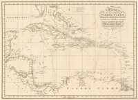
1. 't Noorder deel van WEST-INDIEN

Image Stanford University Public content 't Noorder deel van WEST-INDIEN. JPEG 2000. stanford-rz818vx8201. 1643. Goos, Abraham. With “Fol 65” (top left). Issued in: West-Indische Spieghel / Athanasium Inga. -- Amsterdam, 1624. With “Fol 51” (top left). Issued in: Journalen v...

2. 112th Congressional Boundaries USA 2011

Polygon Tufts University Public content 112th Congressional Boundaries USA 2011. Shapefile. U.S. Census Bureau. tufts-uscongdistrict11. 2011. This polygon dataset represents 112th congressional boundaries in the United States. The 112th Congressional District Boundaries data set contains ...

3. 1990 Census Roads - San Francisco Bay Area, California

Line Stanford University Public content 1990 Census Roads - San Francisco Bay Area, California. Shapefile. California. Metropolitan Transportation Commission. stanford-hp348jr8547. 1990. California. Metropolitan Transportation Commission. This line shapefile contains primary and secondary roads for the San Francosco Bay Area in California. Primary roads are generally divided, limited...

4. 1:1,000,000-Scale Combined Statistical Areas, 2013

Polygon Stanford University Public content 1:1,000,000-Scale Combined Statistical Areas, 2013. Shapefile. National Atlas of the United States. stanford-mb303sh3837. 2013. National Atlas of the United States. This polygon shapefile contains combined statistical areas in the United States and Puerto Rico. Combined statistical areas consist of two or more ...

5. 1:1,000,000-Scale Core Based Statistical Areas, 2013

Polygon Stanford University Public content 1:1,000,000-Scale Core Based Statistical Areas, 2013. Shapefile. National Atlas of the United States. stanford-bn076jc5300. 2013. National Atlas of the United States. This polygon shapefile contains core based statistical areas in the United States and Puerto Rico. The map layer was created from the CENSUS 2010 T...

6. 1:1,000,000-Scale County Boundaries of the United States, 2014

Polygon Stanford University Public content 1:1,000,000-Scale County Boundaries of the United States, 2014. Shapefile. Geological Survey (U.S.). stanford-wg010mf7692. 2014. Geological Survey (U.S.). This polygon shapefile contains the county boundaries of the United States, Puerto Rico, and the U.S. Virgin Islands, by showing the counties as ar...

7. 1:1,000,000-Scale National Boundaries of the United States, 2014

Polygon Stanford University Public content 1:1,000,000-Scale National Boundaries of the United States, 2014. Shapefile. Geological Survey (U.S.). stanford-hb541mt8292. 2014. Geological Survey (U.S.). This polygon shapefile contains the boundaries of the United States, Puerto Rico, and the U.S. Virgin Islands. The map layer was created by extract...

8. 1:1,000,000-Scale State Boundaries of the United States, 2012

Polygon Stanford University Public content 1:1,000,000-Scale State Boundaries of the United States, 2012. Shapefile. National Atlas of the United States. stanford-jv962kc4000. 2012. National Atlas of the United States. This polygon shapefile portrays the state boundaries of the United States, Puerto Rico, and the U.S. Virgin Islands. The map layer was created by e...

9. 1:1,000,000-Scale State Boundaries of the United States, 2014

Polygon Stanford University Public content 1:1,000,000-Scale State Boundaries of the United States, 2014. Shapefile. National Atlas of the United States. stanford-wj635fh1294. 2014. National Atlas of the United States. This polygon shapefile portrays the state boundaries of the United States, Puerto Rico, and the U.S. Virgin Islands. The map layer was created by e...

10. 2000 Census Traffic Analysis Zones - San Francisco Bay Area, California

Polygon Stanford University Public content 2000 Census Traffic Analysis Zones - San Francisco Bay Area, California. Shapefile. California. Metropolitan Transportation Commission. stanford-tm960wp6354. 2000. California. Metropolitan Transportation Commission and U.S. Department of Commerce, Bureau of the Census, Geography Division. This polygon shapefile contains the traffic analysis zones (TAZs) for the San Francisco Bay Area in California. These data have been clipped to the...

11. A map of the United States of Mexico

Image Stanford University Public content A map of the United States of Mexico. JPEG 2000. H.S. Tanner, No. 177 Chestnut St. ,. stanford-pn863fv0810. 1800. Tanner, Henry Schenck, 1786-1858. by H. S. Tanner. Relief shown by hachures. Latitudinal and longitudinal lines. Prime meridian: Washington. Coordinates approximate and based on Gre...

13. AMERICA

Image Stanford University Public content AMERICA. JPEG 2000. stanford-jp266yb7109. 1729. Clüver, Philipp, 1580-1622. From Eptiome Geographiae Cluverianae Nova...Phillippi Cluverii? 1727 In Latin. None found. California as an island with indented northern coast and...

14. AMERICA SEPTENTRIO= NALIS.

Image Stanford University Public content AMERICA SEPTENTRIO= NALIS. JPEG 2000. stanford-kc023qd4183. 1700. Hondius, Hendrik, 1597-1651 and Jansson, Jan, 1588-1664. Later reproduction, [unknown date], with Amstelodami, Excusum apud Iudocum et Henricum Hondium. Anno 1631. with text of manuscript appearance. With...

15. AMERICA SEPTENTRIO= NALIS.

Image Stanford University Public content AMERICA SEPTENTRIO= NALIS. JPEG 2000. stanford-cq445xf9935. 1636. Hondius, Hendrik, 1597-1651 and Jansson, Jan, 1588-1664. Issued in: Gerardi Mercatoris Atlantis Novi Pars Tertia ... -- Amsterdam, Henrici Hondij, 1636. Issued in: Le Nouveau Theatre du Monde ou Nouvel At...

16. AMERICA SEPTENTRIO= NALlS.

Image Stanford University Public content AMERICA SEPTENTRIO= NALlS. JPEG 2000. stanford-wn503xg3716. 1653. Valck, G. (Gerard), 1651 or 1652-1726 and Schenk, Pieter, approximately 1698-1775. California of Briggs type, with nearly flat northern coast. C. Blanco is point furthest north. Includes I. de Ceintas off west coast of California....

17. AMERICA SEPTENTRIONALIS divisa in suas principales partes ET STATUS seu Dominatus Regis GALLIÆ, CASTILLÆ, ANGLIÆ, SUECIÆ DANIÆ et BATAVORUM P.D. Sanson Geographum Regis Galliæ ordinarium

Image Stanford University Public content AMERICA SEPTENTRIONALIS divisa in suas principales partes ET STATUS seu Dominatus Regis GALLIÆ, CASTILLÆ, ANGLIÆ, SUECIÆ DANIÆ et BATAVORUM P.D. Sanson Geographum Regis Galliæ ordinarium. JPEG 2000. stanford-wk428tr8961. 1675. Hofmann, Johann Jacob, ǂd 17th/18th cent. California as very large island on second Sanson model, with Terra de Iesso vel Ieço and Mare de Iesso to northwest. Based on Sanson-Jaillot map of...

18. AMERICA Septentrionalis

Image Stanford University Public content AMERICA Septentrionalis. JPEG 2000. stanford-xm469xm6113. 1683. Sanson, Nicolas, 1600-1667. California as an island with flat northern coast sloping up to east. Few place names on island: C. Blanq, C. Mendocino, C. de Pinos and C. de S Luc...

19. AMERICÆ Aucta DELINEATIO

Image Stanford University Public content AMERICÆ Aucta DELINEATIO. JPEG 2000. stanford-qf555ns8242. 1745. Weigel, Christoph, 1654-1725. [1745], Mare Iesso rather than Mare de Iesso as in State 1. Much of the lettering in the oceans is in bold. In German and Latin. California as an i...

20. AMERICÆ Aucta DELINEATIO

Image Stanford University Public content AMERICÆ Aucta DELINEATIO. JPEG 2000. stanford-nj318gt4956. 1745. Weigel, Christoph, 1654-1725. Includes bibliographical references (p. xv-xvi) and indexes. In German and Latin. California as an island with indented northern coast, including n...

21. AMERICÆ Aucta DELINEATIO

Image Stanford University Public content AMERICÆ Aucta DELINEATIO. JPEG 2000. stanford-vj690bj8285. 1720. Weigel, Christoph, 1654-1725. See general notes. [1745], Mare Iesso rather than Mare de Iesso as in State 1. Much of the lettering in the oceans is in bold. Issued in: Atlas por...

22. AMERICÆ Descriptio

Image Stanford University Public content AMERICÆ Descriptio. JPEG 2000. stanford-bd419mh1051. 1660. Clüver, Philipp, 1580-1622. In Latin. None found. California as an island with flat northern coast, with place names: C. Mendocino, C.d. Pinas, C.d. Galera, I.S. Augustin, C d...

23. AMERICÆ SEPTENTRIONALIS TABULA

Image Stanford University Public content AMERICÆ SEPTENTRIONALIS TABULA. JPEG 2000. stanford-gn298pj4727. 1704. Wells, Edward, 1667-1727. See also separate entry in book database. California as an island with indented northern coast and blank to its north. None found. Dedicated to Tho...

24. AMERIQUE SEPTENTRIONALE divisée en ses principales parties, ou sont distingués les vns des autres LES ESTATS suivant qu'ils appartiennent presentemet aux FRANÇOIS, CASTILLANS, ANGLOIS, SUEDOIS, DANOIS, HOLLANDOIS. Tirée des Relations de toutes ces Nations Par le Sr. Sanson, Geographe Ordinaire du Roy

Image Stanford University Public content AMERIQUE SEPTENTRIONALE divisée en ses principales parties, ou sont distingués les vns des autres LES ESTATS suivant qu'ils appartiennent presentemet aux FRANÇOIS, CASTILLANS, ANGLOIS, SUEDOIS, DANOIS, HOLLANDOIS. Tirée des Relations de toutes ces Nations Par le Sr. Sanson, Geographe Ordinaire du Roy. JPEG 2000. stanford-mw236cd6430. 1692. Jaillot, Alexis Hubert, 1632?-1712. First issued in 1674. Reissued 1685, 1690, 1692, and 1695. Of these, only the 1692 issue has been seen and listed as a separate state; if the other...

25. AUDIENCE DE GUADALAJARA, NOUVEAU MEXIQUE, CALIFORNIE, &c.

Image Stanford University Public content AUDIENCE DE GUADALAJARA, NOUVEAU MEXIQUE, CALIFORNIE, &c. JPEG 2000. Chez P. Mariette. stanford-kc128tv5108. 1656. Sanson, Nicolas, 1600-1667. [1656], in French, with imprint 'A Paris chez P. Mariette rue S. Iacques a l'Esperance Avec Pri. pour 20 ans'. Manuscript '63' (top right, outside ...

27. Agriculture Census United States 2002

Polygon Tufts University Public content Agriculture Census United States 2002. Shapefile. United States. Department of Agriculture. Statistical Reporting Service. tufts-usagriculturecensus02. 2002. This polygon dataset shows information regarding the 2002 Census of Agriculture in the United States. This map layer portrays a selected set of inf...

28. Agriculture Census of the United States, 2002

Polygon Stanford University Public content Agriculture Census of the United States, 2002. Shapefile. National Atlas of the United States. stanford-qp249dw6789. 2002. National Atlas of the United States. This polygon shapefile portrays a selected set of information that was collected for the 2002 Census of Agriculture by the National Agricultural St...

29. Agriculture Census of the United States, 2007

Polygon Stanford University Public content Agriculture Census of the United States, 2007. Shapefile. National Atlas of the United States. stanford-fz453mf0269. 2007. National Atlas of the United States. This polygon shapefile portrays a selected set of information that was collected for the 2007 Census of Agriculture by the National Agricultural St...

30. America

Image Stanford University Public content America. JPEG 2000. stanford-dc483cp0553. 1729. Clüver, Philipp, 1580-1622. in book: Eptiome Geographiae Cluverianae Nova...Phillippi Cluverii? 1727 In Latin. California as an island with indented northern coast and narrow ...

31. America

Image Stanford University Public content America. JPEG 2000. Printed by M[iles]. F[lesher]. for William Humble, and are to be sold at his shop in Popes-head Palace]. stanford-vp127xy8551. 1646. Keere, Pieter van den, 1571-approximately 1646, Humble, William, and Speed, John, 1552?-1629. Petrus Kaerius caelav. Relief shown pictorially. California shown as an island with flat northern coast and few place names: C. Blanco, Pa.d.los Re...

32. America Septentrionalis

Image Stanford University Public content America Septentrionalis. JPEG 2000. Venalis prostat apud Tobiam Conr. Lotter. stanford-xg598wd4681. 1772. Lotter, Georg Friedrich, Lotter, Tobias Conrad, 1717-1777, and L'Isle, Guillaume de, 1675-1726. per G. de L'Isle, geographum. G.F. Lotter, sculps. Hand colored. Relief shown pictorially. Includes "Annotatio." Based on De L'Isle's map of 1700. ...

33. America septentrionalis et meridionalis

Image Stanford University Public content America septentrionalis et meridionalis. JPEG 2000. [Friderich Christian Pelt. stanford-hh071qv4863. 1768. Pelt, Friedrich Christian. California shown as labeled island with an indented northern coast. Title cartouche in upper left. Illustration of natives in lower right. Last map...

34. Americae

Image Stanford University Public content Americae. JPEG 2000. Hugo Allard. stanford-tt437zq0720. 1640. Allardt, Hugo, -1691 and Velde, Jan van de, 1593-1641. Hugo Allardt excudit. inde Kalver Straet inde Werrelt Kaert ; Velde schulp. Relief shown pictorially. California shown as an island with indented n...

35. Americae

Image Stanford University Public content Americae. JPEG 2000. [Theodore de Bry],. stanford-qx744gb3141. 1593. Bry, Theodor de, 1528-1598, Bry, Johann Israel de, -1611, and Bry, Johann Theodor de, 1561-1623. Relief shown pictorially. Imprint taken from atlas. Shows fortified settlements on the islands of St. Vincent and Maro, and the surrounding mainlan...

36. Americae nova descriptio

Image Stanford University Public content Americae nova descriptio. JPEG 2000. Petrus Kaerius excudit. stanford-ks356zj7198. 1614. Keere, Pieter van den, 1571-approximately 1646 and Goos, Abraham. Relief shown pictorially. Shows Tierra del Fuego as an island. Along bottom: Prima orbis circumnavigatio 1525. Secunda orbis circumnavigatio 1580. ...

37. Americae nova tabula

University Of Chicago Public content Americae nova tabula. JPEG. Abraham Ortelius. 5cfaa6aa-db0e-4056-8622-70145a3f4298. 1635. Blaeu, Willem Janszoon, 1571-1638. 1 map: color; Relief shown pictorially; Shows drainage and settlements; Appears in the author's Le théâtre dv monde, on novvel atlas; Includes 10...

38. Americae sive novi orbis nova descriptio

University Of Chicago Public content Americae sive novi orbis nova descriptio. JPEG. Abraham Ortelius. 7e0062d1-6643-4c90-aaa0-97bac5389481. 1570. Ortelius, Abraham, 1527-1598. 1 map: hand colored; Relief shown pictorially; (In Ortel (Abraham). Theatrum orbis terrarum. fol. Antiverpiæ, apud Ægid Coppenium Diesth, 1570); Cu...

39. Americae sive novi orbis nova descriptio

University Of Chicago Public content Americae sive novi orbis nova descriptio. JPEG. abc7e5d3-61a1-44db-9f88-7e254a2016ed. 1570. Ortelius, Abraham, 1527-1598. 1 map: hand colored; Relief shown pictorially; (In Ortel (Abraham). Theatrum orbis terrarum. fol. Antiverpiæ, apud Ægid Coppenium Diesth, 1570); Cu...

40. Americae sive novi orbis, nova descriptio

Princeton University Public content Americae sive novi orbis, nova descriptio. TIFF. [Antverpiae : Ex officina Plantiniana, Apud I. Moretum, 1601]. princeton-sj139379z. 1587. Ortelius, Abraham, 1527-1598. From: Theatrum orbis terrarum. Antverpiae : Ex officina Plantiniana, Apud I. Moretum, 1601. Latin text on verso. Map shows Americas, Pacific Ocean ...

41. Americæ nova tabula

Princeton University Public content Americæ nova tabula. TIFF. [Amsterdami? : Apud Guiljelmum et Iohannem Blaeu?, 1635?]. princeton-qr46r266q. 1635. Blaeu, Willem Janszoon, 1571-1638. Relief shown pictorially. "Cum privilegio decem annorum." Appears in Blaeu's Theatrum orbis terrarum. Includes inset of Greenland, note, and ill., ...

42. Aqueduct Coverage Per Municipality, Colombia, 2005

Polygon Tufts University Public content Aqueduct Coverage Per Municipality, Colombia, 2005. Shapefile. Instituto Geografico "Agustin Codazzi". tufts-colombia-aqueductcoveragetotal-05. 2005. This polygon dataset presents the ratio between the percentage of households with aqueduct service, over the total number of households per munici...

43. Argentina demographic data from 2010 census

Princeton University Restricted content Argentina demographic data from 2010 census. Shapefile. princeton-fx719t474. 2010. East View Geospatial. Official population housing data for Argentina down to township, including 52408 vector polygons with native-language names and unique identifier c...

44. Argentina demographic data from 2010 census

Princeton University Restricted content Argentina demographic data from 2010 census. Shapefile. princeton-dcrj430g155. 2010. East View Geospatial. Official demographic data from the 2010 Argentina census. Data are presented at the level of townships (fourth-order administrative divisions).

45. Argentina economic data from 2010 census

Princeton University Restricted content Argentina economic data from 2010 census. Shapefile. princeton-b5644z54t. 2010. East View Geospatial. Official population housing data for Argentina down to township, including 52408 vector polygons with native-language names and unique identifier c...

46. Argentina education data from 2010 census

Princeton University Restricted content Argentina education data from 2010 census. Shapefile. princeton-dch128nr30f. 2010. East View Geospatial. Official education data from the 2010 Argentina census. Data are presented at the level of townships (fourth-order administrative divisions).

47. Argentina employment data from 2010 census

Princeton University Restricted content Argentina employment data from 2010 census. Shapefile. princeton-dccc08hs21j. 2010. East View Geospatial. Official employment data from the 2010 Argentina census. Data are presented at the level of townships (fourth-order administrative divisions).

48. Argentina housing data from 2010 census

Princeton University Restricted content Argentina housing data from 2010 census. Shapefile. princeton-6d5703605. 2010. East View Geospatial. Official population housing data for Argentina down to township, including 52408 vector polygons with native-language names and unique identifier c...

49. Argentina housing data from 2010 census

Princeton University Restricted content Argentina housing data from 2010 census. Shapefile. princeton-dcms35tm23r. 2010. East View Geospatial. Official housing data from the 2010 Argentina census. Data are presented at the level of townships (fourth-order administrative divisions).

50. Argentina migration data from 2010 census

Princeton University Restricted content Argentina migration data from 2010 census. Shapefile. princeton-dcw9505b06r. 2010. East View Geospatial. Official migration data from the 2010 Argentina census. Data are presented at the level of townships (fourth-order administrative divisions).

51. Argentina migration data from 2010 census

Princeton University Restricted content Argentina migration data from 2010 census. Shapefile. princeton-2n49t769m. 2010. East View Geospatial. Official population housing data for Argentina down to township, including 52408 vector polygons with native-language names and unique identifier c...

52. Argentina social data from 2010 census

Princeton University Restricted content Argentina social data from 2010 census. Shapefile. princeton-z029pb71b. 2010. East View Geospatial. Official population housing data for Argentina down to township, including 52408 vector polygons with native-language names and unique identifier c...

53. Atlas de la America del Sur

Image Stanford University Public content Atlas de la America del Sur. JPEG 2000. Direccion Hidrografica de Madrid ;. stanford-zs890wk1927. 1800. Espinosa, Jose de, Salazar, Luis Maria de, Massa, Gasparo, González, Tomás, Maré, M. C., Oyarvide, Andrés de, Bauzá, Felipe, Esteve, Rafael, 1772-1847, Morata, Juan, Noguera, C., Jorata, J., Lángara, Juan de, 1736-1806, Selma, Ferdinand, 1752-1810, Moreno Tejada, Juan, Gangoiti, Pedro Manuel, 1779-1830, Cornel, Antonio, Noguera, Clemente, Cardano, Felipe, Malaspina, Alessandro, 1754-1809, and Spain Dirección de Hidrografía. Leather binding with decorative gilt trim. Marbled end papers. First 4 and last 4 pages blank (included in page description). Depths shown by bathy...

54. Atlas minor

Image Stanford University Public content Atlas minor. JPEG 2000. excudebat Adrianus Bottius,. stanford-ph334yx8290. 1610. Mercator, Gerhard, 1512-1594, Hondius, Jodocus, 1563-1612, Hondius, Jodocus, 1594 or 1595-1629, Jansson, Johannes, and Bottius, Adrianus. Gerardi Mercatoris à I. Hondio plurimis æneis tabulis auctus atque illustratus ; Amsterodami: excusum in ædibus Iudoci Hondii, veneunt etiam apud C...

55. Atlas minor

Image Stanford University Public content Atlas minor. JPEG 2000. ex officina Ioannis Ianssonii,. stanford-gp531xk9812. 1651. Mercator, Gerhard, 1512-1594, Keere, Pieter van den, 1571-approximately 1646, Goos, Abraham, Lubin, Eilhard, 1565-1621, Lavanha, João Baptista, 1555-1624, and Jansson, Jan, 1588-1664. Relief shown pictorially. Latitudinal and longitudinal lines. Index (v. 1): Register und ordnung der taffeln im ersten theil. Index (v. 2): Registe...

56. Average Number of Dwelling Households per Municipalities, Colombia, 2005

Polygon Tufts University Public content Average Number of Dwelling Households per Municipalities, Colombia, 2005. Shapefile. Instituto Geografico "Agustin Codazzi". tufts-colombia-avghouseholdsdwelling-05. 2005. This polygon dataset presents the average number of households per dewelling by municipalities, resulting from the 2005 census. No data is availabl...

57. Bay Area Counties

Polygon University of California, Berkeley Public content Bay Area Counties. Shapefile. San Francisco (Calif.). Department Of Telecommunications and Information Services. ark28722-s7hs4j. 2006. US Census Bureau. Bay Area Counties.

58. Blanchards new map of the territories

Image Stanford University Public content Blanchards new map of the territories. JPEG 2000. R. Blanchard 140 Lake St,. stanford-kr140fz6488. 1800. Blanchard, Rufus, 1821-1904. Rufus Blanchard 140 Lake St. Chicago Relief shown by hachures. Includes table of distances: Pony express mail and telegraph route; and statistical ...

59. Bluefields, Central America (AMS E501), 1:250000

Raster The University of Texas at Austin Public content Bluefields, Central America (AMS E501), 1:250000. GeoJPEG. utaustin_19073. Scale: 1:250000; Map Type: Topographic maps; Other Descriptive Notes about Map Series: E501.. Transverse Mercator projection. Compiled from var...

60. Bocay, Central America (AMS E501), 1:250000

Raster The University of Texas at Austin Public content Bocay, Central America (AMS E501), 1:250000. GeoJPEG. utaustin_19074. Scale: 1:250000; Map Type: Topographic maps; Other Descriptive Notes about Map Series: E501.. Transverse Mercator projection. Compiled from var...

61. Boundary, Costa Rica, 2015

Polygon Stanford University Public content Boundary, Costa Rica, 2015. Shapefile. University of California, Berkeley. Museum of Vertebrate Zoology. stanford-vh374gq6687. 2015. Hijmans, Robert J. and University of California, Berkeley. Museum of Vertebrate Zoology. This polygon shapefile contains the boundary of Costa Rica (adm0). This layer is part of the Global Administrative Areas 2015 (v2.8) dataset. Hijma...

62. Brasilia

Princeton University Public content Brasilia. TIFF. [Amsterdam? : C. Nicolai?, 1602?] ([Arnhem? : Jan Jansson?]). princeton-2514nn91n. 1602. Bertius, Petrus, 1565-1629. In upper margin: Descriptio Brasiliæ. Latin text on verso with caption title: Descriptio Americæ Australis, p. 603. Probably issued in: P. Bertii T...

63. Built Up Locations United States, Puerto Rico, and the U.S. Virgin Islands 2010

Point Tufts University Public content Built Up Locations United States, Puerto Rico, and the U.S. Virgin Islands 2010. Shapefile. Geological Survey (U.S.). tufts-usbuiltuplocations10. 1972. This point dataset includes Global Map data showing built up areas, primarily cities and towns, in the United States, Puerto Rico, and the U.S. Vir...

65. CONTINENTEM NOVITER DETECTAM COMPONEBAT

Image Stanford University Public content CONTINENTEM NOVITER DETECTAM COMPONEBAT. JPEG 2000. stanford-hc386xs3338. 1660. Nicolosi, Giovanni Battista, 1610-1670. California with 2 place names: C. Blanco and C.S. Lucas. California with 3rd place name: C. de Pinos. Issued in his: Dell' Hercole e studio geograf...

66. Cabo Gracias A Dios, Central America (AMS E501), 1:250000

Raster The University of Texas at Austin Public content Cabo Gracias A Dios, Central America (AMS E501), 1:250000. GeoJPEG. utaustin_19075. Scale: 1:250000; Map Type: Topographic maps; Other Descriptive Notes about Map Series: E501.. Transverse Mercator projection. Compiled from var...

67. California Metropolitan Transportation Commission Traffic Analysis Zones, 2002

Polygon Stanford University Public content California Metropolitan Transportation Commission Traffic Analysis Zones, 2002. Shapefile. California. Metropolitan Transportation Commission. stanford-jw123vr9109. 2002. California. Metropolitan Transportation Commission. This polygon shapefile contains traffic analysis zones with population statistics for the San Francisco Bay Area in California. These data have ben...

68. California Metropolitan Transportation Commission Travel Analysis Zones, 1990

Polygon Stanford University Public content California Metropolitan Transportation Commission Travel Analysis Zones, 1990. Shapefile. California. Metropolitan Transportation Commission. stanford-fv911pc4805. 1990. California. Metropolitan Transportation Commission. This polygon shapefile contains regional traffic analysis zones (RTAZ) for the San Francisco Bay Area in California. These data have ben clipped to...

69. California Urbanized Areas 1990

Polygon University of California, Berkeley Public content California Urbanized Areas 1990. Shapefile. California. Metropolitan Transportation Commission. ark28722-s7359h. 2003. MTC. Urban areas in California as defined by the United States Census: http://www.census.gov/geo/www/cob/ua_metadata.html.

70. California Urbanized Areas 2000

Polygon University of California, Berkeley Public content California Urbanized Areas 2000. Shapefile. California. Metropolitan Transportation Commission. ark28722-s76w21. 2003. MTC. Urban areas in California as defined by the United States Census: http://www.census.gov/geo/www/ua/ua_2k.html.

71. Caribbean America

Princeton University Public content Caribbean America. TIFF. [Washington, D.C. : Central Intelligence Agency], 1986. princeton-dv13zv863. 1986. United States. Central Intelligence Agency. "800371 7-86." Relief shown by shading and spot heights. "Boundary representation is not necessarily authoritative.".

72. Carta de las costas de Tierra Firme desde el rio Orinoco hasta Yucatan y de las islas Antillas y Lucayas : con las derrotas que siguió Dn. Cristobal Colon en sus descubrimientos por estos mares

Princeton University Public content Carta de las costas de Tierra Firme desde el rio Orinoco hasta Yucatan y de las islas Antillas y Lucayas : con las derrotas que siguió Dn. Cristobal Colon en sus descubrimientos por estos mares. TIFF. [Madrid : Imprenta real, 1825]. princeton-4x51hm474. 1825. Moreno, M. At head of title: Num. 2. From: Colección de los viages y descubrimientos que hicieron por mar los españoles desde fines del siglo XV ... / coór...

73. Carta esferica de los reconocimientos hechos en 1792 en la costa N.O. de America

Image Stanford University Public content Carta esferica de los reconocimientos hechos en 1792 en la costa N.O. de America. JPEG 2000. Spain. Dirección de Hidrografía],. stanford-sr567yn6637. 1795. Alcalá-Galiano, Dionisio, 1760-1805, Valdés Flores Bazán y Peón, Cayetano, 1767-1835, Moreno Tejada, Juan, and Spain Dirección de Hidrografía. Atlas marítimo español. levantada de orden del Rey nuestro señor abordo de las Goletas Sutil y Mexicana, por D. Dionisio Galiano y D. Cayetano Valdés, Capitanes de Navio d...

74. Carta esferica de los reconocimientos hechos en la costa No. de America

Image Stanford University Public content Carta esferica de los reconocimientos hechos en la costa No. de America. JPEG 2000. Spain. Dirección de Hidrografía],. stanford-mt864qv2213. 1795. Ballester, Joaquín, 1740-1795, Alcalá-Galiano, Dionisio, 1760-1805, Valdés Flores Bazán y Peón, Cayetano, 1767-1835, and Spain Dirección de Hidrografía. Atlas marítimo español. Joaquin Ballester la grabó. Relief shown pictorially. Latitudinal and longitudinal lines. Prime meridians: Tenerife (top) and Cadiz (bottom). Coord...

75. Carta esferica que comprehende la costa ocidental de America

Image Stanford University Public content Carta esferica que comprehende la costa ocidental de America. JPEG 2000. Spain. Dirección de Hidrografía],. stanford-gp568kp2179. 1800. Cornel, Antonio, 1745-1821, Bauzá, Felipe, Selma, Ferdinand, 1752-1810, and Spain Depósito Hidrográfico. levantada de orden del Rey N.S. en 1791, por varios oficiales de su Real Armada presentada á S.M. por Mano del Exmo. Señor Don Antonio Cornel Secre...

76. Carta particolare della America è parte maestrale dal C. di Cedros

Princeton University Public content Carta particolare della America è parte maestrale dal C. di Cedros. TIFF. [Florence : F. Onofri, 1646]. princeton-pg15bg77b. 1646. Dudley, Robert, Sir, 1574-1649. Map of Pacific coast of Mexico from C. de San Pietro to Costa Piana; relief shown by soundings. "La longitudine comincia da l'Isola di Pico d'Asore...

77. Carta reducida del Océano Asiático o Mar del Sur, que comprehende toda la costa oriental y occidental de la península de la California, con el golfo de su denominación antiguamente conocido por la de Mar de Cortés, y de las costas de la América septentrional, desde el isthmo que une dicha península con el continente hasta el río de los Reyes, y desde el río Colorado hasta el cabo de Corrientes

Image Stanford University Public content Carta reducida del Océano Asiático o Mar del Sur, que comprehende toda la costa oriental y occidental de la península de la California, con el golfo de su denominación antiguamente conocido por la de Mar de Cortés, y de las costas de la América septentrional, desde el isthmo que une dicha península con el continente hasta el río de los Reyes, y desde el río Colorado hasta el cabo de Corrientes. JPEG 2000. [s.n.]. stanford-rf935xg1061. 1771. Costansó, Miguel, López de Vargas Machuca, Tomás, 1731-1802, Ricarte, Hipólito, active 18th century, and Croix, Carlos Francisco de Croix marqués de, 1699-1786. Compuesta de orden del Ex.mo Señor Marqués de Croix, Virrey, Governador, y Capitán General del Reyno de la Nueva España, y de los Exércitos de S. M...

78. Carta reducida que comprénde las costas septentrionales de la California

Image Stanford University Public content Carta reducida que comprénde las costas septentrionales de la California. JPEG 2000. [publisher not identified],. stanford-sg532qy9694. 1796. López de Vargas Machuca, Tomás, 1731-1802 and Cook, James, 1728-1779. por D. Tomás Mauricio Lopez. The map displays the Spanish knowledge of the coast at the time of Captain Cook's voyage along the coast. When it was ...

79. Cartago, Central America (AMS E501), 1:250000

Raster The University of Texas at Austin Public content Cartago, Central America (AMS E501), 1:250000. GeoJPEG. utaustin_19076. Scale: 1:250000; Map Type: Topographic maps; Other Descriptive Notes about Map Series: E501.. Transverse Mercator projection. Compiled from var...

80. Census Block 2000, Contra Costa County, California, 2005

Polygon University of California, Berkeley Public content Census Block 2000, Contra Costa County, California, 2005. Shapefile. berkeley-s7b377. 2005. Department of Conservation & Development, Contra Costa County. This dataset represents the Census Blocks ( 2000) within Contra Costa, California. Latest data revision occurred in November 2012; Data was mapped ...

81. Census Block Group (2000), Contra Costa County, California, 2005

Polygon University of California, Berkeley Public content Census Block Group (2000), Contra Costa County, California, 2005. Shapefile. berkeley-s7ft2h. 2005. Department of Conservation & Development, Contra Costa County. This dataset represents the XXX within Contra Costa, California. Latest data revision occurred in November 2012; Data was mapped and provided by th...

82. Census Block Groups, 2000 - San Francisco Bay Area, California

Polygon Stanford University Public content Census Block Groups, 2000 - San Francisco Bay Area, California. Shapefile. California. Metropolitan Transportation Commission. stanford-nk081sx0125. 2000. California. Metropolitan Transportation Commission and U.S. Department of Commerce, Bureau of the Census, Geography Division. This polygon shapefile displays U.S. Census Block Groups for the San Francisco Bay Area in California as of January 1, 2000. Block Groups (BGs) are...

83. Census Blocks, 2000 - San Francisco Bay Area, California

Polygon Stanford University Public content Census Blocks, 2000 - San Francisco Bay Area, California. Shapefile. California. Metropolitan Transportation Commission. stanford-rv407ym2175. 2000. California. Metropolitan Transportation Commission and U.S. Department of Commerce, Bureau of the Census, Geography Division. This polygon shapefile represents U.S. Census Blocks for the San Francisco Bay Area of California as of the year 2000. Census blocks are statistica...

84. Census Blocks, 2000 - San Francisco Bay Area, California

Polygon Stanford University Public content Census Blocks, 2000 - San Francisco Bay Area, California. Shapefile. California. Metropolitan Transportation Commission. stanford-ts501wk9853. 2000. California. Metropolitan Transportation Commission and U.S. Department of Commerce, Bureau of the Census, Geography Division. The polygons in this data layer represent U.S. Census Blocks for the San Francisco Bay Area in California. These data have been clipped to the shor...

85. Census Counties, 2000 - San Francisco Bay Area, California

Polygon Stanford University Public content Census Counties, 2000 - San Francisco Bay Area, California. Shapefile. California. Metropolitan Transportation Commission. stanford-hv237bh9962. 2000. California. Metropolitan Transportation Commission and U.S. Department of Commerce, Bureau of the Census, Geography Division. This polygon shapefile displays the 9 counties for the San Francisco Bay Area of California, as of January 1, 2000. The primary legal divisions of ...

86. Census Counties, 2000 - San Francisco Bay Area, California (Clipped)

Polygon Stanford University Public content Census Counties, 2000 - San Francisco Bay Area, California (Clipped). Shapefile. California. Metropolitan Transportation Commission. stanford-xv509rh6426. 2000. California. Metropolitan Transportation Commission and U.S. Department of Commerce, Bureau of the Census, Geography Division. This polygon shapefile displays the boundaries for the 9 counties of the San Francisco Bay Area in California as of January 1, 2000. These data hav...

87. Census Hydrographic Features, 2000 - San Francisco Bay Area, California

Polygon Stanford University Public content Census Hydrographic Features, 2000 - San Francisco Bay Area, California. Shapefile. California. Metropolitan Transportation Commission. stanford-ws441bn8045. 2000. California. Metropolitan Transportation Commission. This polygon shapefile displays the hydrographic features throughout the San Francisco Bay Area of California. This category includes shorelines of...

88. Census Landmark Polygon Features, 2000 - San Francisco Bay Area, California

Polygon Stanford University Public content Census Landmark Polygon Features, 2000 - San Francisco Bay Area, California. Shapefile. California. Metropolitan Transportation Commission. stanford-mw173fz6932. 2000. California. Metropolitan Transportation Commission and U.S. Department of Commerce, Bureau of the Census, Geography Division. This polygon shapefile displays landmark features throughout the San Francisco Bay Area in California. "Landmark" is the general name given to a ca...

89. Census Places, 1990 - San Francisco Bay Area, California

Polygon Stanford University Public content Census Places, 1990 - San Francisco Bay Area, California. Shapefile. California. Metropolitan Transportation Commission. stanford-rf385pb1942. 1990. California. Metropolitan Transportation Commission. This polygon shapefile contains the Census places for the state based as of January 1, 1990. Places, for the reporting of decennial census data, in...

90. Census Places, 1990 - San Francisco Bay Area, California (Clipped)

Polygon Stanford University Public content Census Places, 1990 - San Francisco Bay Area, California (Clipped). Shapefile. California. Metropolitan Transportation Commission. stanford-th890tz9933. 1990. California. Metropolitan Transportation Commission and U.S. Department of Commerce, Bureau of the Census, Geography Division. This polygon shapefile contains the Census places for the San Francisco Bay Area based as of January 1, 2000. These data have been clipped to the s...

91. Census Tracts (2000), Contra Costa County, California, 2005

Polygon University of California, Berkeley Public content Census Tracts (2000), Contra Costa County, California, 2005. Shapefile. berkeley-s7696p. 2005. Department of Conservation & Development, Contra Costa County. This dataset represents the Census Tracts within Contra Costa, California. Latest data revision occurred in November 2012; Data was mapped and prov...

92. Census Tracts, 1990 - San Francisco Bay Area, California

Polygon Stanford University Public content Census Tracts, 1990 - San Francisco Bay Area, California. Shapefile. California. Metropolitan Transportation Commission. stanford-pb075qv9758. 1990. California. Metropolitan Transportation Commission. This polygon shapefile displays Census tracts for the San Francisco Bay Area in California, based on entity boundaries established on January 1, 19...

93. Census Tracts, 1990 - San Francisco Bay Area, California (Clipped)

Polygon Stanford University Public content Census Tracts, 1990 - San Francisco Bay Area, California (Clipped). Shapefile. California. Metropolitan Transportation Commission. stanford-nv463hf9457. 1990. California. Metropolitan Transportation Commission. This polygon shapefile displays Census tracts for the San Francisco Bay Area in California based on entity boundaries established on January 1, 199...

94. Census Tracts, 2000 - San Francisco Bay Area, California

Polygon Stanford University Public content Census Tracts, 2000 - San Francisco Bay Area, California. Shapefile. California. Metropolitan Transportation Commission. stanford-hj076fv2254. 2000. California. Metropolitan Transportation Commission. This polygon shapefile displays Census tracts for the San Francisco Bay Area in California, based on entity boundaries established on January 1, 20...

95. Census Traffic Analysis Zones, 1990 - San Francisco Bay Area, California

Polygon Stanford University Public content Census Traffic Analysis Zones, 1990 - San Francisco Bay Area, California. Shapefile. California. Metropolitan Transportation Commission. stanford-xd776gb4294. 1990. California. Metropolitan Transportation Commission. This polygon shapefile contains the Census Traffic Analysis Zones (CTAZ) for California for the year 1990. The CTAZ zones range in size from multip...

96. Census Traffic Analysis Zones, 2000 - San Francisco Bay Area, California

Polygon Stanford University Public content Census Traffic Analysis Zones, 2000 - San Francisco Bay Area, California. Shapefile. California. Metropolitan Transportation Commission. stanford-hq850hh1120. 2000. California. Metropolitan Transportation Commission. This polygon shapefile contains the U.S. Census 2000 traffic analysis zones (TAZs) with population statistics for the San Francisco Bay Area in Cal...

97. Census Urbanized Areas San Francisco Bay Area 2000

Polygon University of California, Berkeley Public content Census Urbanized Areas San Francisco Bay Area 2000. Shapefile. San Rafael (Calif.). County Of Marin. ark28722-s7830z. 2011. MarinMap. Urbanized areas in the San Francisco Bay Area from the United States Census.

98. Census Water Bodies, 2000 - San Francisco Bay Area, California

Polygon Stanford University Public content Census Water Bodies, 2000 - San Francisco Bay Area, California. Shapefile. California. Metropolitan Transportation Commission. stanford-mb777jk0330. 2000. California. Metropolitan Transportation Commission. This polygon shapefile displays water bodies in the San Francisco Bay area of California. This category includes lakes, ponds, bays, rivers, reserv...

99. Census Zip Code Tabulation Areas, 2000 - San Francisco Bay Area, California

Polygon Stanford University Public content Census Zip Code Tabulation Areas, 2000 - San Francisco Bay Area, California. Shapefile. California. Metropolitan Transportation Commission. stanford-df986nv4623. 2000. California. Metropolitan Transportation Commission. This polygon shapefile represents ZIP Code Tabulation Areas (ZCTAs) for the entire state. ZCTAs are a new statistical entity developed by the U.S. ...

100. Central America & Caribbean Region, 1803 (Image 1 of 4) (Raster Image)

Raster Harvard University Public content Central America & Caribbean Region, 1803 (Image 1 of 4) (Raster Image). GeoTIFF. Harvard Map Collection, Harvard Library. harvard-g4900-1803-a7-sh1. 1803. Harvard Map Collection, Harvard College Library, Arrowsmith, Aaron, 1750-1823., and Jones & Smith. This layer is a georeferenced raster image of the historic paper map entitled: Chart of the West Indies and Spanish Dominions in North America, by ...