Digital Maps and Geospatial Data | Princeton University

Search Results Header

Search Results

Number of results to display per page

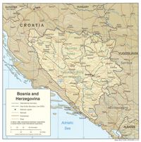
1. (Ottoman Empire) ممالك محرسى وشاهانى بك حاى واولديغى بلاد Istanbul, 1309 Rumi Calendar [1893] (Raster Image)

Raster Stanford University Public content (Ottoman Empire) ممالك محرسى وشاهانى بك حاى واولديغى بلاد Istanbul, 1309 Rumi Calendar [1893] (Raster Image). GeoTIFF. Stanford University. Center for Spatial and Textual Analysis. stanford-ny485wh6734. 1893. Ottoman Army. This layer is a georeferenced image of a map of the Ottoman Empire originally produced in 1893. "This is a key milestone in the history of Ottoman ...

2. Balkan Peninsula Region, 1700-1709 (Raster Image)

Raster Harvard University Public content Balkan Peninsula Region, 1700-1709 (Raster Image). GeoTIFF. Harvard Map Collection, Harvard College Library. harvard-g7430-1700-j3. 1700. Harvard Map Collection, Harvard College Library and Jaillot, Alexis Hubert, 1632?-1712. This layer is a georeferenced raster image of the historic paper map entitled: Estats de l'Empire des Turqs en Europe : divises suivant l'estendue ...

3. Balkan Peninsula Region, 1800 (Raster Image)

Raster Harvard University Public content Balkan Peninsula Region, 1800 (Raster Image). GeoTIFF. Harvard Map Collection, Harvard College Library. harvard-g6800-1800-r4. 1800. Harvard Map Collection, Harvard College Library and Reinecke, J. C. M. (Johann Christoph Matthias), 1770-1818. This layer is a georeferenced raster image of the historic paper map entitled: Charte vom Turkischen Reiche in Europa : nach den neuesten astronomi...

4. Balkan Peninsula Region, 1822 (Raster Image)

Raster Harvard University Public content Balkan Peninsula Region, 1822 (Raster Image). GeoTIFF. Harvard Map Collection, Harvard College Library. harvard-g7430-1822-l3. 1822. Harvard Map Collection, Harvard College Library, Lapie, M. (Pierre), 1779-1850., and Picquet, Charles, 1771-1827. This layer is a georeferenced raster image of the historic paper map entitled: Carte de l'empire Ottoman en Europe, et en Asie, le Chevr. Lapie, ge...

5. Balkan Peninsula Region, ca. 1805 (Raster Image)

Raster Harvard University Public content Balkan Peninsula Region, ca. 1805 (Raster Image). GeoTIFF. Harvard Map Collection, Harvard College Library. harvard-g6800-1805-c4. 1805. Harvard Map Collection, Harvard College Library and Chanlaire, P.-G. (Pierre-Gregoire), 1758-1817. This layer is a georeferenced raster image of the historic paper map entitled: Carte de la Turquie d'Europe, en 15 feuilles : comprenant toute la c...

6. Balkan Peninsula, 1903 (Raster Image)

Raster Harvard University Public content Balkan Peninsula, 1903 (Raster Image). GeoTIFF. Harvard Map Collection, Harvard College Library. harvard-g6800-1903-p4. 1903. Harvard Map Collection, Harvard College Library, Harvard University. Library. Open Collections Program, Peucker, Karl, 1859-1940., Maschek, Rudolph, 1843-1887., Bannwarth, Th., and Artaria & Co. This layer is a georeferenced raster image of the historic paper map entitled: Die Staaten von Sudost=Europa :Rumanien, Serbien, Montenegro, Bulgar...

7. Balkan Peninsula, 1908 (Raster Image)

Raster Harvard University Public content Balkan Peninsula, 1908 (Raster Image). GeoTIFF. Harvard Map Collection, Harvard College Library. harvard-g6800-1908-v6. 1908. Harvard Map Collection, Harvard College Library, Harvard University. Library. Open Collections Program, Vogel, C. (Carl), 1828-1897., Domann, E., Perthes, Justus, firm, Gotha., and Kern, Kuhn und Weiler. This layer is a georeferenced raster image of the historic paper map entitled: Die Balkan-Halbinsel in 4 Blattern : Turkei, Rumanien, Griechenland,...

8. Bosnia and Herzegovina

Princeton University Public content Bosnia and Herzegovina. TIFF. London, H.M. Stationery Off., 1920. princeton-x346d576t. 1920. Great Britain. Foreign Office. Historical Section. A scanned map object.

9. Bosnia and Herzegovina (Geographic Feature Names, 2003)

Point Massachusetts Institute of Technology Public content Bosnia and Herzegovina (Geographic Feature Names, 2003). Shapefile. United States. National Imagery and Mapping Agency. mit-vhsz5my6xbizm. United States. National Imagery and Mapping Agency. Geographic feature names for Bosnia and Herzegovina.

10. Bosnia and Herzegovina : summary map

Princeton University Public content Bosnia and Herzegovina : summary map. TIFF. [Washington, D.C. : Central Intelligence Agency], 1993. princeton-cn69m584s. 1993. United States. Central Intelligence Agency. Relief shown by shading and spot heights. "802127 (R00855) 3-93." Also issued folded to 25 x 14 cm. Includes text, location map, comparative area d...

11. Bosnia and Herzegovina city graphic 1:10,000 : Bijeljina. Series M903

Princeton University Public content Bosnia and Herzegovina city graphic 1:10,000 : Bijeljina. Series M903. TIFF. Washington, D.C. : [s.n.], 1996. princeton-5h73px51j. 1996. Alternate title: Bijeljina. In upper margin: WGS 84.Transverse Mercator projection. Relief shown by 5 meter contour intervals and spot elevations. ...

12. Bosnia and Herzegovina city graphic 1:10,000. Bileca. Series M903

Princeton University Public content Bosnia and Herzegovina city graphic 1:10,000. Bileca. Series M903. TIFF. [S.l.] : Reprinted by National Imagery and Mapping Agency, 1995. princeton-hh63sx75m. 1995. North Decimal Degree 18.450000. South Decimal Degree 18.400. East Decimal Degree 42.900. West Decimal Degree 42.8500. Alternate title:Bileca. Trans...

13. Bosnia and Herzegovina city graphic 1:10,000. Cerska. Series M903

Princeton University Public content Bosnia and Herzegovina city graphic 1:10,000. Cerska. Series M903. TIFF. Fairfax, VA : [s.n.], 1995. princeton-fx719p16n. 1995. Alternate title: Cerska.Transverse Mercator projection. Relief shown by 20 meter contour intervals with supplementary 10 meter contours, and spot e...

14. Bosnia and Herzegovina city graphic 1:10,000. Foca. Series M903

Princeton University Public content Bosnia and Herzegovina city graphic 1:10,000. Foca. Series M903. TIFF. Bethesda, MD : [s.n.], 1995. princeton-jd472z091. 1995. Alternate title: Foca.Transverse Mercator projection. Relief shown by 20 meter contour intervals with supplementary 10 meter contour lintervals, an...

15. Bosnia and Herzegovina city graphic 1:10,000. Pale. Series M903

Princeton University Public content Bosnia and Herzegovina city graphic 1:10,000. Pale. Series M903. TIFF. Bethesda, MD : [s.n.], 2000. princeton-td96k422f. 2000. Alternate title: Pale. Transverse Mercator projection. Relief shown by 20 meter contour intervals with 10 meter supplementary contour intervals, an...

16. Bosnia and Herzegovina city graphic 1:10,000. Rogatica. Series M903

Princeton University Public content Bosnia and Herzegovina city graphic 1:10,000. Rogatica. Series M903. Bethesda, MD : [s.n.], 1995. princeton-5t34sm28k. 1995. Alternate title: Rogatica. Transverse Mercator projection. Relief shown by 20 meter contour ingervals and spot elevation. This sheet falls within N...

17. Bosnia and Herzegovina city graphic 1:10,000. Sokolac. Series M903

Princeton University Public content Bosnia and Herzegovina city graphic 1:10,000. Sokolac. Series M903. TIFF. Bethesda, MD : [s.n.], 1995. princeton-f1881n63j. 1995. Alternate title: Sokolac. Transverse Mercator projection. Relief shown by 20 meter contour intervals and spot elevation. This sheet falls within NK...

18. Bosnia and Herzegovina city graphic 1:10,000. Srebrenica. Series M903

Princeton University Public content Bosnia and Herzegovina city graphic 1:10,000. Srebrenica. Series M903. TIFF. Washington, D.C. : [s.n.], 1995. princeton-s1784n27x. 1995. Alternate title: Srebrenica. Transverse Mercator projection. Relief shown by 20 meter contour intervals and spot elevation. Coordinate conversion W...

19. Bosnia and Herzegovina city graphic 1:10,000. Vlasenica. Series M903

Princeton University Public content Bosnia and Herzegovina city graphic 1:10,000. Vlasenica. Series M903. TIFF. Fairfax, VA : [s.n.], 1995. princeton-m039k633m. 1995. Alternte title: Vlaseniva.Transverse Mercator projection. Relief shown by 20 meter contour intervals, with 10 meter supplementary contour intervals...

20. Bosnia and Herzegovina city graphic 1:12,500. Sarajevo. Series M903

Princeton University Public content Bosnia and Herzegovina city graphic 1:12,500. Sarajevo. Series M903. TIFF. Bethesda, MD : [s.n.], 1997. princeton-0p096857b. 1997. Alternate title: Sarajevo, sheet 2-This sheet falls within NK 34-1, 1501, 1:250,000 and 2782 I, M709, 1:50,000. Transverse Mercator projection. Rel...