Digital Maps and Geospatial Data | Princeton University

Search Results Header

Search Results

Number of results to display per page

1. Maritime Limits: California, 2005

Line Stanford University Public content Maritime Limits: California, 2005. Shapefile. stanford-gy157tv4692. 2005. United States. Office of Coast Survey, United States. Department of Commerce, United States. National Oceanic and Atmospheric Administration, and United States. National Ocean Service. This line shapefile represents the maritime limits of California. NOAA's Office of Coast Survey (OCS) is responsible for generating the 3 Nautical ...

2. Mean Current Velocity, Atlantic Coast, Massachusetts, 2009

Raster Stanford University Public content Mean Current Velocity, Atlantic Coast, Massachusetts, 2009. ArcGRID. stanford-vn042kj0390. 2009. Applied Science Associates and Geological Survey (U.S.). This raster layer contains the mean tidal current speed in the Massachusetts Ocean Partnership (MOP) planning area (and extended rectangular region...

3. Europe and the Near East

University Of Minnesota university-of-minnesota Public content Europe and the Near East. JPEG. , 1929. p16022coll230:2972. 1929. National Geographic Society (U.S.). Cartographic Division. Issued with the National geographic magazine, volume 56, no. 6, Dec. 1929.; Inset: Airways.|83 x 96 centimeters|Scale 1:6,000,000; 94.7 miles to 1 ...
4. The Daily Telegraph war graves map of the Western Front

Image Stanford University Public content The Daily Telegraph war graves map of the Western Front. JPEG 2000. "Geographia". stanford-xx990sy0760. 1919. Gross, Alexander, 1879-1958, Daily Telegraph (London, England), and Geographia Ltd. compiled from official sources under the direction of Alexander Gross. Map of the Western Front in France and Belgium showing cemeteries, railways ...

5. Central America & Panamá

Image Stanford University Public content Central America & Panamá. JPEG 2000. "Geographia" Ltd. stanford-fw822kk2165. 1920. Geographia Ltd. Relief shown by hachures and spot heights. "Copyright. "Geographia" Ltd. ..." Indexed for provinces in Guatemala and El Salvador. Insets: Panamá on...

6. De nederzetting aan de Liesbeek in het begin van 1661

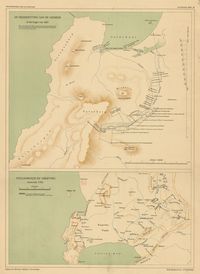
Princeton University Public content De nederzetting aan de Liesbeek in het begin van 1661. TIFF. 's-Gravenhage : M. Nijhoff, [1911-1933]. princeton-rn3013210. 1911. Beekman, A. A. (Anton Albert), 1854-1947. Maps showing Liesbeek in 1661 and Stellenbosch around 1700; relief shown by shading. In top of margin: Geschiedkundige atlas van Nederland. De kolo...

7. De trek der Veeboeren gedurende de 18e eeuw

Princeton University Public content De trek der Veeboeren gedurende de 18e eeuw. TIFF. 's-Gravenhage : M. Nijhoff, [1911-1933]. princeton-j38608782. 1911. Beekman, A. A. (Anton Albert), 1854-1947. Maps showing routes taken by Dutch settlers in South Africa; relief shown by shading. In top of margin: Geschiedkundige atlas van Nederland. De kol...

8. Kaapstad en omgeving omstreeks 1800

Princeton University Public content Kaapstad en omgeving omstreeks 1800. TIFF. 's-Gravenhage : M. Nijhoff, [1911-1933]. princeton-4t64gq00b. 1911. Beekman, A. A. (Anton Albert), 1854-1947. Map showing Cape Town, South Africa, Table Bay and False Bay in 1800; relief shown by shading. In top of margin: Geschiedkundige atlas van Nederlan...

9. Ontwikkeling van de nederzetting aan de Tafelbaai

Princeton University Public content Ontwikkeling van de nederzetting aan de Tafelbaai. TIFF. 's-Gravenhage : M. Nijhoff, [1911-1933]. princeton-x920fz69p. 1911. Beekman, A. A. (Anton Albert), 1854-1947. Maps showing Cape Town, South Africa, and Table Bay, in 1660, 1693, 1767 and 1786; relief shown by shading. In top of margin: Geschiedkundige atlas...

10. Zuid-Afrika onder nederlandsch bewind

Princeton University Public content Zuid-Afrika onder nederlandsch bewind. TIFF. 's-Gravenhage : M. Nijhoff, [1911-1933]. princeton-db78td86n. 1911. Beekman, A. A. (Anton Albert), 1854-1947. Map showing boundaries of Cape Colony in 1798 and 1805 and routes of Olof Bergh in 1682, Simon van der Stel in 1685-1686 and I. Schrijver in 1689; ...

11. Zuid-Afrika onder nederlandsch bewind

Princeton University Public content Zuid-Afrika onder nederlandsch bewind. TIFF. 's-Gravenhage : M. Nijhoff, [1911-1933]. princeton-wd375z12b. 1911. Beekman, A. A. (Anton Albert), 1854-1947. Map showing routes of A. F. Beutler in 1752 and H. Hop and J. Coetsee in 1761-1762; relief shown by shading. "De politieke grenzen zijn die van 177...

12. Zuid-Afrika onder nederlandsch bewind

Princeton University Public content Zuid-Afrika onder nederlandsch bewind. TIFF. 's-Gravenhage : M. Nijhoff, [1911-1933]. princeton-12579v09c. 1911. Beekman, A. A. (Anton Albert), 1854-1947. Map showing routes of J. W. Janssens in 1803 and J. A. de Mist in 1803-1804; relief shown by shading. In top of margin: Geschiedkundige atlas van N...

13. Zuid-Afrika onder nederlandsch bewind : kolonie- en districtengrenzen in de 18de eeuw

Princeton University Public content Zuid-Afrika onder nederlandsch bewind : kolonie- en districtengrenzen in de 18de eeuw. TIFF. 's-Gravenhage : M. Nijhoff, [1911-1933]. princeton-8k71nj92g. 1911. Beekman, A. A. (Anton Albert), 1854-1947. Map showing colonial boundaries in 1750 and 1798; relief shown by shading. In top of margin: Geschiedkundige atlas van Nederland. De koloniën, bla...

14. Pascaerte van Groen-landt, Yslandt, Straet Davids [sic] en Ian Mayen Eylandt : hoemen de selvige van Hitlandt en de noort custen van Schotlandt en Yrlandt beseylen mach

Princeton University Public content Pascaerte van Groen-landt, Yslandt, Straet Davids [sic] en Ian Mayen Eylandt : hoemen de selvige van Hitlandt en de noort custen van Schotlandt en Yrlandt beseylen mach. TIFF. 't Amsterdam : by Iacob Teunisz op't water inde Lootsman, [ca. 1667]. princeton-pn89d842s. 1667. Jacobsz, Theunis, 1632?-1679. Relief shown pictorially. From: Nieuwe en groote Lootsmans zee-spiegel. [Amsterdam : J. Teunisz, ca. 1667] Includes illustrations and rhumb lines.

15. Nova Barbariæ descriptio

University Of Minnesota university-of-minnesota Public content Nova Barbariæ descriptio. JPEG. (Amsterdam). p16022coll230:3732. 1650. Jansson, Jan, 1588-1664. Relief shown pictorially.|33 x 50 centimeters|Scale [1:13,000,000].

16. Polus Antarcticus

University Of Minnesota university-of-minnesota Public content Polus Antarcticus. JPEG. (Amsterdam). p16022coll230:3857. 1650. Jansson, Jan. 500 Hemispherical map centered on the South Pole to the Tropic of Capricorn; includes southern parts of South America and South Africa and the west...

17. Septentrionalium Terrarum descript

University Of Minnesota university-of-minnesota Public content Septentrionalium Terrarum descript. JPEG. (Amsterdam). p16022coll230:856. 1628. Jansson, Jan, 1588-1664.

18. Indiae orientalis insvlarvmqve adiacientivm typvs

University Of Minnesota university-of-minnesota Public content Indiae orientalis insvlarvmqve adiacientivm typvs. JPEG. (Antwerp). p16022coll230:3600. 1592. Ortelius, Abraham, 1527-1598. Relief shown pictorially.; Includes title in cartouche, coat of arms and illustrations of ships, mermaids, and sea monsters.; Includes southwest se...