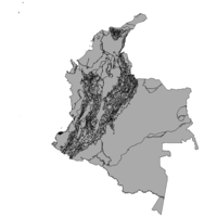
Natural Gas Coverage Per Municipality, Colombia, 2005. Shapefile. Instituto Geografico "Agustin Codazzi". tufts-colombia-naturalgascoveragetotal-05. 2005. This polygon dataset presents the ratio between the percentage of households with natural gas service, over the total number of households per mun...
Power Plant Locations, Colombia, 2005. Shapefile. Instituto Geografico "Agustin Codazzi". tufts-colombia-powerplants-05. 2005. This point dataset represents energy production infrastructure locations in Colombia for the year 2005.
Railway Infrastructure, Colombia, 2011. Shapefile. Instituto Geografico "Agustin Codazzi". tufts-colombia-railways-11. 2011. This line dataset represents railway infrastructure in Colombia at a 1:500,000 scale as of 2011.
Reservoirs and Dams, Colombia, 2011. Shapefile. Instituto Geografico "Agustin Codazzi". tufts-colombia-reservoirs-and-dams-11. 2011. This polygon dataset represents Colombia's dams or reservoirs created artifitially.
Roads, Colombia, 2011. Shapefile. Instituto Geografico "Agustin Codazzi". tufts-colombia-roads-11. 2011. This line dataset represents roads in Colombia at a 1:500,000 scale as of 2011.
Rural and Urban Population Per Municipality, Colombia, 2005. Shapefile. Instituto Geografico "Agustin Codazzi". tufts-colombia-popurbanrural-05. 2005. This polygon dataset presents the urban and rural population per municipality. Data comes from the 2005 census, but it has been reviewed by the DAN...
Rural Aqueduct Coverage Per Municipality, Colombia, 2005. Shapefile. Instituto Geografico "Agustin Codazzi". tufts-colombia-aqueductcoveragerural-05. 2005. This polygon dataset presents the ratio between the percentage of rural households with aqueduct service, over the total number of rural household...
Rural Electricity Coverage Per Municipality, Colombia, 2005. Shapefile. Instituto Geografico "Agustin Codazzi". tufts-colombia-electricitycoveragerural-05. 2005. This polygon dataset presents the ratio between the percentage of rural households with electric service, over the total number of rural household...
Rural Electricity Coverage Per Municipality, Colombia, 2012. Shapefile. Instituto Geografico "Agustin Codazzi". tufts-colombia-electricitycoveragerural-12. 2012. This polygon dataset presents the ratio between the percentage of rural households with electric service, over the total number of rural household...
Rural Housing Quality Per Municipality, Colombia, 2005. Shapefile. Instituto Geografico "Agustin Codazzi". tufts-colombia-ruralhousingquality-05. 2005. This polygon dataset presents a score for rural housing quality per municipality, resulting from the 2005 census. The score which ranges from 0.59 ...
Rural Natural Gas Coverage Per Municipality, Colombia, 2005. Shapefile. Instituto Geografico "Agustin Codazzi". tufts-colombia-naturalgascoveragerural-05. 2005. This polygon dataset presents the ratio between the percentage of rural households with natural gas service, over the total number of rural househ...
Rural Unsatisfied Basic Needs (NBI) Per Municipality, Colombia, 2005. Shapefile. Instituto Geografico "Agustin Codazzi". tufts-colombia-nbirural-05. 2005. This polygon dataset presents the percentage of rural households and persons in conditions of poverty or misery according to unsatisfied basic need...
Rural Unsatisfied Basic Needs (NBI) Per Municipality, Colombia, 2010. Shapefile. Instituto Geografico "Agustin Codazzi". tufts-colombia-nbirural-10. 2010. This polygon dataset presents the percentage of rural households and persons in conditions of poverty or misery according to unsatisfied basic need...
Rural Water Sanitation Coverage Per Municipality, Colombia, 2005. Shapefile. Instituto Geografico "Agustin Codazzi". tufts-colombia-watersanitationcoveragerural-05. 2005. This polygon dataset presents the ratio between the percentage of rural households with water sanitation service, over the total number of rural h...
Total Harvested Agricultural Area Per Municipality, Colombia, 2008. Shapefile. Instituto Geografico "Agustin Codazzi". tufts-colombia-harvestedarea-08. 2008. This polygon dataset presents the total number of hectares harvesed per municipality for the year 2008. No data is available for the following Muni...
Total Livestock Inventory Per Municipality, Colombia, 2006. Shapefile. Instituto Geografico "Agustin Codazzi". tufts-colombia-livestock-06. 2006. This polygon dataset presents the total number of cattle per municipality for the year 2006. No data is available for the following Municipalities ...
Total Number of Households Per Municipality, Colombia, 2005. Shapefile. Instituto Geografico "Agustin Codazzi". tufts-colombia-households-05. 2005. This polygon dataset presents the total number of households per municipality, resulting from the 2005 census. No data is available for the followi...
Total Population Per Municipality, Colombia, 2005. Shapefile. Instituto Geografico "Agustin Codazzi". tufts-colombia-poptotal-05. 2005. This polygon dataset presents the total population per municipality for 2005. Data comes from the 2005 census, but it has been reviewed by the DANE...
Total Sown Agricultural Area Per Municipality, Colombia, 2006. Shapefile. Instituto Geografico "Agustin Codazzi". tufts-colombia-sownarea-06. 2006. This polygon dataset presents the total number of sown hectares per municipality for the year 2006. No data is available for the following Municipa...
Total Sown Agricultural Area Per Municipality, Colombia, 2008. Shapefile. Instituto Geografico "Agustin Codazzi". tufts-colombia-sownarea-08. 2008. This polygon dataset presents the total number of sown hectares per municipality for the year 2008. No data is available for the following Municipa...
Unsatisfied Basic Needs (NBI) Per Municipality, Colombia, 1993. Shapefile. Instituto Geografico "Agustin Codazzi". tufts-colombia-nbi-93. 1993. This polygon dataset presents the percentage of households and persons in conditions of poverty or misery according to unsatisfied basic needs per ...
Unsatisfied Basic Needs (NBI) Per Municipality, Colombia, 2005. Shapefile. Instituto Geografico "Agustin Codazzi". tufts-colombia-nbi-05. 2005. This polygon dataset shows the percentage of households and persons in conditions of poverty or misery according to unsatisfied basic needs for mun...
Unsatisfied Basic Needs (NBI) Per Municipality, Colombia, 2010. Shapefile. Instituto Geografico "Agustin Codazzi". tufts-colombia-nbi-10. 2010. This polygon dataset presents the percentage of households and persons in conditions of poverty or misery according to unsatisfied basic needs per ...
Urban Aqueduct Coverage Per Municipality, Colombia, 2005. Shapefile. Instituto Geografico "Agustin Codazzi". tufts-colombia-aqueductcoverageurban-05. 2005. This polygon dataset presents the ratio between the percentage of urban households with aqueduct service, over the total number of urban household...
Urban Electricity Coverage Per Municipality, Colombia, 2005. Shapefile. Instituto Geografico "Agustin Codazzi". tufts-colombia-electricitycoverageurban-05. 2005. This polygon dataset presents the ratio between the percentage of urban households with electric service, over the total number of urban household...
Urban Electricity Coverage Per Municipality, Colombia, 2012. Shapefile. Instituto Geografico "Agustin Codazzi". tufts-colombia-electricitycoverageurban-12. 2012. This polygon dataset presents the ratio between the percentage of urban households with electric service, over the total number of urban household...
Urban Housing Quality Per Municipality, Colombia, 2005. Shapefile. Instituto Geografico "Agustin Codazzi". tufts-colombia-urbanhousingquality-05. 2005. This polygon dataset presents a score for urban housing quality per municipality, resulting from the 2005 census. The score which ranges from 2.13 ...
Urban Locations for Municipalities, Colombia, 2011. Shapefile. Instituto Geografico "Agustin Codazzi". tufts-colombia-municipalities-urban-location-11. 2011. This point dataset represents main urban location for municipalities and non municipalized areas for Colombia in the year 2011. The shapefile inclu...
Urban Natural Gas Coverage Per Municipality, Colombia, 2005. Shapefile. Instituto Geografico "Agustin Codazzi". tufts-colombia-naturalgascoverageurban-05. 2005. This polygon dataset presents the ratio between the percentage of urban households with natural gas service, over the total number of urban househ...
Urban Unsatisfied Basic Needs (NBI) Per Municipality, Colombia, 2005. Shapefile. Instituto Geografico "Agustin Codazzi". tufts-colombia-nbiurban-05. 2005. This polygon dataset presents the percentage of urban households and persons in conditions of poverty or misery according to unsatisfied basic need...
Urban Unsatisfied Basic Needs (NBI) Per Municipality, Colombia, 2010. Shapefile. Instituto Geografico "Agustin Codazzi". tufts-colombia-nbiurban-10. 2010. This polygon dataset presents the percentage of urban households and persons in conditions of poverty or misery according to unsatisfied basic need...
Urban Water Sanitation Coverage Per Municipality, Colombia, 2005. Shapefile. Instituto Geografico "Agustin Codazzi". tufts-colombia-watersanitationcoverageurban-05. 2005. This polygon dataset presents the ratio between the percentage of urban households with water sanitation service, over the total number of urban h...
Urban/Rural Households Per Municipality, Colombia, 2005. Shapefile. Instituto Geografico "Agustin Codazzi". tufts-colombia-householdsurbanrural-05. 2005. This polygon dataset presents the total number of households per municipality, resulting from the 2005 census. No data is available for the followi...
Water Sanitation Coverage Per Municipality, Colombia, 2005. Shapefile. Instituto Geografico "Agustin Codazzi". tufts-colombia-watersanitationcoveragetotal-05. 2005. This polygon dataset presents the ratio between the percentage of households with water sanitation service, over the total number of households pe...
Water Sanitation Coverage Per Municipality, Colombia, 2008. Shapefile. Instituto Geografico "Agustin Codazzi". tufts-colombia-watersanitationcoveragetotal-08. 2008. This polygon dataset presents the ratio between the percentage of households with water sanitation service, over the total number of households pe...
Water Sanitation Coverage Per Municipality, Colombia, 2011. Shapefile. Instituto Geografico "Agustin Codazzi". tufts-colombia-watersanitationcoveragetotal-11. 2011. This polygon dataset presents the ratio between the percentage of households with water sanitation service, over the total number of households pe...
Airport Cargo Volume Colombia 2007. Shapefile. Instituto Geografico "Agustin Codazzi.". tufts-colombiaairportcargo07. 2007. This point dataset represents locations of airports in Colombia, and indicates the volume of cargo at the airport.
Annual Surface Water Runoff Colombia 2002. Shapefile. Instituto Geografico "Agustin Codazzi.". tufts-colombiaannrunoff02. 2002. This polygon dataset represents the annual surface water runoff yield in Colombia.
Average Precipitation Levels Colombia 1971-2000. Shapefile. Instituto Geografico "Agustin Codazzi.". tufts-colombiaprecipitation7100. 1971. This polygon dataset represents average precipitation levels from 1971-2000 in Colombia.
Average Precipitation Levels Colombia 2008. Shapefile. Instituto Geografico "Agustin Codazzi.". tufts-colombiaprecipitation08. 2008. This polygon dataset represents precipitation levels in Colombia.
Canals Colombia 2012. Shapefile. Instituto Geografico "Agustin Codazzi.". tufts-colombiacanal12. 2012. This line dataset represents canals in Colombia.
Climatic Zones Colombia 2008. Shapefile. Instituto Geografico "Agustin Codazzi.". tufts-colombiaclimaticzones08. 2008. This polygon dataset represents climatic zones in Colombia.
Deglaciation Areas Colombia 1850-2011. Shapefile. Instituto Geografico "Agustin Codazzi.". tufts-colombiadeglaciation5011. 1850. This polygon dataset represents deglaciation zones in Colombia, ranging from 1850 to a projected area in 2011.
Erosion Areas Colombia 2003. Shapefile. Instituto Geografico "Agustin Codazzi.". tufts-colombiaerosion03. 2003. This polygon dataset represents erosion areas in Colombia.
Forest Reserves and Subtractions Colombia 2011. Shapefile. Instituto Geografico "Agustin Codazzi.". tufts-colombiaforestreservsub11. 2011. This polygon dataset represents forest reserves and areas removed from the reserve (referred to as "subtractions") in Colombia.
Indigenous Areas Colombia 2012. Shapefile. Instituto Geografico "Agustin Codazzi.". tufts-colombiaindigenous12. 2012. This polygon dataset represents special area designations, specifically for indigenous peoples (translated from "resguardo indigena".).
International Boundaries Colombia 2010. Shapefile. Instituto Geografico "Agustin Codazzi.". tufts-colombiaintbound10. 2010. This line dataset represents the international boundaries of Colombia.
Irrigation Colombia 2007. Shapefile. Instituto Geografico "Agustin Codazzi.". tufts-colombiairrigation07. 2007. This point dataset represents centers of irrigation in Colombia.
Land for Black Communities Colombia 2010. Shapefile. Instituto Geografico "Agustin Codazzi.". tufts-colombiacomblack10. 2010. This polygon dataset represents special area designations, specifically for black community lands (from the translation "tierras de comunidades neg...
National Parks Colombia 2010. Shapefile. Instituto Geografico "Agustin Codazzi.". tufts-colombianatlparks10. 2010. This polygon dataset represents natural national parks in Colombia.
Oil Stores Colombia 2006. Shapefile. Instituto Geografico "Agustin Codazzi.". tufts-colombiaoilstores06. 2006. This point dataset represents oil stores in Colombia.
Passenger Airports Colombia 2007. Shapefile. Instituto Geografico "Agustin Codazzi.". tufts-colombiaairportpasseng07. 2007. This point dataset represents locations of passenger airports in Colombia.
Petroleum Exploration and Exploitation Areas Colombia 2006. Shapefile. Instituto Geografico "Agustin Codazzi.". tufts-colombiapetrolexplorexploit06. 2006. This polygon dataset represents zones of petroleum exploration and exploitation in Colombia.
Petroleum Locations Colombia 2006. Shapefile. Instituto Geografico "Agustin Codazzi.". tufts-colombiapetroleum06. 2006. This point dataset represents petroleum locations in Colombia.
Ports and Port Capacity Colombia 2006. Shapefile. Instituto Geografico "Agustin Codazzi.". tufts-colombiaportcapacity06. 2006. This point dataset represents ports and their capacities in Colombia.
Primary Roads Colombia 2004. Shapefile. Instituto Geografico "Agustin Codazzi.". tufts-colombiaprimaryroads04. 2006. This line datset represents primary roadways in Colombia.
Railway Infrastructure Colombia 2006. Shapefile. Instituto Geografico "Agustin Codazzi.". tufts-colombiarailwaysinfrast06. 2006. This line dataset represents railway infrastructure in Colombia.
Refineries Colombia 2006. Shapefile. Instituto Geografico "Agustin Codazzi.". tufts-colombiarefinery06. 2006. This point dataset represents refineries in Colombia.
Rivers Colombia 2004. Shapefile. Instituto Geografico "Agustin Codazzi.". tufts-colombiarivers04. 2004. This line dataset represents rivers in Colombia.
Salinization Soil Areas Colombia 2005. Shapefile. Instituto Geografico "Agustin Codazzi.". tufts-colombiasalinization05. 2005. This polygon dataset represents municipal level salinization susceptibility of soils.
Seismic Threats Colombia 1999. Shapefile. Instituto Geografico "Agustin Codazzi.". tufts-colombiaseismic99. 1999. This polygon dataset represents seismic threat areas in Colombia.
Volcanic Activity Colombia 2007. Shapefile. Instituto Geografico "Agustin Codazzi.". tufts-colombiavolcanic07. 2007. This polygon dataset represents the probability of lava, pyroclastic flows, debris flows, and pyroclastics in Colombia.
Volcanoes Colombia 2005. Shapefile. Instituto Geografico "Agustin Codazzi.". tufts-colombiavolcano05. 2005. This point dataset represents the locations of volcanoes in Colombia.
Water Usage Colombia 2010. Shapefile. Instituto Geografico "Agustin Codazzi.". tufts-colombiawateruse10. 2010. This polygon dataset represents the annual water usage in Colombia.
Watersheds and Hydrogeological Zones Colombia 2002. Shapefile. Instituto Geografico "Agustin Codazzi.". tufts-colombiahydrogeo02. 2002. This polygon dataset represents zones of basins and hydrogeological regions with the intent of showing the relationship between surface water and g...
Watersheds Colombia 2002. Shapefile. Instituto Geografico "Agustin Codazzi.". tufts-colombiawatershed02. 2002. This polygon dataset represents water basins in Colombia.
Administrative Boundaries (Parish) Census of Housing, Immigration, and Living Conditions Ecuador 2010. Shapefile. Instituto Geografico Militar (Ecuador). tufts-ecuadorlev3admcensus10. 2010. This polygon dataset represents the 2010 population census performed in Ecuador at the level three administrative level (known as parishes or parro...
Level Three Administrative Boundaries (Parroquias) Population Census Ecuador 2010. Shapefile. Instituto Geografico Militar (Ecuador). tufts-ecuadorlev3populationcensus10. 2010. This polygon dataset represents the 2010 population census performed in Ecuador at the level three administrative level (known as parishes or parro...
Municipality Boundaries Mexico 2013. Shapefile. Instituto Nacional de Estadistica y Geografia (Mexico). tufts-mexicomunicipalityboundaries13. 2013. This polygon dataset shows boundaries for major municipalities in Mexico.
This dataset is part of the most current version of INEGI's "Marco Geos...
Named Urban Areas Mexico 2012. Shapefile. Instituto Nacional de Estadistica y Geografia (Mexico). tufts-mexiconamedurbanareas12. 2012. This polygon dataset shows urban areas in Mexico, identified by their official geographically recognized place name. These urban localities are fur...
Rural Locations Mexico 2012. Shapefile. Instituto Nacional de Estadistica y Geografia (Mexico). tufts-mexicorurallocations12. 2012. This point dataset shows rural locations in Mexico, based on the "Inventario Nacional de Viviendas 2012," or their National Inventory of Homes.
T...
State Boundaries Mexico 2013. Shapefile. Instituto Nacional de Estadistica y Geografia (Mexico). tufts-mexicostateboundaries13. 2013. This polygon dataset shows Mexico's state boundaries.
This dataset is part of the most current version of INEGI's "Marco Geostatistico Nacional,"...
Urban Geostatistical Areas Mexico 2012. Shapefile. Instituto Nacional de Estadistica y Geografia (Mexico). tufts-mexicourbanareas12. 2012.
This polygon dataset shows basic geostatistical urban areas in Mexico. This is based on Mexico's "Inventario Nacional de Viviendas 2012," or their...
Watersheds Colombia 2010. Shapefile. Instituto de Hidrologia, Meteorologia y Estudios Ambientales (Colombia). tufts-colombia-watersheds-10. 2010. This polygon dataset shows major hydrological basins and their sub-basin watersheds for Colombia in the year 2010.
Watersheds Colombia 2013. Shapefile. Instituto de Hidrologia, Meteorologia y Estudios Ambientales (Colombia). tufts-colombia-watersheds-13. 2013. This polygon dataset shows major hydrological basins and their sub-basin watersheds for Colombia in the year 2013.
Colton's map of the United States of America, the British provinces, Mexico, the West Indies and Central America with part of New Granada and Venezuela. JPEG 2000. J. H. Colton, No. 86 Cedar Street,. stanford-fk653xf5711. 1800. Colton, G. Woolworth (George Woolworth), 1827-1901, Atwood, John M., approximately 1818-, Barnard, William S., approximately 1809-, and Colton, J. H. (Joseph Hutchins), 1800-1893. drawn By Geo. W. Colton ; engraved by John. M. Atwood ; border desigd. & engd. by W. S. Barnard. Relief shown by hachures. Latitudinal and long...
Map of the United States of America, the British Provinces, Mexico, the West Indies and Central America with part of New Granada and Venezuela. JPEG 2000. J.H. Colton,. stanford-xv132sx1713. 1800. Colton, G. Woolworth (George Woolworth), 1827-1901, Atwood, John M., approximately 1818-, Barnard, William S., approximately 1809-, and Colton, J. H. (Joseph Hutchins), 1800-1893. drawn by Geo. W. Colton ; engraved by John. M. Atwood ; border desigd. & engd. by W. S. Barnard. Relief shown by hachures. Latitudinal and long...
Map of the United States of America, the British Provinces, Mexico, the West Indies and Central America with part of New Granada and Venezuela. JPEG 2000. J.H. Colton, No. 86 Cedar St.,. stanford-ws823pq6957. 1800. Colton, G. Woolworth (George Woolworth), 1827-1901, Atwood, John M., approximately 1818-, Barnard, William S., approximately 1809-, and Colton, J. H. (Joseph Hutchins), 1800-1893. drawn by Geo. W. Colton ; engraved by John. M. Atwood ; border desigd. & engd. by W. S. Barnard. Relief shown by hachures. Latitudinal and long...
United Fruit Company steamship service : Cuba, Jamaica, Panama, Honduras, Colombia, Salvador, Costa Rica, Guatemala, Central & South America. JPEG. J.W. Clement Co., Matthews-Northrup Works. p16022coll230:2757. 1929. United Fruit Company. Relief shown by shading.; Includes inset of South America.|68 x 88 centimeters|Scale approximately 1:8,000,000.
Colombia Prima or South America. JPEG. James Wyld. p16022coll230:2897. 1833. Delarochette, L. (Louis), 1731-1802. Relief shown pictorially.; Shows borders.; "Publised by James Wyld (successor to Mr. Faden) Geographer to His Majesty. Charing Cross. East. 1833."|...
Nouvelle description de l'Amerique. JPEG 2000. Jean Boisseau. stanford-nh040md8464. 1643. Boisseau, Jean, active 1637-1658. [Jean Boisseau]. California shown as a large island with slightly rounded northern coast and separated from mainland by very narrow east-west "stra...
[World map]. JPEG 2000. Johann Christoph Weigel. stanford-qh664hf2573. 1719. Doppelmayr, Johann Gabriel, 1677-1750. California shown as an unlabeled island with a very indented western coast. Hemispheres are tilted at a 45 degree angle toward the center. Includes...
Peru. JPEG 2000. John Ogilby. stanford-fg622mp4075. 1671. Ogilby, John, 1600-1676. Relief shown pictorially. North oriented toward right of sheet. Latitudinal and longitudinal lines along margins. Imprint taken from atlas. Decorat...
Map of Sierra Nevada de Santa Marta, State of Magdalena, United States of Colombia from a survey by Mr. F. A. A. Simons, 1881. TIFF. London : Edward Stanford, 1881. princeton-ms35tc13d. 1881. Sharbau, H. (Henry). Relief shown by hachures and spot heights. "The National Territory of the Nevada and Motilones is indicated by a yellow line; that of the Goajira b...
Spherical chart comprehending the west coast of America, from the seventh degree of south latitidue to the ninth degree of north latitude : Surveyed by order of the king of Spain in 1791. TIFF. London : Republished ... by Wm. Faden, geographer to his majesty and to his royal highness the Prince of Wales, Charing Cross, Feb. 1 1805. princeton-pk02cd17p. 1805. Spain. Direccion Hidrografica. Relief shown by hachures. Depths shown by soundings. "Etched by H. Wilson." "Approved by the Chart Committee of the Admiralty." Includes five coast...
Claudii Ptolemaei Alexandrini mathematicor principis, opus Geographiae. JPEG 2000. Lorenz Fries,. stanford-nj123hx9157. 1522. Ptolemy, active 2nd century, Fries, Lorenz, 1491-1550, and Grüninger, Johann, -1532?. Woodcuts based on those by Martin Waldseemüller, 1470-1519. Relief shown pictorially. Vellum binding. First 4 and last 4 pages blank (included in p...
Tabula geographica nova omnium oculis exibens et proponens verissimam descriptionem potentissimi et aurifen Regni Guiana. JPEG 2000. M. Becker]. stanford-qw352zt9270. 1599. Hondius, Jodocus, 1563-1612, Bry, Theodor de, 1528-1598, Becker, Matthias, active 1573-1606, and Raleigh, Walter, Sir, 1552?-1618. siti per nautam aliguem qui Gualthero Ralegh navigatione semper adsuit delineata. Relief shown pictorially. Decorative cartouches, compass roses, r...
MassDEP Bureau of Waste Prevention location of Major Facilities Massachusetts 1993-2013. Shapefile. MassGIS (Office : Mass.) . tufts-mafacility9313. 1993. The point dataset represents a statewide point dataset containing the location of a subset of facility types regulated by MassDEP’s Bureau of Waste...
State House of Representatives Districts Massachusetts 2011. Shapefile. MassGIS (Office : Mass.) . tufts-madistrict11. 2011. This polygon dataset represents districts in Massachusetts, which were based on demographic data from the 2010 U.S. Census. They were used for elec...
Congressional Districts New Hampshire 20120509. Shapefile. NH GRANIT (Firm). tufts-nhcongressionaldistricts120509. 2012. This polygon dataset shows the New Hampshire congressional district boundaries for 2012. The US district boundaries were generated based on the 20...
Correctional Institution Locations New Hampshire 2006-2009. Shapefile. NH GRANIT (Firm). tufts-nhcorrectionalinstitutions0609. 2008. This point dataset shows correctional institutions in New Hampshire.
Jails and Prisons (Correctional Institutions).
The Jails and Prisons sub-laye...
Executive Council District Boundaries New Hampshire 2012. Shapefile. NH GRANIT (Firm). tufts-nhexecutivecouncildistricts12. 2012. This polygon dataset shows the Executive Council district boundaries drawn by the New Hampshirec based on the 2010 US Census population. count. Bou...
House Floterial District Boundaries New Hampshire 2012 . Shapefile. NH GRANIT (Firm). tufts-nhhousefloterialdistricts12. 2012. This polygon dataset shows the New Hampshire House of Representatives "floterial" district boundaries drawn by the New Hampshire Legislature based ...