Digital Maps and Geospatial Data | Princeton University

Start over

Current results range from 1522 to 2018

latin america census argentina Remove constraint latin america census argentina

Search Results Header

Search Results

Number of results to display per page

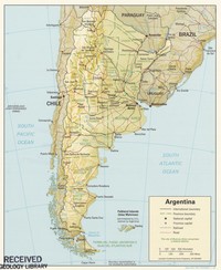
61. Map of the Argentine Republic

Princeton University Public content Map of the Argentine Republic. TIFF. London : Information Office of the Argentine Republic, [1888] (London : Street & Co.). princeton-8g84mp70d. 1888. Weller, Edward, d. 1884. Relief shown by hachures. Insets: England & Wales on the same scale; [and] South America.

62. Argentina, 1996 (relief)

Princeton University Public content Argentina, 1996 (relief). TIFF. Central Intelligence Agency. princeton-hd76s181w. 1996. Central Intelligence Agency. This is a map of Argentina with relief. The map was created by the Central Intelligence Agency.

63. El Salvador housing data from 2007 Census

Princeton University Restricted content El Salvador housing data from 2007 Census. Shapefile. princeton-mg74qt09h. 2007. East View Geospatial. Official population and housing data for El Salvador from the 2007 census. This census is provided at the municipal administrative level (ADM2) and...

64. Dominican Republic demographic data from 2010 census

Princeton University Restricted content Dominican Republic demographic data from 2010 census. Shapefile. princeton-hq37vv57q. 2010. East View Geospatial. Official population and housing data for the Dominican Republic from the 2010 census. This census is provided at the barrio administrative level (A...

65. Dominican Republic housing data from 2010 census

Princeton University Restricted content Dominican Republic housing data from 2010 census. Shapefile. princeton-8623j4732. 2010. East View Geospatial. Official population and housing data for the Dominican Republic from the 2010 census. This census is provided at the barrio administrative level (A...

66. Dominican Republic migration data from 2010 census

Princeton University Restricted content Dominican Republic migration data from 2010 census. Shapefile. princeton-4j03d5645. 2010. East View Geospatial. Official population and housing data for the Dominican Republic from the 2010 census. This census is provided at the barrio administrative level (A...

67. Dominican Republic social data from 2010 census

Princeton University Restricted content Dominican Republic social data from 2010 census. Shapefile. princeton-0r967973d. 2010. East View Geospatial. Official population and housing data for the Dominican Republic from the 2010 census. This census is provided at the barrio administrative level (A...

68. El Salvador economic data from 2007 Census

Princeton University Restricted content El Salvador economic data from 2007 Census. Shapefile. princeton-r781wp02p. 2007. East View Geospatial. Official population and housing data for El Salvador from the 2007 census. This census is provided at the municipal administrative level (ADM2) and...

69. El Salvador social data from 2007 Census

Princeton University Restricted content El Salvador social data from 2007 Census. Shapefile. princeton-c247f0085. 2007. East View Geospatial. Official population and housing data for El Salvador from the 2007 census. This census is provided at the municipal administrative level (ADM2) and...

70. El Salvador transportation data from 2007 Census

Princeton University Restricted content El Salvador transportation data from 2007 Census. Shapefile. princeton-79408416z. 2007. East View Geospatial. Official population and housing data for El Salvador from the 2007 census. This census is provided at the municipal administrative level (ADM2) and...