Synaos (Simav). TIFF. [Athēnai] : Chartographikē Hypēresia Stratou, 1921. princeton-8k71nq04g. 1921. Greece. Stratos. Chartographikē Hypēresia. Relief shown by form lines and spot heights. In lower left margin: " Iounios 1921." This map is part of a set. The Princeton Map Collection has sev...
Central America & Panamá. JPEG 2000. "Geographia" Ltd. stanford-fw822kk2165. 1920. Geographia Ltd. Relief shown by hachures and spot heights. "Copyright. "Geographia" Ltd. ..." Indexed for provinces in Guatemala and El Salvador. Insets: Panamá on...
The Daily Telegraph war graves map of the Western Front. JPEG 2000. "Geographia",. stanford-xx990sy0760. 1919. Gross, Alexander, 1879-1958, Daily Telegraph (London, England), and Geographia Ltd. compiled from official sources under the direction of Alexander Gross. Map of the Western Front in France and Belgium showing cemeteries, railways ...
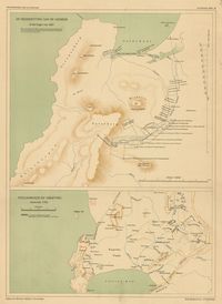
De nederzetting aan de Liesbeek in het begin van 1661. TIFF. 's-Gravenhage : M. Nijhoff, [1911-1933]. princeton-rn3013210. 1911. Beekman, A. A. (Anton Albert), 1854-1947. Maps showing Liesbeek in 1661 and Stellenbosch around 1700; relief shown by shading. In top of margin: Geschiedkundige atlas van Nederland. De kolo...
De trek der Veeboeren gedurende de 18e eeuw. TIFF. 's-Gravenhage : M. Nijhoff, [1911-1933]. princeton-j38608782. 1911. Beekman, A. A. (Anton Albert), 1854-1947. Maps showing routes taken by Dutch settlers in South Africa; relief shown by shading. In top of margin: Geschiedkundige atlas van Nederland. De kol...
Kaapstad en omgeving omstreeks 1800. TIFF. 's-Gravenhage : M. Nijhoff, [1911-1933]. princeton-4t64gq00b. 1911. Beekman, A. A. (Anton Albert), 1854-1947. Map showing Cape Town, South Africa, Table Bay and False Bay in 1800; relief shown by shading. In top of margin: Geschiedkundige atlas van Nederlan...
Ontwikkeling van de nederzetting aan de Tafelbaai. TIFF. 's-Gravenhage : M. Nijhoff, [1911-1933]. princeton-x920fz69p. 1911. Beekman, A. A. (Anton Albert), 1854-1947. Maps showing Cape Town, South Africa, and Table Bay, in 1660, 1693, 1767 and 1786; relief shown by shading. In top of margin: Geschiedkundige atlas...
Zuid-Afrika onder nederlandsch bewind. TIFF. 's-Gravenhage : M. Nijhoff, [1911-1933]. princeton-db78td86n. 1911. Beekman, A. A. (Anton Albert), 1854-1947. Map showing boundaries of Cape Colony in 1798 and 1805 and routes of Olof Bergh in 1682, Simon van der Stel in 1685-1686 and I. Schrijver in 1689; ...
Zuid-Afrika onder nederlandsch bewind. TIFF. 's-Gravenhage : M. Nijhoff, [1911-1933]. princeton-wd375z12b. 1911. Beekman, A. A. (Anton Albert), 1854-1947. Map showing routes of A. F. Beutler in 1752 and H. Hop and J. Coetsee in 1761-1762; relief shown by shading. "De politieke grenzen zijn die van 177...
Zuid-Afrika onder nederlandsch bewind. TIFF. 's-Gravenhage : M. Nijhoff, [1911-1933]. princeton-12579v09c. 1911. Beekman, A. A. (Anton Albert), 1854-1947. Map showing routes of J. W. Janssens in 1803 and J. A. de Mist in 1803-1804; relief shown by shading. In top of margin: Geschiedkundige atlas van N...
Zuid-Afrika onder nederlandsch bewind : kolonie- en districtengrenzen in de 18de eeuw. TIFF. 's-Gravenhage : M. Nijhoff, [1911-1933]. princeton-8k71nj92g. 1911. Beekman, A. A. (Anton Albert), 1854-1947. Map showing colonial boundaries in 1750 and 1798; relief shown by shading. In top of margin: Geschiedkundige atlas van Nederland. De koloniën, bla...
Pascaerte van Groen-landt, Yslandt, Straet Davids [sic] en Ian Mayen Eylandt : hoemen de selvige van Hitlandt en de noort custen van Schotlandt en Yrlandt beseylen mach. TIFF. 't Amsterdam : by Iacob Teunisz op't water inde Lootsman, [ca. 1667]. princeton-pn89d842s. 1667. Jacobsz, Theunis, 1632?-1679. Relief shown pictorially. From: Nieuwe en groote Lootsmans zee-spiegel. [Amsterdam : J. Teunisz, ca. 1667] Includes illustrations and rhumb lines.
Map of Boston and part of its suburbs~~showing public recreation grounds, burial grounds and certain other public properties generally free from buildings. JPEG. (Boston). p16022coll205:289. 1886. Boston (Mass.). Parks and Recreation Department.
New map of Boston comprising the whole city with the new boundaries of the wards~~Engraved expressly for the Boston almanac for 1853. JPEG. (Boston). p16022coll205:488. 1853.
Map of Boston showing health districts and undrained and filled land. JPEG. (Boston?). p16022coll205:282. 1900. Relief shown by hachures. Dimensions: 60 x 51 centimeters.
Index map showing the principal river basins within the state. JPEG. (Boston], ). p16022coll230:1367. 1875. Massachusetts. Department of Public Health.
[North American maps from the Atlas universal de géographie physique, politique, statistique et minéralogique]. JPEG. (Brussels). p16022coll230:991. 1827. Vandermaelen, Philippe, 1795-1869.
Pictorial map of Jasper National Park and Mount Robson Park~~showing trails and motor roads through the heart of the Canadian Rockies. JPEG. (Canada). p16022coll230:887. 1930.
Chapman's township map of the northwest : compiled from the United States surveys and other authentic sources. JPEG2000. (Ferd. Mayer & Co. (New York))|A.S. Barnes & Co. (New York)|Dyer & Pasmore (Milwaukee, Wisconsin)|J.B. Lippincott & Co. (Philadelphia). a02a3c00-994e-0134-2096-0050569601ca-4. 1857. Chapman, Silas. ca. 1:1,500,000.
Partie occidentale du Canada. JPEG. (Genève?). p16022coll230:474. 1780. Bonne, Robert, 1727-1794. Longitude du méridien de l'isle de Fer; longitude du méridien de Paris." Relief shown pictorially. "Liv. XV, XVI, XVII." "No. 45. Dimension...
A correct map of the United States of North America~~including the British and Spanish territories carefully laid down agreeable to the treaty of 1784. JPEG. (London). p16022coll230:665. 1787. Bowen, Thomas, -1790.
A Map of Old Greenland or Øster Bygd & Wester Bygd : agreeable to Egede's late description of Greenland. ; A Map of the Islands of Ferro or Farro according to Jacobson Debes. ; An improved map of Iceland. JPEG. (London). p16022coll230:338. 1750. Bowen, Emanuel, 1693 or 1694-1767. Cartographic Details: Scales differ. Inset diagram: "A draught of the whirlpool on the south east of Sumbo Rocks w. the soundings." Numbered "N⁰76....
A new map of North America~~wherein is exactly described all ye European settlements, with whatever else is remarkable in the West Indies, from the latest and best discoveries; adorn'd with views and plans of the most considerable towns, harbours, &c. JPEG. (London). p16022coll230:763. 1776.
Carta universal en que se contierne todo lo que del mundo se ha descubierto fasta agora hizola Diego Ribero cosmographo de Su magestad. Año de 1529 é Sevilla. JPEG. (London). p16022coll230:876. 1885.
The British Isles~~comprehending Great Britain and Ireland with The Adjacent Islands. JPEG. (London). p16022coll230:434. 1774. Dunn, Samuel, -1794. Relief shown pictorially. "London : printed for Rob't Sayer, No.53 in Fleet Street as the Act directed 10 Jan. 1774." Appears to be a two page ...
The kingdom of Ireland. JPEG. (London). p16022coll230:436. 1695. Morden, Robert, -1703. Relief shown pictorially. Detached from an edition of Camden, William. Camden's Britannia -- London, [1695-1772]. Dimensions: 41.7 x 33.6 centime...
A new map of the English empire in America viz Virginia, New York, Maryland, New Jersey, Carolina, New England, Pennsylvania, New England, Pennsylvania, New Foundland, New France & c. JPEG. (London?). p16022coll230:724. 1719. Senex, John, -1740.
Map of Georgia & Alabam : exhibiting the post offices, post roads, canals, rail roads &c. JPEG. (London], ). p16022coll230:1541. 1839. Burr, David H., 1803-1875. Detailed map showing relief by hachures, drainage, township and county boundaries, cities and towns, canals, roads, and railroads. Dimensions: 91 x...
Map of Kentucky & Tennessee : exhibiting the post offices, post roads, canals, rail roads, &c. JPEG. (London], ). p16022coll230:1526. 1839. Burr, David H., 1803-1875. Detailed map showing relief by hachures, drainage, township and county boundaries, cities and towns, canals, roads, and railroads. Dimensions: 81 x...
Map of the proposed division of the town of Medford, Middlesex County, Mass. JPEG. (Massachusetts?). p16022coll205:274. 1884. Sampson, George T. Relief shown by hachures. Includes note. Dimensions: 44 x 53 centimeters.