Digital Maps and Geospatial Data | Princeton University

Search Results Header

Search Results

Number of results to display per page

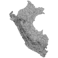
1. Peru social data from 2007 census

Princeton University Restricted content Peru social data from 2007 census. Shapefile. princeton-37720m89d. 2007. East View Geospatial. Official population and housing data for Peru from the 2007 census. This census is provided at the district administrative level (ADM3) and include...

2. Peru migration data from 2007 census

Princeton University Restricted content Peru migration data from 2007 census. Shapefile. princeton-m900p258v. 2007. East View Geospatial. Official population and housing data for Peru from the 2007 census. This census is provided at the district administrative level (ADM3) and include...

3. Peru housing data from 2007 census

Princeton University Restricted content Peru housing data from 2007 census. Shapefile. princeton-gh93h6673. 2007. East View Geospatial. Official population and housing data for Peru from the 2007 census. This census is provided at the district administrative level (ADM3) and include...

4. Peru economic data from 2007 census

Princeton University Restricted content Peru economic data from 2007 census. Shapefile. princeton-br86bb72k. 2007. East View Geospatial. Official population and housing data for Peru from the 2007 census. This census is provided at the district administrative level (ADM3) and include...

5. Peru demographic data from 2007 census

Princeton University Restricted content Peru demographic data from 2007 census. Shapefile. princeton-70795g80r. 2007. East View Geospatial. Official population and housing data for Peru from the 2007 census. This census is provided at the district administrative level (ADM3) and include...

6. Caribbean America

Princeton University Public content Caribbean America. TIFF. [Washington, D.C. : Central Intelligence Agency], 1986. princeton-dv13zv863. 1986. United States. Central Intelligence Agency. "800371 7-86." Relief shown by shading and spot heights. "Boundary representation is not necessarily authoritative.".

7. Peru

Image Stanford University Public content Peru. JPEG 2000. John Ogilby. stanford-fg622mp4075. 1671. Ogilby, John, 1600-1676. Relief shown pictorially. North oriented toward right of sheet. Latitudinal and longitudinal lines along margins. Imprint taken from atlas. Decorat...

8. Peru

Princeton University Public content Peru. TIFF. [Netherlands? : s.n., ca. 1650 to 1700]. princeton-3t945t22q. 1650. Relief shown pictorially. Includes ill.

10. Peru

Princeton University Public content Peru. TIFF. [Philadelphia : M. Carey, 1814 (Philadelphia : T.S. Manning)]. princeton-cf95jd91t. 1814. Carey, Mathew, 1760-1839. Relief shown by hachures. Bar scale is incorrect. Includes inset map of eastern portion of Peru. Prime meridians: London and Philadelphia. In upper...

11. Nighttime Lights of Latin America and the Caribbean - Human Settlements, 1994-1995

Raster Stanford University Public content Nighttime Lights of Latin America and the Caribbean - Human Settlements, 1994-1995. GeoTIFF. National Geophysical and Solar-Terrestrial Data Center. stanford-vt902fz3161. 2009. National Geophysical and Solar-Terrestrial Data Center. This map shows light sources from human settlements in Latin America and the Caribbean as observed during 1994-1995. The Defense Meteorological Sat...

12. Argentina migration data from 2010 census

Princeton University Restricted content Argentina migration data from 2010 census. Shapefile. princeton-dcw9505b06r. 2010. East View Geospatial. Official migration data from the 2010 Argentina census. Data are presented at the level of townships (fourth-order administrative divisions).

13. Argentina demographic data from 2010 census

Princeton University Restricted content Argentina demographic data from 2010 census. Shapefile. princeton-dcrj430g155. 2010. East View Geospatial. Official demographic data from the 2010 Argentina census. Data are presented at the level of townships (fourth-order administrative divisions).

14. Argentina employment data from 2010 census

Princeton University Restricted content Argentina employment data from 2010 census. Shapefile. princeton-dccc08hs21j. 2010. East View Geospatial. Official employment data from the 2010 Argentina census. Data are presented at the level of townships (fourth-order administrative divisions).

15. Argentina education data from 2010 census

Princeton University Restricted content Argentina education data from 2010 census. Shapefile. princeton-dch128nr30f. 2010. East View Geospatial. Official education data from the 2010 Argentina census. Data are presented at the level of townships (fourth-order administrative divisions).

16. Argentina housing data from 2010 census

Princeton University Restricted content Argentina housing data from 2010 census. Shapefile. princeton-dcms35tm23r. 2010. East View Geospatial. Official housing data from the 2010 Argentina census. Data are presented at the level of townships (fourth-order administrative divisions).

17. Guyana housing data from 2012 census

Princeton University Restricted content Guyana housing data from 2012 census. Shapefile. princeton-ks65hm35f. 2012. East View Geospatial. Official population and housing data for Guyana from the 2012 census. This census is provided at the council administrative level (ADM3) and includ...

18. Guyana social data from 2012 census

Princeton University Restricted content Guyana social data from 2012 census. Shapefile. princeton-3t945z930. 2012. East View Geospatial. Official population and housing data for Guyana from the 2012 census. This census is provided at the council administrative level (ADM3) and includ...

19. Guyana economic data from 2012 census

Princeton University Restricted content Guyana economic data from 2012 census. Shapefile. princeton-qj72pg280. 2012. East View Geospatial. Official population and housing data for Guyana from the 2012 census. This census is provided at the council administrative level (ADM3) and includ...

20. Guyana transportation data from 2012 census

Princeton University Restricted content Guyana transportation data from 2012 census. Shapefile. princeton-02871402z. 2012. East View Geospatial. Official population and housing data for Guyana from the 2012 census. This census is provided at the council administrative level (ADM3) and includ...

21. Uruguay migration data from 2011 census

Princeton University Restricted content Uruguay migration data from 2011 census. Shapefile. princeton-9s161f33z. 2011. East View Geospatial. Official population and housing data for Uruguay from the 2011 census. This census is provided at the census tract administrative level (ADM3) and ...

22. Uruguay housing data from 2011 census

Princeton University Restricted content Uruguay housing data from 2011 census. Shapefile. princeton-q237j111w. 2011. East View Geospatial. Official population and housing data for Uruguay from the 2011 census. This census is provided at the census tract administrative level (ADM3) and ...

23. Uruguay economic data from 2011 census

Princeton University Restricted content Uruguay economic data from 2011 census. Shapefile. princeton-2b88qm34p. 2011. East View Geospatial. Official population and housing data for Uruguay from the 2011 census. This census is provided at the census tract administrative level (ADM3) and ...

24. Uruguay transportation data from 2011 census

Princeton University Restricted content Uruguay transportation data from 2011 census. Shapefile. princeton-k930c5205. 2011. East View Geospatial. Official population and housing data for Uruguay from the 2011 census. This census is provided at the census tract administrative level (ADM3) and ...

25. Uruguay social data from 2011 census

Princeton University Restricted content Uruguay social data from 2011 census. Shapefile. princeton-fj236926h. 2011. East View Geospatial. Official population and housing data for Uruguay from the 2011 census. This census is provided at the census tract administrative level (ADM3) and ...

26. Uruguay demographic data from 2011 census

Princeton University Restricted content Uruguay demographic data from 2011 census. Shapefile. princeton-6395wg258. 2011. East View Geospatial. Official population and housing data for Uruguay from the 2011 census. This census is provided at the census tract administrative level (ADM3) and ...

27. Colombia demographic data from 2005 census

Princeton University Restricted content Colombia demographic data from 2005 census. Shapefile. princeton-t722hg80m. 2005. East View Geospatial. Official population and housing data for Colombia from the 2005 census. This census is provided at the manzana administrative level (ADM6) and incl...

28. Colombia economic data from 2005 census

Princeton University Restricted content Colombia economic data from 2005 census. Shapefile. princeton-pg15bm88x. 2005. East View Geospatial. Official population and housing data for Colombia from the 2005 census. This census is provided at the manzana administrative level (ADM6) and incl...

29. Colombia housing data from 2005 census

Princeton University Restricted content Colombia housing data from 2005 census. Shapefile. princeton-jq085r97b. 2005. East View Geospatial. Official population and housing data for Colombia from the 2005 census. This census is provided at the manzana administrative level (ADM6) and incl...

30. Colombia migration data from 2005 census

Princeton University Restricted content Colombia migration data from 2005 census. Shapefile. princeton-dz010x052. 2005. East View Geospatial. Official population and housing data for Colombia from the 2005 census. This census is provided at the manzana administrative level (ADM6) and incl...

31. Colombia social data from 2005 census

Princeton University Restricted content Colombia social data from 2005 census. Shapefile. princeton-9593v212m. 2005. East View Geospatial. Official population and housing data for Colombia from the 2005 census. This census is provided at the manzana administrative level (ADM6) and incl...

32. Chile social data from 2002 census

Princeton University Restricted content Chile social data from 2002 census. Shapefile. princeton-tx31qr84m. 2002. East View Geospatial. Official population and housing data for Chile from the 2002 census. This census is provided at the manzana administrative level (ADM6) and include...

33. Chile economic data from 2002 census

Princeton University Restricted content Chile economic data from 2002 census. Shapefile. princeton-q524jw919. 2002. East View Geospatial. Official population and housing data for Chile from the 2002 census. This census is provided at the manzana administrative level (ADM6) and include...

34. Venezuela social data from 2011 census

Princeton University Restricted content Venezuela social data from 2011 census. Shapefile. princeton-db78tm211. 2011. East View Geospatial. Official population and housing data for Venezuela from the 2011 census. This census is provided at the parroquias administrative level (ADM3) and ...

35. Venezuela demographic data from 2011 census

Princeton University Restricted content Venezuela demographic data from 2011 census. Shapefile. princeton-2227mx843. 2011. East View Geospatial. Official population and housing data for Venezuela from the 2011 census. This census is provided at the parroquias administrative level (ADM3) and ...

36. Chile demographic data from 2002 census

Princeton University Restricted content Chile demographic data from 2002 census. Shapefile. princeton-3f462d60j. 2002. East View Geospatial. Official population and housing data for Chile from the 2002 census. This census is provided at the manzana administrative level (ADM6) and include...

37. Venezuela migration data from 2011 census

Princeton University Restricted content Venezuela migration data from 2011 census. Shapefile. princeton-ns064f228. 2011. East View Geospatial. Official population and housing data for Venezuela from the 2011 census. This census is provided at the parroquias administrative level (ADM3) and ...

38. Venezuela economic data from 2011 census

Princeton University Restricted content Venezuela economic data from 2011 census. Shapefile. princeton-x920g504f. 2011. East View Geospatial. Official population and housing data for Venezuela from the 2011 census. This census is provided at the parroquias administrative level (ADM3) and ...

39. Chile housing data from 2002 census

Princeton University Restricted content Chile housing data from 2002 census. Shapefile. princeton-bz60d4410. 2002. East View Geospatial. Official population and housing data for Chile from the 2002 census. This census is provided at the manzana administrative level (ADM6) and include...

40. Chile migration data from 2002 census

Princeton University Restricted content Chile migration data from 2002 census. Shapefile. princeton-76537850n. 2002. East View Geospatial. Official population and housing data for Chile from the 2002 census. This census is provided at the manzana administrative level (ADM6) and include...

41. Venezuela housing data from 2011 census

Princeton University Restricted content Venezuela housing data from 2011 census. Shapefile. princeton-sj139913v. 2011. East View Geospatial. Official population and housing data for Venezuela from the 2011 census. This census is provided at the parroquias administrative level (ADM3) and ...

42. Chile transportation data from 2002 census

Princeton University Restricted content Chile transportation data from 2002 census. Shapefile. princeton-zp38wm78s. 2002. East View Geospatial. Official population and housing data for Chile from the 2002 census. This census is provided at the manzana administrative level (ADM6) and include...

43. Venezuela transportation data from 2011 census

Princeton University Restricted content Venezuela transportation data from 2011 census. Shapefile. princeton-j098zk30x. 2011. East View Geospatial. Official population and housing data for Venezuela from the 2011 census. This census is provided at the parroquias administrative level (ADM3) and ...

44. Paraguay economic data from 2002 census

Princeton University Restricted content Paraguay economic data from 2002 census. Shapefile. princeton-h128nn86b. 2002. East View Geospatial. Official population and housing data for Paraguay from the 2002 census. This census is provided at the manzana administrative level (ADM6) and incl...

45. Paraguay transportation data from 2002 census

Princeton University Restricted content Paraguay transportation data from 2002 census. Shapefile. princeton-0z709461n. 2002. East View Geospatial. Official population and housing data for Paraguay from the 2002 census. This census is provided at the manzana administrative level (ADM6) and incl...

46. Paraguay demographic data from 2002 census

Princeton University Restricted content Paraguay demographic data from 2002 census. Shapefile. princeton-4q77g051w. 2002. East View Geospatial. Official population and housing data for Paraguay from the 2002 census. This census is provided at the manzana administrative level (ADM6) and incl...

47. Paraguay social data from 2002 census

Princeton University Restricted content Paraguay social data from 2002 census. Shapefile. princeton-mp48sm931. 2002. East View Geospatial. Official population and housing data for Paraguay from the 2002 census. This census is provided at the manzana administrative level (ADM6) and incl...

48. Paraguay migration data from 2002 census

Princeton University Restricted content Paraguay migration data from 2002 census. Shapefile. princeton-w6634b79g. 2002. East View Geospatial. Official population and housing data for Paraguay from the 2002 census. This census is provided at the manzana administrative level (ADM6) and incl...

49. Paraguay housing data from 2002 census

Princeton University Restricted content Paraguay housing data from 2002 census. Shapefile. princeton-rf55zg853. 2002. East View Geospatial. Official population and housing data for Paraguay from the 2002 census. This census is provided at the manzana administrative level (ADM6) and incl...

50. Nicaragua migration data from 2005 census

Princeton University Restricted content Nicaragua migration data from 2005 census. Shapefile. princeton-2801pq49z. 2005. East View Geospatial. Official population and housing data for Nicaragua from the 2005 census. This census is provided at the barrio administrative level (ADM4) and incl...

51. Nicaragua economic data from 2005 census

Princeton University Restricted content Nicaragua economic data from 2005 census. Shapefile. princeton-6108vk41s. 2005. East View Geospatial. Official population and housing data for Nicaragua from the 2005 census. This census is provided at the barrio administrative level (ADM4) and incl...

52. Nicaragua housing data from 2005 census

Princeton University Restricted content Nicaragua housing data from 2005 census. Shapefile. princeton-9s161f32g. 2005. East View Geospatial. Official population and housing data for Nicaragua from the 2005 census. This census is provided at the barrio administrative level (ADM4) and incl...

53. Nicaragua demographic data from 2005 census

Princeton University Restricted content Nicaragua demographic data from 2005 census. Shapefile. princeton-pz50h426r. 2005. East View Geospatial. Official population and housing data for Nicaragua from the 2005 census. This census is provided at the barrio administrative level (ADM4) and incl...

54. Nicaragua transportation data from 2005 census

Princeton University Restricted content Nicaragua transportation data from 2005 census. Shapefile. princeton-k643b832z. 2005. East View Geospatial. Official population and housing data for Nicaragua from the 2005 census. This census is provided at the barrio administrative level (ADM4) and incl...

55. Nicaragua social data from 2005 census

Princeton University Restricted content Nicaragua social data from 2005 census. Shapefile. princeton-ff365d41c. 2005. East View Geospatial. Official population and housing data for Nicaragua from the 2005 census. This census is provided at the barrio administrative level (ADM4) and incl...

56. Argentina social data from 2010 census

Princeton University Restricted content Argentina social data from 2010 census. Shapefile. princeton-z029pb71b. 2010. East View Geospatial. Official population housing data for Argentina down to township, including 52408 vector polygons with native-language names and unique identifier c...

57. Argentina housing data from 2010 census

Princeton University Restricted content Argentina housing data from 2010 census. Shapefile. princeton-6d5703605. 2010. East View Geospatial. Official population housing data for Argentina down to township, including 52408 vector polygons with native-language names and unique identifier c...

58. Argentina demographic data from 2010 census

Princeton University Restricted content Argentina demographic data from 2010 census. Shapefile. princeton-fx719t474. 2010. East View Geospatial. Official population housing data for Argentina down to township, including 52408 vector polygons with native-language names and unique identifier c...

59. Argentina economic data from 2010 census

Princeton University Restricted content Argentina economic data from 2010 census. Shapefile. princeton-b5644z54t. 2010. East View Geospatial. Official population housing data for Argentina down to township, including 52408 vector polygons with native-language names and unique identifier c...

60. Argentina migration data from 2010 census

Princeton University Restricted content Argentina migration data from 2010 census. Shapefile. princeton-2n49t769m. 2010. East View Geospatial. Official population housing data for Argentina down to township, including 52408 vector polygons with native-language names and unique identifier c...

61. Peru Census 2007

Collection Stanford University Public content Peru Census 2007. stanford-wb101td2654. 2018. East View Cartographic, Inc. This collection contains shapefiles representing key statistics from the 2007 Census of Peru. The original questionairre along with other supportin...

62. Peru

Image Stanford University Public content Peru. JPEG 2000. Reproduced by the OSS Repro. Section. stanford-kd756zj4922. 1943. United States Office of Strategic Services. Research and Analysis Branch. compiled and drawn in the Branch of Research and Analysis, O.S.S. "Map no. 1967, January 22, 1943." Inset: South America.

63. Pascaerte van Nova Hispania, Chili, Peru, en Guatimala

Princeton University Public content Pascaerte van Nova Hispania, Chili, Peru, en Guatimala. TIFF. t'Amsterdam : by Pieter Goos, op't Waater inde Verguelde Zeespiegel, Ao. 1666. princeton-gh93h195d. 1666. Goos, Pieter, approximately 1616-1675 and Goos, Pieter, ca. 1616-1675. From : De Zee-atlas ofte water-wereld ... T'Amsterdam, by Pieter Goos... 1666. Nautical chart showing the coastline of Central America, Peru, and C...

64. Johnson's Venezuela, New Granada, Ecuador, Peru & Bolivia, Chile and Guiana

Princeton University Public content Johnson's Venezuela, New Granada, Ecuador, Peru & Bolivia, Chile and Guiana. TIFF. [ New York] : Johnson & Browning, c [1860]. princeton-n296x157s. 1860. Johnson, A. J. (Alvin Jewett), 1827-1884. Relief shown by hachures. Inset maps: Chile -- City of Lima. Inset views: Juan Fernandez or Mas a Tierra -- City of Valparaiso. Prime meridians: Gr...

65. El Salvador housing data from 2007 Census

Princeton University Restricted content El Salvador housing data from 2007 Census. Shapefile. princeton-mg74qt09h. 2007. East View Geospatial. Official population and housing data for El Salvador from the 2007 census. This census is provided at the municipal administrative level (ADM2) and...

66. Dominican Republic demographic data from 2010 census

Princeton University Restricted content Dominican Republic demographic data from 2010 census. Shapefile. princeton-hq37vv57q. 2010. East View Geospatial. Official population and housing data for the Dominican Republic from the 2010 census. This census is provided at the barrio administrative level (A...

67. Dominican Republic housing data from 2010 census

Princeton University Restricted content Dominican Republic housing data from 2010 census. Shapefile. princeton-8623j4732. 2010. East View Geospatial. Official population and housing data for the Dominican Republic from the 2010 census. This census is provided at the barrio administrative level (A...

68. Dominican Republic migration data from 2010 census

Princeton University Restricted content Dominican Republic migration data from 2010 census. Shapefile. princeton-4j03d5645. 2010. East View Geospatial. Official population and housing data for the Dominican Republic from the 2010 census. This census is provided at the barrio administrative level (A...

69. Dominican Republic social data from 2010 census

Princeton University Restricted content Dominican Republic social data from 2010 census. Shapefile. princeton-0r967973d. 2010. East View Geospatial. Official population and housing data for the Dominican Republic from the 2010 census. This census is provided at the barrio administrative level (A...

70. El Salvador economic data from 2007 Census

Princeton University Restricted content El Salvador economic data from 2007 Census. Shapefile. princeton-r781wp02p. 2007. East View Geospatial. Official population and housing data for El Salvador from the 2007 census. This census is provided at the municipal administrative level (ADM2) and...

71. El Salvador social data from 2007 Census

Princeton University Restricted content El Salvador social data from 2007 Census. Shapefile. princeton-c247f0085. 2007. East View Geospatial. Official population and housing data for El Salvador from the 2007 census. This census is provided at the municipal administrative level (ADM2) and...

72. El Salvador transportation data from 2007 Census

Princeton University Restricted content El Salvador transportation data from 2007 Census. Shapefile. princeton-79408416z. 2007. East View Geospatial. Official population and housing data for El Salvador from the 2007 census. This census is provided at the municipal administrative level (ADM2) and...

73. El Salvador demographic data from 2007 Census

Princeton University Restricted content El Salvador demographic data from 2007 Census. Shapefile. princeton-w0892h93t. 2007. East View Geospatial. Official population and housing data for El Salvador from the 2007 census. This census is provided at the municipal administrative level (ADM2) and...

74. El Salvador migration data from 2007 Census

Princeton University Restricted content El Salvador migration data from 2007 Census. Shapefile. princeton-gq67jz17f. 2007. East View Geospatial. Official population and housing data for El Salvador from the 2007 census. This census is provided at the municipal administrative level (ADM2) and...

75. Dominican Republic economic data from 2010 census

Princeton University Restricted content Dominican Republic economic data from 2010 census. Shapefile. princeton-cz30q064d. 2010. East View Geospatial. Official population and housing data for the Dominican Republic from the 2010 census. This census is provided at the barrio administrative level (A...

76. Costa Rica demographic data from 2011 census

Princeton University Restricted content Costa Rica demographic data from 2011 census. Shapefile. princeton-5d86p6211. 2011. East View Geospatial. Official population and housing data for Costa Rica from the 2011 census. This census is provided at the district administrative level (ADM3) and i...

77. Costa Rica economic data from 2011 census

Princeton University Restricted content Costa Rica economic data from 2011 census. Shapefile. princeton-1r66j711n. 2011. East View Geospatial. Official population and housing data for Costa Rica from the 2011 census. This census is provided at the district administrative level (ADM3) and i...

78. Costa Rica social data from 2011 census

Princeton University Restricted content Costa Rica social data from 2011 census. Shapefile. princeton-ng451q507. 2011. East View Geospatial. Official population and housing data for Costa Rica from the 2011 census. This census is provided at the district administrative level (ADM3) and i...

79. Costa Rica migration data from 2011 census

Princeton University Restricted content Costa Rica migration data from 2011 census. Shapefile. princeton-s7526k40b. 2011. East View Geospatial. Official population and housing data for Costa Rica from the 2011 census. This census is provided at the district administrative level (ADM3) and i...

80. Costa Rica housing data from 2011 census

Princeton University Restricted content Costa Rica housing data from 2011 census. Shapefile. princeton-x059cf32j. 2011. East View Geospatial. Official population and housing data for Costa Rica from the 2011 census. This census is provided at the district administrative level (ADM3) and i...

81. Peruuiae auriferæ regionis typus

Princeton University Public content Peruuiae auriferæ regionis typus. TIFF. [Antwerp : Plantin, 1608?]. princeton-r207tr780. 1608. Ortelius, Abraham, 1527-1598. Shows portion of Central America and northwestern South America. Relief shown pictorially. Appears in the author's Theatrum orbis terrarum. Addidta...

82. Peru & Bolivia [map] / by J. Arrowsmith

University Of Illinois Urbana Champaign Public content Peru & Bolivia [map] / by J. Arrowsmith. JPEG2000. a0428900-994e-0134-2096-0050569601ca-4. 1834. Arrowsmith, J., 1832-1846. London atlas. [J. Arrowsmith (London), 1832-1846]. Vol. 4, no. 48;1 map, colored;51 x 59 cm.;ca. 1:5,000,000.

83. La descrittione di tutto il Peru

Image Stanford University Public content La descrittione di tutto il Peru. JPEG 2000. s.n. stanford-cx470qx4211. 1562. Forlani, Paolo. Paulo di Forlani. Covers also West Indies. Relief shown pictorially. Dedicated to Giovanpietro Contarini. Publication date ca. 1562 according to Wo...

84. The west coast of South America, from Valparaiso to Lima and Panama : with the principal harbours on an enlarged scale, compiled from the latest surveys

Princeton University Public content The west coast of South America, from Valparaiso to Lima and Panama : with the principal harbours on an enlarged scale, compiled from the latest surveys. TIFF. London : Published ... by R. & W. Blachford, chartsellers to the Admiralty and Hon. East India Company at their Navigation Warehouse, no. 116, Minories, 1846. princeton-x920g030s. 1846. Blachford, Robert, active 1801-1840. Relief shown by hachures; depths by soundings. "Corrected to 1846." Oriented with north toward left. Inset maps: Truxillo to Panama. -- Road of Ant...

85. South America (northern sheet)

Princeton University Public content South America (northern sheet). TIFF. [Edinburgh ; London : W. & A. K. Johnston, 1884]. princeton-b2773z145. 1884. Johnston, Alexander Keith, 1804-1871. Map of northern South America; relief shown by hachures. Plate 74 from: The royal atlas of modern geography / by Alexander Keith Johnston. Edinburg...

86. South America, west coast, sheet XVIII : Peru and Ecuador, Port Payta to Ayangui Pt.

Princeton University Public content South America, west coast, sheet XVIII : Peru and Ecuador, Port Payta to Ayangui Pt. TIFF. London : Published at the Hydrographic Office of the Admiralty : Sold by J.D. Potter, agent for the Admiralty charts, 1861. princeton-8c97ks87m. 1861. Fitzroy, Robert, 1805-1865. Covers the coast of southwestern Ecuador in the provinces of Guayas and El Oro, and the western edge of Peru in the departments of Tumbes and Piura...

87. The Rand-McNally new library atlas map of Ecuador, Peru and Bolivia

Princeton University Public content The Rand-McNally new library atlas map of Ecuador, Peru and Bolivia. [Chicago] : Rand-McNally & Co., 1912. princeton-h128nh14k. 1912. Rand McNally and Company. Relief shown by hachures and spot heights. Insets: Galapagos Isles (to Ecuador) -- Eastern portion of Bolivia.

89. Spherical chart comprehending the west coast of America, from the seventh degree of south latitidue to the ninth degree of north latitude : Surveyed by order of the king of Spain in 1791

Princeton University Public content Spherical chart comprehending the west coast of America, from the seventh degree of south latitidue to the ninth degree of north latitude : Surveyed by order of the king of Spain in 1791. TIFF. London : Republished ... by Wm. Faden, geographer to his majesty and to his royal highness the Prince of Wales, Charing Cross, Feb. 1 1805. princeton-pk02cd17p. 1805. Spain. Direccion Hidrografica. Relief shown by hachures. Depths shown by soundings. "Etched by H. Wilson." "Approved by the Chart Committee of the Admiralty." Includes five coast...

90. Northern South America, ca. 1736 (Raster Image)

Raster Harvard University Public content Northern South America, ca. 1736 (Raster Image). GeoTIFF. Harvard Map Collection, Harvard Library. harvard-g5200-1736-l5-copya. 1736. Harvard Map Collection, Harvard Library, L'Isle, Guillaume de, 1675-1726., and Homann Erben (Firm). This layer is a georeferenced raster image of the historic paper map entitled: Tabula Americae specialis geographica regni Peru, Brasiliae, Terrae ...

91. Peru and Bolivia, 1842 (Raster Image)

Raster Harvard University Public content Peru and Bolivia, 1842 (Raster Image). GeoTIFF. Harvard Map Collection, Harvard College Library. harvard-g5311-s12-1842-a7. 1842. Harvard Map Collection, Harvard College Library, Harvard University. Library. Open Collections Program, and Arrowsmith, John, 1790-1873. This layer is a georeferenced raster image of the historic paper map entitled: Peru & Bolivia. It was published by J. Arrowsmith 15 Febr. 1842. Sca...

92. II descripcion deldestricto del Avdienciade Lima

Image Stanford University Public content II descripcion deldestricto del Avdienciade Lima. JPEG 2000. Nicolas Rodriguez Franco. stanford-cb614hj4273. 1726. Herrera y Tordesillas, Antonio de, -1625 and Rodriguez Franco, Nicolas. Relief shown pictorially. Shows topography, waterways, ports. Possibly issued earlier in Madrid, 1601, and Amsterdam, 1622. From Herrera's Historia...

93. Map of South America

Princeton University Public content Map of South America. Boston, Mass. : Published by Gould & Lincoln, [1856]. princeton-n870zt30c. 1856. Guyot, A. (Arnold), 1807-1884. At head of title: Guyot's mural atlas, adapted to Guyot's courses of physical geography. Relief shown by contours and shading. Insets: Section from...

94. Tabula americae specialis geographica Regui Peru, Brasiliae, Terrae Firmae, & Reg: Amazonum [map] / per Homañianos Heredes

University Of Illinois Urbana Champaign Public content Tabula americae specialis geographica Regui Peru, Brasiliae, Terrae Firmae, & Reg: Amazonum [map] / per Homañianos Heredes. JPEG2000. Hoffmann-La Roche (Nutley, N.J.). a35a48c0-994e-0134-2096-0050569601ca-6. 1945. Homann Erben (Firm). Perú, Terra Firma (nombre tradicional de la costa de Panamá, Colombia, Venezuela, Guiana), Brazil y Región del Amazonas. Original de 1725.";Coor...

95. Mexico ; Cusco

Princeton University Public content Mexico ; Cusco. [Amsterdam : Jansson, 1657]. princeton-5h73pz57v. 1657. Jansson, Jan, 1588-1664. Pictorial views of Mexico City and Cuzco. Relief shown pictorially. Latin text on verso with caption title: Cusco; signature X. From: Illustriorum ...

96. South America, Brazil, 1785 (Raster Image)

Raster Harvard University Public content South America, Brazil, 1785 (Raster Image). GeoTIFF. Harvard Map Collection, Harvard Library. harvard-g5200-1785-z3. 1785. Harvard Map Collection, Harvard Library, Zatta, Antonio, active 1757-1797., Pitteri, Giovanni Marco, &1702-1786., and Zatta, Antonio, active 1757-1797. This layer is a georeferenced raster image of the historic paper map entitled: La terra ferma la Gujana Spagnola, Olandese, Francese, e Portughese ...

97. South America, ca. 1720 (Raster Image)

Raster Harvard University Public content South America, ca. 1720 (Raster Image). GeoTIFF. Harvard Map Collection, Harvard Library. harvard-g5200-1720-l5-copyb. 1720. Harvard Map Collection, Harvard Library, L'Isle, Guillaume de, 1675-1726., and Cóvens et Mortier. This layer is a georeferenced raster image of the historic paper map entitled: Carte de la Terre Ferme, du Perou, du Bresil et du Pays des Amazones...

98. Costa Rica. (1991/relief).

Princeton University Public content Costa Rica. (1991/relief). . TIFF. Central Intelligence Agency. princeton-fj236354d. 1991. Central Intelligence Agency. This is a map of Costa Rica with relief, shown at a 1:1,500,000 scale. The map was created by the Central Intelligence Agency.

99. Costa Rica summary map. (1991/relief).

Princeton University Public content Costa Rica summary map. (1991/relief). . TIFF. Central Intelligence Agency. princeton-47429b53k. 1991. Central Intelligence Agency. This is a map of Costa Rica, shown at a scale of 1:1,500,000. Included is information pertaining to the country profile. The map was created by the...

100. A map of the United States of Mexico

Image Stanford University Public content A map of the United States of Mexico. JPEG 2000. H.S. Tanner, No. 177 Chestnut St. ,. stanford-pn863fv0810. 1800. Tanner, Henry Schenck, 1786-1858. by H. S. Tanner. Relief shown by hachures. Latitudinal and longitudinal lines. Prime meridian: Washington. Coordinates approximate and based on Gre...