Boundaries Afghanistan 1986. Shapefile. Environmental Systems Research Institute (Redlands, Calif.). tufts-afghanistanboundaries86. 1986. This line dataset represents districts in Afghanistan.
Map of Afghanistan 1871. JPEG. Survey of India (Calcutta). p16022coll230:3686. 1872. Survey of India. Relief shown by shading and spot heights.; "Afghanistan sheet no. 2" -- upper right margin.; "Published from an original prepared in the Quarter Ma...
Afghanistan-Pakistan northern border. TIFF. [Washington, D.C. : Central Intelligence Agency, 2010]. princeton-vx021h52g. 2010. United States. Central Intelligence Agency. Relief shown by shading. Includes location map. "803450AI (G01068) 4-10." Shipping list no.: 2010-0090-S.
Afghanistan-Pakistan central border area. TIFF. [Washington, D.C. : Central Intelligence Agency, 2010]. princeton-r781wj44s. 2010. United States. Central Intelligence Agency. Relief shown by shading and spot heights. Shipping list no.: 2010-0090-S. Includes inset showing location map. "789140Al (G00940) 2-10.".
Central Asia and Afghanistan. JPEG. G. Philip & Son (London). p16022coll230:3549. 1885. Includes legend, 4 structure sections and "map showing the sources of information from which the geologic map was compiled."||1:4,752,000; Scale, c...
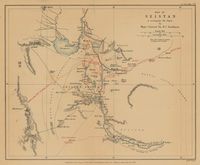
Map of Seistan to accompany the paper by Major-General Sir H. C. Rawlinson. TIFF. London : John Murray, 1873. princeton-mg74qp606. 1873. Rawlinson, Henry, Sir, 1810-1895 and Rawlinson, Henry Creswicke, Sir, 1810-1895. Relief shown by hachures. Area liable to inundation is shown. "The old routes & names of places are in Red." From: The Journal of the Royal Geograp...
Afghānistān, Map Series Index. GeoJSON. Harvard Map Collection. harvard-g7630-s100-a3-index-gr. 1960. Harvard Map Collection, Da Afghānistān Kārtūgrāfī Muʼassasah, and Afghanistan. Vizārat-i Maʻādin va Ṣanāʼiʻ. This polygon is an index to 1:100,000 scale maps of Afghanistan, titled Afghānistān. This map series was originally produced by Da Afghānistān Kār...
Topographic maps of Afghanistan and Kabul. AIMS. stanford-xh132fs5952. 2002. Afghanistan Information Management Service. "Projection geographic." Computer disks include shapes files of Afghanistan and Kabul. CD 1. 34 provinces shapefiles; specific city data including ...
Map of Persia, Afghanistan and Baluchistan. TIFF. [Chicago] : Rand McNally and Co., 1892. princeton-2227ms12b. 1892. Rand McNally and Company. Relief shown by hachures and spot heights. At head of map: Rand, McNally & Co.'s indexed atlas of the world. 522-523. Index on verso.
Province Centers Afghanistan 1995. Shapefile. Afghanistan Information Management Service. tufts-afghanistanprovincecenters95. 1995. Thie point dataset represents the locations of provincial centers in Afghanistan. All (30161) villages' point and names for Afghanistan source (US...