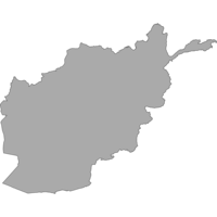
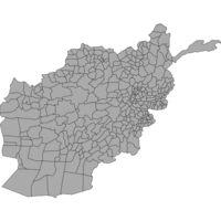
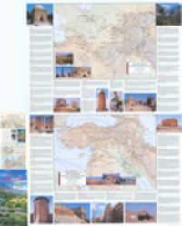
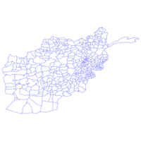
afghanistan
Remove constraint afghanistan
Search Results Header
Search Results
« Previous |
1 - 100 of 173
|
Next »
2. Airports and Airfields Afghanistan 2000

3. Bridges Kabul 2000-2002

4. Country Afghanistan 2002

5. Cultivated Areas Afghanistan 1997

6. Dari Names Kabul 2005

7. District Boundaries: Kandahar, Afghanistan, 2004

8. District Centers Afghanistan 1995

9. Districts Afghanistan 1998

10. Health Facilities Afghanistan 2003

11. International Airports Afghanistan 2000

12. Irrigated Areas Afghanistan 1997

13. Kabul Afghanistan 1995

14. Lakes Afghanistan 1997

15. Landcover Afghanistan 1997

16. Landmarks Kabul 2004

17. Main Roads Afghanistan

18. Population Afghanistan 1997

19. Province Centers Afghanistan 1995

20. Provinces Afghanistan 1998

21. River Region Afghanistan 1997

22. Rivers Afghanistan 1990

23. Roads Afghanistan 1998

24. Settlements Afghanistan 1997

25. Watersheds Afghanistan 2003

26. Betts's new map of India, Birmah, the Punjaub and part of Afghanistan.
27. Persia (Iran), Afghanistan & Baluchistan
28. Afghanistan und seine Nachbarländer
29. Persia and Afghanistan by Keith Johnston, F.R.S.E. Engraved & printed by W. & A.K. Johnston, Edinburgh. William Blackwood & Sons, Edinburgh & London (1861) (Raster Image)

30. Azimuthal equidistant projection centered on Kabul, Afghanistan

31. Ethnolinguistic groups in Afghanistan, 1992

32. The north-west frontier of India
33. Persia, and Afghanistan

34. Boundaries Afghanistan 1986

35. The Kingdome of Persia : with the cheef citties and habites described
36. Central Asia and Afghanistan
37. India, Ceylon & Afghanistan - political
38. Persia and Afghanistan
39. Land Cover Copy Afghanistan 1997
40. Population Gazetteer Afghanistan 1994

41. Afghanistan Major Cities, 1994

42. Afghanistan Major Lakes, 1994

43. Afghanistan Major Rivers, 1994

44. Afghanistan Major Roads, 1994

45. Afghanistan Province Boundaries, 1995

46. Afghānistān, Map Series Index
47. Afghanistan-Pakistan Border Region, 1897 (Raster Image)

48. Central Asia, 1908 (Raster Image)

49. India & South Asia, 1773 (Raster Image)

50. India & South Asia, 1821 (Raster Image)

51. India & South Asia, 1828 (Image 1 of 2) (Raster Image)

52. India & South Asia, 1828 (Image 2 of 2) (Raster Image)

53. India & South Asia, 1850 (Raster Image)

54. Indian Ocean Region, ca. 1690 (Raster Image)

55. Indus River Region, India, Pakistan, and Afghanistan, 1816 (Raster Image)

56. Middle East and South Asia, 1903 (Raster Image)

57. Northwest China and Central Asia, 1750 (Raster Image)

58. Punjab Region, India & Pakistan, 1849 (Raster Image)

59. Punjab Region, India & Pakistan, 1869 (Image 1 of 4) (Raster Image)

60. Punjab Region, India & Pakistan, 1869 (Image 2 of 4) (Raster Image)

61. Punjab Region, India & Pakistan, 1869 (Image 3 of 4) (Raster Image)

62. Punjab Region, India & Pakistan, 1869 (Image 4 of 4) (Raster Image)

63. South & Southeast Asia, 1846 (Raster Image)

64. Anglo Indian Army Movement Map, Afghanistan, 1842 (Raster Image)
65. India, 1788 (Image 3 of 4) (Raster Image)

66. India, 1804 (Image 2 of 6) (Raster Image)

67. Military Staff Map, Central Asia, 1885 (Raster Image)
68. South Asia and Southeast Asia, 1654 (Raster Image)

69. The ancient Silk Road : Afghanistan in context ; an illustrated map featuring the ancient network of routes between China and Europe / production by Twin Age Ltd ; edited by Bijan Omrani, David Chappell & Jeremy Tredinnick ; designed by Au Yeung Chui Kwai ; maps by Mark Stroud, Moon Street Cartography ; main photography, Antonia Tozer.

70. District Line Boundaries, Afghanistan, 2011

71. Districts, Afghanistan, 2011

72. India, Afghanistan, Beloochistan, Burmah and Siam
73. Map of the district between the Oxus River and the Indus River
74. Map of Afghaunistan, Caubul, the Punjab, Rajpootana, and the River Indus
75. Quinta Asie tabula
76. Cabool, the Punjab and Beloochistan
77. Mittel- und Nord-Africa (oestl. Theil) und Arabien
78. City of Herat

79. Map of the North Western Frontier of India, showing the Pamir region and part of Afghanistan

80. The Helmund River

81. The Hindu Kush and passes between the Kabul and Oxus

82. The Sulimani Mountains on the Afghan frontier of British India based on Major Wilson's map, collated with other authorities

83. Map of the country between Sind and Candahar, showing the course of the proposed railway constructed from the recent surveys executed by officers attached to the forces serving in southern Afghanistan, collated with the most authentic material by W. J. Turner

84. Map of the Pishin Valley and upper basin of the Lora constructed from the surveys & reconnaissances executed by officers attached to the forces serving in southern Afghanistan, 1879, collated with Major Wilson's map by W. J. Turner

85. Map of Kafiristan

86. Map of Khorasan, and neighbouring countries illustrating the paper by Lieut. Colonel C. E. Stewart, 5th Punjab Infantry

87. The Tejend oasis and roads to Merv compiled from the latest surveys and information by Colonel Baron Aminof

88. Preliminary map of the routes followed by the members of the Afghan Boundary Commission, by Major T. H. Holdich, R.E.

89. The Heri-Rud & Murghab Rivers and intermediate territory from Merv to Herat : compiled from the survey by the officers of the Afghan Boundary Commission and members of the Russian Military Topographical Department

90. Map of Eastern Persia to illustrate the paper by Major General Sir F. J. Goldsmid

91. Map of Seistan to accompany the paper by Major-General Sir H. C. Rawlinson

92. Map of Central Asia to accompany the paper by Captn. H. Trotter R.E., on the geographical results of Sir T. D. Forsyth's mission to Kashghar, 1873-74

93. Persia

94. Map to illustrate Sir H. Bartle. E. Frere's notes on the Runn of Cutch &c.

95. The Bolor Mountains and upper sources of the Amu Daria explanatory map to article on the Pamir by M. Veniukof

96. Sketch map of Beluchistan and eastern Persia to accompany the papers by Col. F. J. Goldsmid, C. B. and J. W. Barns, Esqre. C.E.

97. Map of the route from Badakshan across the Pamir-Steppe to Kashgar, with the southern branch of the Upper Oxus [cartographic material] : from the survey made by the Mirza in 1868-69, to accompany the paper by Major T. G. Montgomerie, R.E.; F.R.G.S. / [engraved by] Edwd. Weller. (geotiff)
98. Map of the route from Badakshan across the Pamir-Steppe to Kashgar, with the southern branch of the Upper Oxus from the survey made by the Mirza in 1868-69, to accompany the paper by Major T. G. Montgomerie, R.E.; F.R.G.S.

99. Map showing route from Peshawur, through Chitral to Faizabad in Badakshan, from the exploration made by a Sapper Havildar, during 1870 to accompany the paper by Major T. G. Montgomerie, R.E. F.R.G.S.
