Bosnia and Herzegovina, 2002. TIFF. Central Intelligence Agency. princeton-bg257g595. 2002. Central Intelligence Agency. This is a map of Bosnia and Herzogovina. The map was created by the Central Intelligence Agency.
Bosnia and Herzegovina, 1997. TIFF. Central Intelligence Agency. princeton-3x816p06z. 1997. Central Intelligence Agency. This is a map of Bosnia and Herzogovina. The map was created by the Central Intelligence Agency.
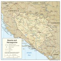
Bosnia and Herzegovina : summary map. TIFF. [Washington, D.C. : Central Intelligence Agency], 1993. princeton-cn69m584s. 1993. United States. Central Intelligence Agency. Relief shown by shading and spot heights. "802127 (R00855) 3-93." Also issued folded to 25 x 14 cm. Includes text, location map, comparative area d...
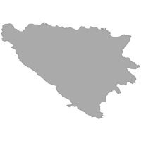
Boundary, Bosnia and Herzegovina, 2015. Shapefile. University of California, Berkeley. Museum of Vertebrate Zoology. stanford-bt512fj0408. 2015. Hijmans, Robert J. and University of California, Berkeley. Museum of Vertebrate Zoology. This polygon shapefile contains the boundary of Bosnia and Herzegovina (adm0). This layer is part of the Global Administrative Areas 2015 (v2.8) da...
Bosnia and Herzegovina, 1992 (with relief). TIFF. Central Intelligence Agency. princeton-f7623f27x. 1992. Central Intelligence Agency. This is a map of Bosnia and Herzogovina with relief. The map was created by the Central Intelligence Agency.
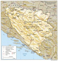
Bosnia and Herzegovina, 1997 (with relief). TIFF. Central Intelligence Agency. princeton-m900nw009. 1997. Central Intelligence Agency. This is a map of Bosnia and Herzogovina with relief. The map was created by the Central Intelligence Agency.
Bosnia and Herzegovina, 1994 (with relief). TIFF. Central Intelligence Agency. princeton-zp38wf22k. 1994. Central Intelligence Agency. This is a map of Bosnia and Herzogovina with relief. The map was created by the Central Intelligence Agency.
Bosnia and Herzegovina, 1997 (no roads). TIFF. Central Intelligence Agency. princeton-tx31qk30c. 1997. Central Intelligence Agency. This is a map of Bosnia and Herzogovina shown at a scale of 1:2,270,000. The map was created by the Central Intelligence Agency.
Bosnien-Herzegowina, Montenegro = Bosnia and Herzegovina, Montenegro = Bosnie-Herzégovine, Monténégro = Bosnia y Herzegovina, Montenegro = Босния и Гервеговина, Черногория. Bielefeld : Reise Know-How Verlag, 2020. princeton-dcbv73cc46f. 2020. Reise Know-How Verlag. Road map. Relief shown by gradient tints and spot heights. Depths shown by bathymetric tints. "Rip & waterproof." "Mit kyrillischer Schrift, Höhenl...
Bosnia and Herzegovina city graphic 1:15,000. Konjic. Series M903. TIFF. Washington, D.C. : [s.n.], 1995. princeton-2801ph949. 1995. Alternate title: Konjic.Transverse Mercator projection. Relief shown by 20 meter contour intervals and spot elevations. This sheet falls within NK ...
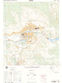
Bosnia and Herzegovina city graphic 1:15,000. Trebinje. Series M903. TIFF. Fairfax, VA : [s.n.], 1995. princeton-6w924d34c. 1995. Alternate title: Trebinje.Transverse Mercator projection. Relief shown by 20 meter contour intervals with supplementary 10 meter contours, and spot...
Bosnia and Herzegovina city graphic 1:15,000. Brcko. Series M903. TIFF. Bethesda, MD : [s.n.], 1995. Reprinted 2001. princeton-m326m3426. 1995. United States. Defense Mapping Agency. Alternate title: Brcko.Transverse Mercator projection. Relief shown by 5 meter contour intervals, and spot e...
Bosnia and Herzegovina city graphic 1:5,000. Orasje. Series M903. TIFF. Fairfax, VA : [s.n.], 1996. princeton-rf55z932b. 1996. Alternate title: Orasje. Transverse Mercator projection.Relief shown by 2 meter contour intervals and spot elevation. This sheet falls within NL 37...
Bosnia and Herzegovina city graphic 1:10,000. Cerska. Series M903. TIFF. Fairfax, VA : [s.n.], 1995. princeton-fx719p16n. 1995. Alternate title: Cerska.Transverse Mercator projection. Relief shown by 20 meter contour intervals with supplementary 10 meter contours, and spot e...
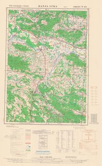
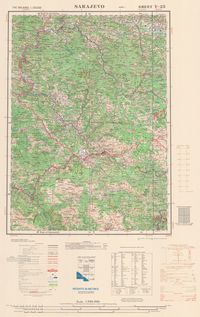
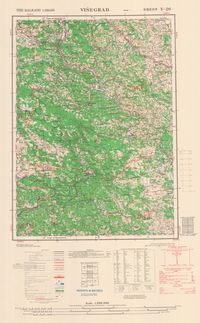
The Balkans 1:250,000. Sarajevo, sheet Y-25. A.M.S. M506 (G.S.G.S. 4413). TIFF. Washington, D.C. : Army Map Service, U.S. Army, 1949. princeton-m900nv94v. 1949. Great Britain. War Office. General Staff. Geographical Section. G.S.G.S. 4413. Alternate title: Sarajevo. Lambert conical orthomorphic projection. ...
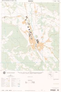
Bosnia and Herzegovina city graphic 1:10,000. Rogatica. Series M903. Bethesda, MD : [s.n.], 1995. princeton-5t34sm28k. 1995. Alternate title: Rogatica. Transverse Mercator projection. Relief shown by 20 meter contour ingervals and spot elevation. This sheet falls within N...
Bosnia and Herzegovina city graphic 1:10,000. Sokolac. Series M903. TIFF. Bethesda, MD : [s.n.], 1995. princeton-f1881n63j. 1995. Alternate title: Sokolac. Transverse Mercator projection. Relief shown by 20 meter contour intervals and spot elevation. This sheet falls within NK...
Bosnia and Herzegovina city graphic 1:15,000. Gorazde. Series M903. TIFF. St. Louis, MS : [s.n.], 1995. princeton-v405sc090. 1995. Alternate title: Gorazde. Transverse Mercator projection. Relief shown by 40 meter contour intervals s and spot elevations. "Coordinate conversion ...
Bosnia and Herzegovina city graphic 1:10,000. Vlasenica. Series M903. TIFF. Fairfax, VA : [s.n.], 1995. princeton-m039k633m. 1995. Alternte title: Vlaseniva.Transverse Mercator projection. Relief shown by 20 meter contour intervals, with 10 meter supplementary contour intervals...
Bosnia and Herzegovina city graphic 1:10,000. Pale. Series M903. TIFF. Bethesda, MD : [s.n.], 2000. princeton-td96k422f. 2000. Alternate title: Pale. Transverse Mercator projection. Relief shown by 20 meter contour intervals with 10 meter supplementary contour intervals, an...
Bosnia and Herzegovina city graphic 1:12,500. Sarajevo. Series M903. TIFF. Bethesda, MD : [s.n.], 1997. princeton-0p096857b. 1997. Alternate title: Sarajevo, sheet 2-This sheet falls within NK 34-1, 1501, 1:250,000 and 2782 I, M709, 1:50,000. Transverse Mercator projection. Rel...
Bosnia and Herzegovina city graphic 1:10,000. Foca. Series M903. TIFF. Bethesda, MD : [s.n.], 1995. princeton-jd472z091. 1995. Alternate title: Foca.Transverse Mercator projection. Relief shown by 20 meter contour intervals with supplementary 10 meter contour lintervals, an...
Heat Flow, Bosnia and Herzegovina, 1991. Shapefile. International Heat Flow Commission. stanford-qs137dr9366. 1991. International Heat Flow Commission, International Association of Seismology and Physics of the Earth's Interior, and Oklahoma State University. Department of Geography. Cartography Service. This point shapefile contains heat flow data for Bosnia and Herzegovina compiled from sources in 1991. Heat flow is a measure of heat loss across t...
Bosnia and Herzegovina (Geographic Feature Names, 2003). Shapefile. United States. National Imagery and Mapping Agency. mit-vhsz5my6xbizm. United States. National Imagery and Mapping Agency. Geographic feature names for Bosnia and Herzegovina.
GAR15 Global Exposure Dataset for Bosnia and Herzegovina. Shapefile. United Nations. Office for Disaster Risk Reduction. stanford-sb551bh6534. 2015. Global Resource Information Database and United Nations. Office for Disaster Risk Reduction. This point shapefile includes estimation on the economic value of the exposed assets in Bosnia and Herzegovina as well as their physical characteri...
Second-level Administrative Divisions, Bosnia and Herzegovina, 2015. Shapefile. University of California, Berkeley. Museum of Vertebrate Zoology. stanford-ws326vw2005. 2015. Hijmans, Robert J. and University of California, Berkeley. Museum of Vertebrate Zoology. This polygon shapefile contains the second-level administrative divisions of Bosnia and Herzegovina (adm2). Level 2 divisions include cantons. This...
Third-level Administrative Divisions, Bosnia and Herzegovina, 2015. Shapefile. University of California, Berkeley. Museum of Vertebrate Zoology. stanford-xt594tq5034. 2015. Hijmans, Robert J. and University of California, Berkeley. Museum of Vertebrate Zoology. This polygon shapefile contains the third-level administrative divisions of Bosnia and Herzegovina (adm3). Level 3 divisions include communes. This...
First-level Administrative Divisions, Bosnia and Herzegovina, 2015. Shapefile. University of California, Berkeley. Museum of Vertebrate Zoology. stanford-nj241sn6981. 2015. Hijmans, Robert J. and University of California, Berkeley. Museum of Vertebrate Zoology. This polygon shapefile contains the first-level administrative divisions of Bosnia and Herzegovina (adm1). Level 1 divisions include districts and ...
Bosnia and Herzegovina city graphic 1:10,000. Bileca. Series M903. TIFF. [S.l.] : Reprinted by National Imagery and Mapping Agency, 1995. princeton-hh63sx75m. 1995. North Decimal Degree 18.450000. South Decimal Degree 18.400. East Decimal Degree 42.900. West Decimal Degree 42.8500. Alternate title:Bileca. Trans...
Bosnia and Herzegovina city graphic 1:12,500. Sarajevo. Series M903. TIFF. Bethesda, MD : [s.n.], 1997. princeton-p2676x28c. 1997. Alternate title: Sarajevo sheet 1.This sheet falls within NK 34-1, 1501A, 1:250,000 and 2782 IV, M709, 1:50,000. Transverse Mercator projection. Re...
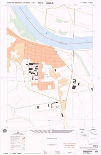
Bosnia and Herzegovina city graphic 1:10,000 : Bijeljina. Series M903. TIFF. Washington, D.C. : [s.n.], 1996. princeton-5h73px51j. 1996. Alternate title: Bijeljina. In upper margin: WGS 84.Transverse Mercator projection. Relief shown by 5 meter contour intervals and spot elevations. ...
Die grenzgebiete Österreich-Ungarns und Serbiens. JPEG 2000. Kartogr. Anstalt G. Freytag & Berndt,. stanford-jt546kj2241. 1912. Freytag, Berndt und Artaria. Druck and Verlag der Kartogr. Anstalt G. Freytag & Berndt, Ges. m. b. H., Wien. Relief shown by shading, spot heights. Greenwich meridian. Lege...
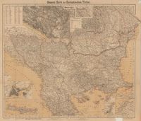
General-Karte der europäischen Türkei / entw. u. gez. v. F. Handtke ; Druck u. Verlag v. C. Flemming. TIFF. Glogau : Verlag von Carl Flemming, [1876]. princeton-dc00000946x. 2013. Handtke, F. (Friedrich), 1815-1879. Relief show by hachures. Prime meridian is Ferro. Includes a list of translated terms used in map.
Turkey and adjacent countires. TIFF. [Place of publication not identified] : [publisher not identified ]; [date of publication not identified]. princeton-dc37720q15k. 1903. Relief shown by hachures and spot heights. Depth shown by sounds in fathoms. Principal meridian is Ferro. Map shows fortresses and forts, cloisters...
Bosnia-Herzegovina Elevations. Shapefile. Gfk MACON Company. princeton-2r36tz98n. 2006. GfK MACON. This data include elevations of Bosnia-Herzegovina created by GfK MACON company, Germany.
Bosnia-Herzegovina Karst Topography. Shapefile. Gfk MACON Company. princeton-xd07gv30r. 2006. GfK MACON. This data includes Bosnia-Herzegovina karst topography created by GfK MACON company, Germany.
Turkey in Europe. JPEG 2000. George Philip & Son,. stanford-vv459yy4235. 1800. Bartholomew, John, 1831-1893 and George Philip & Son. by J. Bartholomew F.R.G.S. Relief shown by hachures and spot heights. Longitudinal and latitudinal lines (Greenwich meridian). Inset map: "Candia o...
Bosnia-Herzegovina Municipality Boundaries, 2005. Shapefile. Gfk MACON Company. princeton-n009w3897. 2006. GfK MACON. This map includes the municipality boundaries of Bosnia-Herzegovina created by GfK MACON company, Germany.
Bosnia-Herzegovina Major Lakes, 2005. Shapefile. Gfk MACON Company. princeton-m613n021f. 2006. GfK MACON. This data include major lakes of Bosnia-Herzegovina created by GfK MACON company, Germany.
Bosnia-Herzegovina Major Airports, 2005. Shapefile. Gfk MACON Company. princeton-m613mz985. 2006. GfK MACON. This data includes Bosnia-Herzegovina major airports created by GfK MACON company, Germany.
Bosnia-Herzegovina Major Railways, 2005. Shapefile. Gfk MACON Company. princeton-9z903126j. 2006. GfK MACON. This data includes Bosnia-Herzegovina major railways created by GfK MACON company, Germany.
Bosnia-Herzegovina Minor Rivers, 2005. Shapefile. Gfk MACON Company. princeton-fq977w496. 2006. GfK MACON. This data include minor rivers of Bosnia-Herzegovina created by GfK MACON company, Germany.