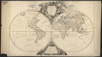
Nicaragua demographic data from 2005 census. Shapefile. princeton-pz50h426r. 2005. East View Geospatial. Official population and housing data for Nicaragua from the 2005 census. This census is provided at the barrio administrative level (ADM4) and incl...
Nicaragua economic data from 2005 census. Shapefile. princeton-6108vk41s. 2005. East View Geospatial. Official population and housing data for Nicaragua from the 2005 census. This census is provided at the barrio administrative level (ADM4) and incl...
Nicaragua housing data from 2005 census. Shapefile. princeton-9s161f32g. 2005. East View Geospatial. Official population and housing data for Nicaragua from the 2005 census. This census is provided at the barrio administrative level (ADM4) and incl...
Nicaragua migration data from 2005 census. Shapefile. princeton-2801pq49z. 2005. East View Geospatial. Official population and housing data for Nicaragua from the 2005 census. This census is provided at the barrio administrative level (ADM4) and incl...
Nicaragua social data from 2005 census. Shapefile. princeton-ff365d41c. 2005. East View Geospatial. Official population and housing data for Nicaragua from the 2005 census. This census is provided at the barrio administrative level (ADM4) and incl...
Nicaragua transportation data from 2005 census. Shapefile. princeton-k643b832z. 2005. East View Geospatial. Official population and housing data for Nicaragua from the 2005 census. This census is provided at the barrio administrative level (ADM4) and incl...
Noua Delineatio Geographica generalis Apostolicarum peregrinationum S FRANCISCI XAUERII Indiarum & Iaponiæ Apostoli in EVROPA, AFRICA, ASIA & in Mari AMERICÆ [:] Nieuwe generaele Verbeeldinghe van de Apostelÿcke pelgrimagien vanden H FRANCISCVS XAVERIVS Apostel van Indien ende Iaponien in EVROPA, AFRICA, ASIA, ende ter Zee in AMERICA. JPEG 2000. stanford-cm586dt8501. 1663. Bouttats, Frederik, ca. 1620-1676. Map centers on Eastern Hemisphere and includes Longitudes between 330 deg. West and 230 deg. East and Latitudes between 60 deg North and South, thu...
Novissima et Accuratissima TOTIUS AMERICÆ DESCRIPTIO. JPEG 2000. stanford-sk402kh8074. 1671. Ogilby, John, 1600-1676. Engraved by: F. Lamb, Sculp (lower right). Wagner 404; Tooley 35 (Plate 42). Place names in Latin. Based on Visscher map; California as an island w...
Orbis vetus in utrâque continente: juxta mentem Sansonianam distinctus, nec non observationibus astronomicis redactus, accurante; Robert de Vaugondy, geographo regis ordinario. JPEG. a47488d7-26be-4b1c-a4af-4383951e6991. 1752. Robert de Vaugondy, Gilles, 1688-1766.,Boudet, Antoine, 1715?-1787 engraver.,Dahl, James, former owner. Relief shown pictorially. Includes two latin inscriptions about the author and mapseller. Also includes a decorative cartouche framed by an angel a...
Paraguay demographic data from 2002 census. Shapefile. princeton-4q77g051w. 2002. East View Geospatial. Official population and housing data for Paraguay from the 2002 census. This census is provided at the manzana administrative level (ADM6) and incl...
Paraguay economic data from 2002 census. Shapefile. princeton-h128nn86b. 2002. East View Geospatial. Official population and housing data for Paraguay from the 2002 census. This census is provided at the manzana administrative level (ADM6) and incl...
Paraguay housing data from 2002 census. Shapefile. princeton-rf55zg853. 2002. East View Geospatial. Official population and housing data for Paraguay from the 2002 census. This census is provided at the manzana administrative level (ADM6) and incl...
Paraguay migration data from 2002 census. Shapefile. princeton-w6634b79g. 2002. East View Geospatial. Official population and housing data for Paraguay from the 2002 census. This census is provided at the manzana administrative level (ADM6) and incl...
Paraguay social data from 2002 census. Shapefile. princeton-mp48sm931. 2002. East View Geospatial. Official population and housing data for Paraguay from the 2002 census. This census is provided at the manzana administrative level (ADM6) and incl...
Paraguay transportation data from 2002 census. Shapefile. princeton-0z709461n. 2002. East View Geospatial. Official population and housing data for Paraguay from the 2002 census. This census is provided at the manzana administrative level (ADM6) and incl...
Peru demographic data from 2007 census. Shapefile. princeton-70795g80r. 2007. East View Geospatial. Official population and housing data for Peru from the 2007 census. This census is provided at the district administrative level (ADM3) and include...
Peru economic data from 2007 census. Shapefile. princeton-br86bb72k. 2007. East View Geospatial. Official population and housing data for Peru from the 2007 census. This census is provided at the district administrative level (ADM3) and include...
Peru housing data from 2007 census. Shapefile. princeton-gh93h6673. 2007. East View Geospatial. Official population and housing data for Peru from the 2007 census. This census is provided at the district administrative level (ADM3) and include...
Peru migration data from 2007 census. Shapefile. princeton-m900p258v. 2007. East View Geospatial. Official population and housing data for Peru from the 2007 census. This census is provided at the district administrative level (ADM3) and include...
Peru social data from 2007 census. Shapefile. princeton-37720m89d. 2007. East View Geospatial. Official population and housing data for Peru from the 2007 census. This census is provided at the district administrative level (ADM3) and include...
Puerto Limon, Central America (AMS E501), 1:250000. GeoJPEG. utaustin_19095. Scale: 1:250000; Map Type: Topographic maps; Other Descriptive Notes about Map Series: E501.. Transverse Mercator projection. Compiled from var...
San Jose C 16 S, Central America (AMS E501), 1:250000. GeoJPEG. utaustin_19097. Scale: 1:250000; Map Type: Topographic maps; Other Descriptive Notes about Map Series: E501.. Transverse Mercator projection. Compiled from var...
San Pedro Del Norte D 16 S, Central America (AMS E501), 1:250000. GeoJPEG. utaustin_72502. Scale: 1:250000; Map Type: Topographic maps; Other Descriptive Notes about Map Series: E501.. Transverse Mercator projection. Compiled from var...
TOTIVS AMERICÆ NOVA ET EXACTA TABVLA EX OPTIMIS TVM GEOGRAPHORVM, TVM ALIORVM | SCRIPTIS COLLECTA, ET AD HODIERNAM REGNORVM PRINCIPATVVM, ET MAI[?]RVM PARTIVM DISTINCTIONEM ACCOMMODATA PER CORN. DANKERVM |[=] CARTE NOVVELLE ET EXACTE DE L'AMERIQVE NOVVELLEMENT DRESSEE SVR LES MEMOIRES | DES MEILLEURS GEOGRAPHES ET AVTRES ESCRIVAINS DE NOSTRE TEM [ ... ?] ET PRINCIPALES PARTIES QVY SY TROVVENT A PRESENT. JPEG 2000. stanford-tf486tz1347. 1647. Per Corn. Dankervm, Mariette, Pierre, Mariette, Pierre (ca. 1602-53), Danckerts, Cornelius, the younger (1664-1717), and Duval [Du Val], Pierre (1618-83). Referred to as “old ugly.” Framed on the wall in the basement hallway. Title in Latin and French.California as an island with flat northern coast....
Trujillo D 16 N, Central America (AMS E501), 1:250000. GeoJPEG. utaustin_19102. Scale: 1:250000; Map Type: Topographic maps; Other Descriptive Notes about Map Series: E501.. Transverse Mercator projection. Compiled from var...
Uruguay demographic data from 2011 census. Shapefile. princeton-6395wg258. 2011. East View Geospatial. Official population and housing data for Uruguay from the 2011 census. This census is provided at the census tract administrative level (ADM3) and ...
Uruguay economic data from 2011 census. Shapefile. princeton-2b88qm34p. 2011. East View Geospatial. Official population and housing data for Uruguay from the 2011 census. This census is provided at the census tract administrative level (ADM3) and ...
Uruguay housing data from 2011 census. Shapefile. princeton-q237j111w. 2011. East View Geospatial. Official population and housing data for Uruguay from the 2011 census. This census is provided at the census tract administrative level (ADM3) and ...
Uruguay migration data from 2011 census. Shapefile. princeton-9s161f33z. 2011. East View Geospatial. Official population and housing data for Uruguay from the 2011 census. This census is provided at the census tract administrative level (ADM3) and ...
Uruguay social data from 2011 census. Shapefile. princeton-fj236926h. 2011. East View Geospatial. Official population and housing data for Uruguay from the 2011 census. This census is provided at the census tract administrative level (ADM3) and ...
Uruguay transportation data from 2011 census. Shapefile. princeton-k930c5205. 2011. East View Geospatial. Official population and housing data for Uruguay from the 2011 census. This census is provided at the census tract administrative level (ADM3) and ...
U.S. Census Tracts, 2013. Shapefile. princeton-g732db55s. 2011. TomTom North America, Inc. U.S. Census Tracts represents the U.S. Census tracts of the United States in the 50 states, the District of Columbia, and Puerto Rico.
Venezuela demographic data from 2011 census. Shapefile. princeton-2227mx843. 2011. East View Geospatial. Official population and housing data for Venezuela from the 2011 census. This census is provided at the parroquias administrative level (ADM3) and ...
Venezuela economic data from 2011 census. Shapefile. princeton-x920g504f. 2011. East View Geospatial. Official population and housing data for Venezuela from the 2011 census. This census is provided at the parroquias administrative level (ADM3) and ...
Venezuela housing data from 2011 census. Shapefile. princeton-sj139913v. 2011. East View Geospatial. Official population and housing data for Venezuela from the 2011 census. This census is provided at the parroquias administrative level (ADM3) and ...
Venezuela migration data from 2011 census. Shapefile. princeton-ns064f228. 2011. East View Geospatial. Official population and housing data for Venezuela from the 2011 census. This census is provided at the parroquias administrative level (ADM3) and ...
Venezuela social data from 2011 census. Shapefile. princeton-db78tm211. 2011. East View Geospatial. Official population and housing data for Venezuela from the 2011 census. This census is provided at the parroquias administrative level (ADM3) and ...
Venezuela transportation data from 2011 census. Shapefile. princeton-j098zk30x. 2011. East View Geospatial. Official population and housing data for Venezuela from the 2011 census. This census is provided at the parroquias administrative level (ADM3) and ...