Digital Maps and Geospatial Data | Princeton University

latin america census el salvador Remove constraint latin america census el salvador

Search Results Header

Search Results

Number of results to display per page

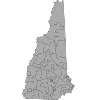
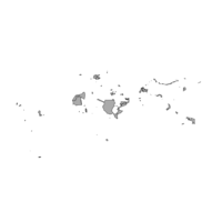
401. House Floterial District Boundaries New Hampshire 2012

Polygon Tufts University Public content House Floterial District Boundaries New Hampshire 2012 . Shapefile. NH GRANIT (Firm). tufts-nhhousefloterialdistricts12. 2012. This polygon dataset shows the New Hampshire House of Representatives "floterial" district boundaries drawn by the New Hampshire Legislature based ...

402. Navigatio ac itinerarium Iohannis Hugonis Linscotani in orientalem sive Lusitanorum Indiam, descriptiones eiusdem terræ ac tractuum littoralium

Image Stanford University Public content Navigatio ac itinerarium Iohannis Hugonis Linscotani in orientalem sive Lusitanorum Indiam, descriptiones eiusdem terræ ac tractuum littoralium. JPEG 2000. Veneunt apud Iohannem Walschaert,. stanford-jh359kq7869. 1614. Linschoten, Jan Huygen van, 1563-1611, Walschaert, Hans, active 1614-1636, Doetichum, Johan van, the elder, -1600, Doetichum, Johan van, the younger, active 1592-1630, Doetichum, Baptista van, -1611, and Langren, Arnold Florent van, 1580-1644. Abridged Latin translation of Itinerario, voyage ofte schipvaert, Amsterdam, Cornelis Claesz, 1596; Latin translation originally published in the H...

403. Gulf of Mexico and Caribbean Sea Region, ca. 1715 (Raster Image)

Raster Harvard University Public content Gulf of Mexico and Caribbean Sea Region, ca. 1715 (Raster Image). GeoTIFF. Harvard Map Collection, Harvard Library. harvard-g4390-1715-m6. 1715. Harvard Map Collection, Harvard College Library and Moll, Herman, d. 1732. This layer is a georeferenced raster image of the historic paper map entitled: A map of the West-Indies or the islands of America in the North Sea ...

404. Western Hemisphere, 1740 (Image 1 of 2) (Raster Image)

Raster Harvard University Public content Western Hemisphere, 1740 (Image 1 of 2) (Raster Image). GeoTIFF. Harvard Map Collection, Harvard College Library. harvard-g3290-1740-l4-sheet-1. 1740. Harvard Map Collection, Harvard College Library, Harvard University. Library. Open Collections Program, Leth, Andries de, 1662-1731., and Leth, Hendrik de, 1703-1766. This layer is a georeferenced raster image of the historic paper map entitled: Carte nouvelle de la mer du Sud : dressee par ordre des principaux d...

405. Western Hemisphere, 1740 (Image 2 of 2) (Raster Image)

Raster Harvard University Public content Western Hemisphere, 1740 (Image 2 of 2) (Raster Image). GeoTIFF. Harvard Map Collection, Harvard College Library. harvard-g3290-1740-l4-sheet-2. 1740. Harvard Map Collection, Harvard College Library, Harvard University. Library. Open Collections Program, Leth, Andries de, 1662-1731., and Leth, Hendrik de, 1703-1766. This layer is a georeferenced raster image of the historic paper map entitled: Carte nouvelle de la mer du Sud : dressee par ordre des principaux d...

406. Chile communes, 2017 (Comuna)

Princeton University Restricted content Chile communes, 2017 (Comuna). Shapefile. princeton-k0698c50d. 2017. Chile, National Institute of Statistics/Instituto Nacional de Estadísticas. The communes may have urban, rural or mixed characteristics. In the territory of a commune there may be more than one urban center, be it a city (m...

407. Mapa de la Isla de Cuba : indicando la geografía física y política y tambien las grandes lineas de communicacion

Princeton University Public content Mapa de la Isla de Cuba : indicando la geografía física y política y tambien las grandes lineas de communicacion. TIFF. En Paris ; New York: Turgis Jne. editeur, Rue des Ecoles, 60 ... ; [1851?] (Paris : Delarue, Impr.). princeton-8w32r792g. 1851. Vuillemin, A. (Alexandre), 1812-. Relief shown by hachures. Includes Inset maps: Plano de La Habana -- Mapa indicando el curso de los buques de vapor -- Isla de Puertorico. Includes...

408. [world]

Image Stanford University Public content [world]. JPEG 2000. stanford-nm595xv6478. 1606. García de Céspedes, Andrés, d. 1611. Simple untitled world map consisting of twelve globe gores. California is not shown as an island, and the entire west coast of South America is rem...

409. Chile regions, 2017 (Region)

Princeton University Restricted content Chile regions, 2017 (Region). Shapefile. princeton-s4655m59p. 2017. Chile, National Institute of Statistics/Instituto Nacional de Estadísticas. The Region is the territory organized around a central place with relatively homogeneous spatial physical characteristics, with a greater subnation...

410. Bay of All Saints, Bahia, Brazil, ca. 1710 (Raster Image)

Raster Harvard University Public content Bay of All Saints, Bahia, Brazil, ca. 1710 (Raster Image). GeoTIFF. Harvard Map Collection, Harvard Library. harvard-g5562-a4-1710-m6. 1710. Harvard Map Collection, Harvard Library and Mortier, Pierre. This layer is a georeferenced raster image of the historic paper map entitled: Sinus omnium sanctoru[m]. It was published by the workshop of P. Mor...

411. Tabularum geographicarum contractarum libri quatuor

Image Stanford University Public content Tabularum geographicarum contractarum libri quatuor. JPEG 2000. Cornelium Nicolai. stanford-qv774nk8098. 1600. Bertius, Petrus, 1565-1629, Claesz, Cornelis, approximately 1546-1609, Jansson, Jan, 1588-1664, Hondius, Jodocus, 1563-1612, and Keere, Pieter van den, 1571-approximately 1646. P Bertii. Errata on p. [646]. Engraved t.p. with navigators, cosmographers at table and America & ship in background. Verso depicts Magellan's ...

412. Atlas minor

Image Stanford University Public content Atlas minor. JPEG 2000. excudebat Adrianus Bottius,. stanford-ph334yx8290. 1610. Mercator, Gerhard, 1512-1594, Hondius, Jodocus, 1563-1612, Hondius, Jodocus, 1594 or 1595-1629, Jansson, Johannes, and Bottius, Adrianus. Gerardi Mercatoris à I. Hondio plurimis æneis tabulis auctus atque illustratus ; Amsterodami: excusum in ædibus Iudoci Hondii, veneunt etiam apud C...

413. Tabula geographica nova omnium oculis exibens et proponens verissimam descriptionem potentissimi et aurifen Regni Guiana

Image Stanford University Public content Tabula geographica nova omnium oculis exibens et proponens verissimam descriptionem potentissimi et aurifen Regni Guiana. JPEG 2000. M. Becker]. stanford-qw352zt9270. 1599. Hondius, Jodocus, 1563-1612, Bry, Theodor de, 1528-1598, Becker, Matthias, active 1573-1606, and Raleigh, Walter, Sir, 1552?-1618. siti per nautam aliguem qui Gualthero Ralegh navigatione semper adsuit delineata. Relief shown pictorially. Decorative cartouches, compass roses, r...

414. Gulf of Suez and Sinai Peninsula, 1772 (Raster Image)

Raster Harvard University Public content Gulf of Suez and Sinai Peninsula, 1772 (Raster Image). GeoTIFF. Harvard Map Collection, Harvard Library. harvard-g8302-s52-1772-n5. 1772. Harvard Map Collection, Harvard Library, Niebuhr, Carsten, 1733-1815, and Defehrt, A. J. This layer is a georeferenced raster image of the historic paper map entitled: Tabula itineraria a Sues usque ad Dsjäbbel el Mokátteb et Montem Sin...

415. Cibola County, New Mexico roads, 2014

Princeton University Restricted content Cibola County, New Mexico roads, 2014. Shapefile. princeton-tx31qn109. 2014. U.S. Department of Commerce, U.S. Census Bureau, Geography Division, Geographic Products Branch. Roads and highways in Cibola County, New Mexico, 2014. The TIGER/Line shapefiles and related database files (.dbf) are an extract of selected geogr...

416. Cuba Insula

Image Stanford University Public content Cuba Insula. JPEG 2000. Jodocus Hondius. stanford-jc686tb6436. 1613. Mercator, Gerard, approximately, 1565-1656 and Hondius, Jodocus, 1563-1612. Relief shown pictorially. Prime meridian: [Ferro]. Latitudinal and longitudinal lines along margins. Decorative cartouches, ships, sea monsters. Sh...

417. Congressional Districts for 107th Congress United States 2001

Polygon Tufts University Public content Congressional Districts for 107th Congress United States 2001. Shapefile. Geological Survey (U.S.). tufts-uscongdist107th01. 2001. This polygon dataset represents the Congressional Districts of the United States for the 107th Congress. The data set was created by extracting li...

418. Chile hamlet boundaries, 2017 (Limite Aldea)

Princeton University Restricted content Chile hamlet boundaries, 2017 (Limite Aldea). Shapefile. princeton-f7623h58k. 2017. Chile, National Institute of Statistics/Instituto Nacional de Estadísticas. Defined areas for the precensus survey that recognize hamlet-type entities, made up of blocks with the characteristics of urban locations.[Áreas de...

419. World distribution of spirochetal diseases: 1.Yaws, pinta, bejel

Princeton University Restricted content World distribution of spirochetal diseases: 1.Yaws, pinta, bejel. TIFF. New York, NY : American Geographical Society, 1955. princeton-5999n5195. 1955. American Geographical Society of New York. Briesemeister elliptical equal-area projection. On upper right margin: Atlas of distribution of diseases...

420. Correctional Institution Locations New Hampshire 2006-2009

Point Tufts University Public content Correctional Institution Locations New Hampshire 2006-2009. Shapefile. NH GRANIT (Firm). tufts-nhcorrectionalinstitutions0609. 2008. This point dataset shows correctional institutions in New Hampshire. Jails and Prisons (Correctional Institutions). The Jails and Prisons sub-laye...

421. MEXIQVE ou N.LE ESPAGNE

Image Stanford University Public content MEXIQVE ou N.LE ESPAGNE. JPEG 2000. stanford-dq232gc5337. 1661. Duval, P. (Pierre), 1619-1682. Title in French. California unlabelled. M. de Californie to its east Issued in his: Geographie Universelle. -- Paris, ca.1661. Title in Latin: MEXI...

422. Gulf of Mexico and Caribbean Sea Region, 1774 (Image 1 of 2) (Raster Image)

Raster Harvard University Public content Gulf of Mexico and Caribbean Sea Region, 1774 (Image 1 of 2) (Raster Image). GeoTIFF. Harvard Map Collection, Harvard Library. harvard-g4390-1774-s6-sh1. 1774. Harvard Map Collection, Harvard College Library, Speer, Joseph Smith., and Bowen, Thomas, -1790. This layer is a georeferenced raster image of the historic paper map entitled: To His Royal Highness. George Augustus Frederick. Prince of Wales &c...

423. Gulf of Mexico and Caribbean Sea Region, 1774 (Image 2 of 2) (Raster Image)

Raster Harvard University Public content Gulf of Mexico and Caribbean Sea Region, 1774 (Image 2 of 2) (Raster Image). GeoTIFF. Harvard Map Collection, Harvard Library. harvard-g4390-1774-s6-sh2. 1774. Harvard Map Collection, Harvard College Library, Speer, Joseph Smith., and Bowen, Thomas, -1790. This layer is a georeferenced raster image of the historic paper map entitled: To His Royal Highness. George Augustus Frederick. Prince of Wales &c...

424. Gulf of Mexico and Caribbean Sea Region, 1779-1782 (Image 1 of 2) (Raster Image)

Raster Harvard University Public content Gulf of Mexico and Caribbean Sea Region, 1779-1782 (Image 1 of 2) (Raster Image). GeoTIFF. Harvard Map Collection, Harvard Library. harvard-g4390-1779-r6-sh1. 1779. Harvard Map Collection, Harvard College Library and Robert Sayer and John Bennett (Firm). This layer is a georeferenced raster image of the historic paper map entitled: A new general chart of the West Indies : from the latest marine jour...

425. Gulf of Mexico and Caribbean Sea Region, 1779-1782 (Image 2 of 2) (Raster Image)

Raster Harvard University Public content Gulf of Mexico and Caribbean Sea Region, 1779-1782 (Image 2 of 2) (Raster Image). GeoTIFF. Harvard Map Collection, Harvard Library. harvard-g4390-1779-r6-sh2. 1779. Harvard Map Collection, Harvard College Library and Robert Sayer and John Bennett (Firm). This layer is a georeferenced raster image of the historic paper map entitled: A new general chart of the West Indies : from the latest marine jour...

426. Chile provinces, 2017 (Provincia)

Princeton University Restricted content Chile provinces, 2017 (Provincia). Shapefile. princeton-ws859k66c. 2017. Chile, National Institute of Statistics/Instituto Nacional de Estadísticas. Provinces are the units into which a region is administratively divided, with a characteristic productive destination and cultural identity (techni...

427. Voter Data per State United States 2000 - 2008

Polygon Tufts University Public content Voter Data per State United States 2000 - 2008. Shapefile. Geological Survey (U.S.). tufts-usvoterperstate0008. 2000. This polygon dataset shows the US percentage of voting age persons registered to vote and voted, per State for 2000-2008. Data is expressed in perc...

428. [Celestial charts and world maps]

Image Stanford University Public content [Celestial charts and world maps]. JPEG 2000. s.n. stanford-qg633rp8719. 1700. Includes 7 figures, with a large celestial chart in the center labeled Fig B. California as an island shown in Figures I and D, which are hemispher...

429. Gulf of Mexico and Caribbean Sea Region, 1717 (Raster Image)

Raster Harvard University Public content Gulf of Mexico and Caribbean Sea Region, 1717 (Raster Image). GeoTIFF. Harvard Map Collection, Harvard Library. harvard-g4390-1717-f4. 1717. Harvard Map Collection, Harvard College Library, Fer, Nicolas de, 1646-1720., and Starckman, P. This layer is a georeferenced raster image of the historic paper map entitled: Le Golfe de Mexique : et les provinces et isles qui l'environe comme...

430. Cities and Towns 1:1,000,000 Scale United States, Puerto Rico, and Virgin Islands 2014

Point Tufts University Public content Cities and Towns 1:1,000,000 Scale United States, Puerto Rico, and Virgin Islands 2014. Shapefile. Geological Survey (U.S.). tufts-uscitiestowns1mil14. 2014. This point dataset represents cities and towns in the United States, Puerto Rico, and the U.S. Virgin Islands with data from the 2010 census. A ci...

431. [World map]

Image Stanford University Public content [World map]. JPEG 2000. Johann Christoph Weigel. stanford-qh664hf2573. 1719. Doppelmayr, Johann Gabriel, 1677-1750. California shown as an unlabeled island with a very indented western coast. Hemispheres are tilted at a 45 degree angle toward the center. Includes...

432. Chile precensus blocks, 2017 (Manzana Precensal)

Princeton University Restricted content Chile precensus blocks, 2017 (Manzana Precensal). Shapefile. princeton-th83m333t. 2017. Chile, National Institute of Statistics/Instituto Nacional de Estadísticas. A block is a territorial unit used for statistical purposes, preferably delimited by streets, property boundaries, or, failing that, watercourses a...

433. Orbis vetus, et orbis veteris utraque continens, terrarum q3 tractus Arcticus, et Antarcticus

Image Stanford University Public content Orbis vetus, et orbis veteris utraque continens, terrarum q3 tractus Arcticus, et Antarcticus. JPEG 2000. Apud P. Mortier. stanford-fm706sb1090. 1705. Sanson, Nicolas, 1600-1667, Mortier, Pierre, 1661-1711, and Cóvens et Mortier. Auctore N. Sanson Abbavillaeo, et Christianiss. Galliar Regis Geographo. California shown as an unlabeled island with flat northern coast. Depicts ...

434. Orbis vetus, et orbis veteris utraque continens, terrarum q3 tractus Arcticus, et Antarcticus

Image Stanford University Public content Orbis vetus, et orbis veteris utraque continens, terrarum q3 tractus Arcticus, et Antarcticus. JPEG 2000. Apud P. Mortier. stanford-qx771kk2987. 1705. Sanson, Nicolas, 1600-1667, Mortier, Pierre, 1661-1711, and Cóvens et Mortier. Auctore N. Sanson Abbavillaeo, et Christianiss. Galliar Regis Geographo. California shown as an unlabeled island with flat northern coast. Depicts ...

435. Orbis terrarum typus

Image Stanford University Public content Orbis terrarum typus. JPEG 2000. s.n. stanford-dy019kj1197. 1700. Clüver, Philipp, 1580-1622. California shown as a labeled island with a slightly indented northern coast and a few place names. Shows a wide strait to the NW of California. An...

436. Orbis terrarum typus

Image Stanford University Public content Orbis terrarum typus. JPEG 2000. s.n. stanford-cm303hd3051. 1700. Clüver, Philipp, 1580-1622. California shown as a labeled island with a slightly indented northern coast and a few place names. Shows a wide strait to the NW of California. An...

437. Mapemonde planisphere ou carte generale du monde

Image Stanford University Public content Mapemonde planisphere ou carte generale du monde. JPEG 2000. s.n. stanford-wb781xz8377. 1710. Baeck, Elias 1679-1747. California as an island with a narrowing northern end. Portion of northwestern continent above California is left blank. Antartic land mass almost ...

438. New England and Middle Atlantic States, ca. 1730 (Raster Image)

Raster Harvard University Public content New England and Middle Atlantic States, ca. 1730 (Raster Image). GeoTIFF. Harvard Map Collection, Harvard College Library. harvard-g3720-1730-s4. 1730. Harvard Map Collection, Harvard College Library and Seutter, Matthaeus, 1678-1756. This layer is a georeferenced raster image of the historic paper map entitled: Recens edita totius Novi Belgii in America Septentrionali siti, deli...

439. Coasts, Brazil, 1830 (Raster Image)

Raster Harvard University Public content Coasts, Brazil, 1830 (Raster Image). GeoTIFF. Harvard Map Collection, Harvard College Library. harvard-g5401-c6-1830-r2. 1830. Harvard Map Collection, Harvard College Library, R. Blachford & Co., Patriceo, Jose., and Pimental, Manoel. This layer is a georeferenced raster image of the historic paper map entitled: Blachford & Co.'s new chart of the coast of Brazil : from the Equato...

440. Tartariae Imperium

Image Stanford University Public content Tartariae Imperium. JPEG 2000. Apud Haeredes Simonis Galignani de Karera,. stanford-pm323nt1979. 1596. Magini, Giovanni Antonio, 1555-1617 and Porro, Girolamo, 1520-1604. Giovanni Antonio Magini. From the 1596 atlas : Geographiae universae tum veteris tum novae absolutissimum opus duobus voluminibus distinctum, in qu...

441. Gulf of Mexico and Caribbean Sea Region, ca. 1708 (Raster Image)

Raster Harvard University Public content Gulf of Mexico and Caribbean Sea Region, ca. 1708 (Raster Image). GeoTIFF. Harvard Map Collection, Harvard Library. harvard-g4390-1708-o8. 1708. Harvard Map Collection, Harvard Library, Ottens, R. (Reiner), 1698-1750., Ottens, J. (Josua), 1704-1765., and R. & J. Ottens. This layer is a georeferenced raster image of the historic paper map entitled: Nova Isthmi Americani, qui et Panamiensis item Dariensis, tabula, in...

442. California Regional Transportation Planning Agencies, 2013

Polygon Stanford University Public content California Regional Transportation Planning Agencies, 2013. Shapefile. California. Department of Transportation. stanford-rw871gr7791. 2013. California. Department of Transportation. This polygon shapefile contains the boundaries of California Regional Transportation Planning Agencies (RTPA) as of February, 2014. These data were...

443. Combined Statistical Areas United States and Puerto Rico 2013

Polygon Tufts University Public content Combined Statistical Areas United States and Puerto Rico 2013. Shapefile. Geological Survey (U.S.). tufts-uscsa13. 2013. This polygon dataset represents Combined Statistical Areas in the United States and Puerto Rico. Combined statistical areas consist of two or more...

444. Gulf of Mexico and Caribbean in 1654 (Raster Image)

Raster Harvard University Public content Gulf of Mexico and Caribbean in 1654 (Raster Image). GeoTIFF. Harvard Map Collection, Harvard Library. harvard-g1059-w57-1654-pf-sh14. 1654. Harvard Map Collection, Harvard Library, Jacobsz, Theunis, 1632?-1679., and Wit, Frederik de. This layer is a georeferenced raster image of the historic paper map entitled: Pascaerte van West Indien : van de Caribes tot aen de Golfo van Mexi...

445. U.S. Neighborhoods greenness measures and social variables

Polygon Stanford University Public content U.S. Neighborhoods greenness measures and social variables. Shapefile. Stanford Digital Repository. stanford-xq082nw3443. 2000. Grossner, Karl, 1950-, Alvarez, Noemi, Christensen, Jon, and Trust for Public Land (U.S.). This polygon shapefile includes neighborhood boundaries supplied by Zillow.com, the Los Angeles Times and the City of Denver, and variables related...

446. Ciudad Juarez, Mexico (AMS F401), 1:500000

Raster The University of Texas at Austin Public content Ciudad Juarez, Mexico (AMS F401), 1:500000. GeoJPEG. utaustin_19329. Scale: 1:500000; Relief Symbology: contours, gradient and bathymetric tints; Other Descriptive Notes about Map Series: [U.S. Army Map Service. ...

447. Cities and Towns 1:2,000,000 Scale United States and Virgin Islands 1972-2004

Point Tufts University Public content Cities and Towns 1:2,000,000 Scale United States and Virgin Islands 1972-2004. Shapefile. Geological Survey (U.S.). tufts-uscitiestowns2mil7204. 1972. This point dataset represents cities in the United States, Puerto Rico and the U.S. Virgin Islands, collected from the 1970 National Atlas of the U...

448. Mapping Interstate Territorial Conflict, 1947-2000 (v2)

Polygon Stanford University Public content Mapping Interstate Territorial Conflict, 1947-2000 (v2). Shapefile. Stanford Digital Repository. stanford-jn766dx6840. 2019. Schultz, Kenneth A. This polygon shapefile represents areas that were the subject of interstate territorial disputes between 1947 and 2000. The disputed areas referenc...

449. Mexicali Ni, Mexico (AMS F401), 1:500000

Raster The University of Texas at Austin Public content Mexicali Ni, Mexico (AMS F401), 1:500000. GeoJPEG. utaustin_19335. Scale: 1:500000; Relief Symbology: contours, gradient and bathymetric tints; Other Descriptive Notes about Map Series: [U.S. Army Map Service. ...

450. AUDIENCE DE GUADALAJARA, NOUVEAU MEXIQUE, CALIFORNIE, &c.

Image Stanford University Public content AUDIENCE DE GUADALAJARA, NOUVEAU MEXIQUE, CALIFORNIE, &c. JPEG 2000. Chez P. Mariette. stanford-kc128tv5108. 1656. Sanson, Nicolas, 1600-1667. [1656], in French, with imprint 'A Paris chez P. Mariette rue S. Iacques a l'Esperance Avec Pri. pour 20 ans'. Manuscript '63' (top right, outside ...

451. Core Based Statistical Areas United States and Puerto Rico 2010

Polygon Tufts University Public content Core Based Statistical Areas United States and Puerto Rico 2010. Shapefile. Geological Survey (U.S.). tufts-uscbsa10. 2013. This polygon datasets portrays core based statistical areas in the United States and Puerto Rico in 2010. The map layer was created from the CENSU...

452. Built Up Locations United States, Puerto Rico, and the U.S. Virgin Islands 2010

Point Tufts University Public content Built Up Locations United States, Puerto Rico, and the U.S. Virgin Islands 2010. Shapefile. Geological Survey (U.S.). tufts-usbuiltuplocations10. 1972. This point dataset includes Global Map data showing built up areas, primarily cities and towns, in the United States, Puerto Rico, and the U.S. Vir...

454. Ecuador Toponyms

Point The University of Texas at Austin Public content Ecuador Toponyms. Shapefile. utaustin_121140. This shapefile is comprised of toponymic data generated from topographic maps (1:50,000) of Ecuador’s Oriente - a region which is defined by the tr...

455. Geographic Names: San Francisco Bay Area, California, 2006

Point Stanford University Public content Geographic Names: San Francisco Bay Area, California, 2006. Shapefile. Bay Area Open Space Council. stanford-gq515vq0921. 2006. Bay Area Open Space Council, Conservation Lands Network, San Francisco Bay Area Upland Habitat Goals Project, and GreenInfo Network (Firm). This point shapefile depicts physical and cultural geographic features of all types, not including roads and highways, within the nine county San F...

456. United States National Park System, 2013

Polygon Columbia University Public content United States National Park System, 2013. Shapefile. sde-columbia-ntad_2013_parks. 2011. United States. Bureau of Transportation Statistics and United States. National Park Service. United States National Park System, 2013 is a polygon theme representing the National Park System.