Digital Maps and Geospatial Data | Princeton University

Search Results Header

Search Results

Number of results to display per page

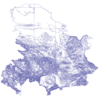
1. Mapping Interstate Territorial Conflict, 1947-2000 (v2)

Polygon Stanford University Public content 
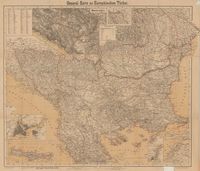
Mapping Interstate Territorial Conflict, 1947-2000 (v2). Shapefile. Stanford Digital Repository. stanford-jn766dx6840. 2019. Schultz, Kenneth A. This polygon shapefile represents areas that were the subject of interstate territorial disputes between 1947 and 2000. The disputed areas referenc...

2. Beograd : Plan grad - city map / map design & publishing Gizi Map.

Princeton University Restricted content Beograd : Plan grad - city map / map design & publishing Gizi Map. Novi Beograd : Magic Map d.o.o., 2018. princeton-dc5m60r472n. 2018. Radovanović, Slobodan and Magic Map (Firm). Relief shown by spot heights. Title from panel. At head of panel title: Magic Map. Includes text, ancillary suburb map, ancillary "Parking zone" ci...

3. Heat Flow, Serbia, 1991-2008

Point Stanford University Public content Heat Flow, Serbia, 1991-2008. Shapefile. International Heat Flow Commission. stanford-mk456dj0487. 2016. International Heat Flow Commission, International Association of Seismology and Physics of the Earth's Interior, and Oklahoma State University. Department of Geography. Cartography Service. This point shapefile contains heat flow data for Serbia compiled from sources dating from 1991 to 2008. Heat flow is a measure of heat loss across ...

4. First-level Administrative Divisions, Serbia, 2015

Polygon Stanford University Public content First-level Administrative Divisions, Serbia, 2015. Shapefile. University of California, Berkeley. Museum of Vertebrate Zoology. stanford-hf794fx7640. 2015. Hijmans, Robert J. and University of California, Berkeley. Museum of Vertebrate Zoology. This polygon shapefile contains the first-level administrative divisions of Serbia (adm1). Level 1 divisions include cities and districts. This lay...

5. National Boundary, Serbia, 2015

Polygon Stanford University Public content National Boundary, Serbia, 2015. Shapefile. University of California, Berkeley. Museum of Vertebrate Zoology. stanford-nw199gc0423. 2015. Hijmans, Robert J. and University of California, Berkeley. Museum of Vertebrate Zoology. This polygon shapefile contains the national boundary of Serbia (adm0). This layer is part of the Global Administrative Areas 2015 (v2.8) dataset. ...

6. Second-level Administrative Divisions, Serbia, 2015

Polygon Stanford University Public content Second-level Administrative Divisions, Serbia, 2015. Shapefile. University of California, Berkeley. Museum of Vertebrate Zoology. stanford-yw198yn7887. 2015. Hijmans, Robert J. and University of California, Berkeley. Museum of Vertebrate Zoology. This polygon shapefile contains the second-level administrative divisions of Serbia (adm2). Level 2 divisions include towns. This layer is part of ...

7. Airports, Romania, 2013

Point Stanford University Public content Airports, Romania, 2013. Shapefile. International Steering Committee for Global Mapping. stanford-yw343hy8193. 2013. International Steering Committee for Global Mapping and Serbia. National Agency for Cadastre and Land Registration. This point shapefile represents airports in Romania. The Global Map Romania- Boundaries and Drainage layer was developed national dataset from scal...

8. Airports, Serbia, 2013

Point Stanford University Public content Airports, Serbia, 2013. Shapefile. International Steering Committee for Global Mapping. stanford-yq080xs1027. 2013. International Steering Committee for Global Mapping and Republic Geodetic Authority (Serbia). This point shapefile represents airports in Serbia. Boundaries of administrative units are collected from different sources (cadastral maps, basic ...

9. Aqueducts and Canals, Serbia, 2013

Line Stanford University Public content Aqueducts and Canals, Serbia, 2013. Shapefile. International Steering Committee for Global Mapping. stanford-hp622vp0835. 2013. International Steering Committee for Global Mapping and Republic Geodetic Authority (Serbia). This line shapefile represents aqueducts and canals in Serbia. Boundaries of administrative units are collected from different sources (cadastral ...

10. Built Up Areas, Romania, 2013

Polygon Stanford University Public content Built Up Areas, Romania, 2013. Shapefile. International Steering Committee for Global Mapping. stanford-fb102bj3071. 2013. International Steering Committee for Global Mapping and Serbia. National Agency for Cadastre and Land Registration. This polygon shapefile represents built up areas (areas containing a concentration of buildings and other structures) in Romania. The Global Map Ro...

11. Built Up Areas, Romania, 2013

Point Stanford University Public content Built Up Areas, Romania, 2013. Shapefile. International Steering Committee for Global Mapping. stanford-ys571cv5982. 2013. International Steering Committee for Global Mapping and Serbia. National Agency for Cadastre and Land Registration. This point shapefile represents built up areas (areas containing a concentration of buildings and other structures) in Romania. The Global Map Roma...

12. Built Up Areas, Serbia, 2013

Point Stanford University Public content Built Up Areas, Serbia, 2013. Shapefile. International Steering Committee for Global Mapping. stanford-cb645zf1067. 2013. International Steering Committee for Global Mapping and Republic Geodetic Authority (Serbia). This line shapefile represents built up areas (areas containing a concentration of buildings and other structures) in Serbia. Boundaries of adminis...

13. Built Up Areas, Serbia, 2013

Polygon Stanford University Public content Built Up Areas, Serbia, 2013. Shapefile. International Steering Committee for Global Mapping. stanford-sy562rr3225. 2013. International Steering Committee for Global Mapping and Republic Geodetic Authority (Serbia). This polygon shapefile represents built up areas (areas containing a concentration of buildings and other structures) in Serbia. Boundaries of admi...

14. Coastline, Romania, 2013

Line Stanford University Public content Coastline, Romania, 2013. Shapefile. International Steering Committee for Global Mapping. stanford-nf909mc6770. 2013. International Steering Committee for Global Mapping and Serbia. National Agency for Cadastre and Land Registration. This line shapefile represents the coastline of Romania. The Global Map Romania- Boundaries and Drainage layer was developed national dataset from ...

15. Counties, Romania, 2013

Polygon Stanford University Public content Counties, Romania, 2013. Shapefile. International Steering Committee for Global Mapping. stanford-rf707cg1788. 2013. International Steering Committee for Global Mapping and Serbia. National Agency for Cadastre and Land Registration. This point shapefile represents counties in Romania. The Global Map Romania- Boundaries and Drainage layer was developed national dataset from scal...

16. County Boundary Lines, Romania, 2013

Line Stanford University Public content County Boundary Lines, Romania, 2013. Shapefile. International Steering Committee for Global Mapping. stanford-mz357bz8486. 2013. International Steering Committee for Global Mapping and Serbia. National Agency for Cadastre and Land Registration. This point shapefile represents county boundary lines in Romania. The Global Map Romania- Boundaries and Drainage layer was developed national data...

17. Dams and Weirs, Serbia, 2013

Point Stanford University Public content Dams and Weirs, Serbia, 2013. Shapefile. International Steering Committee for Global Mapping. stanford-zz034rw1110. 2013. International Steering Committee for Global Mapping and Republic Geodetic Authority (Serbia). This point shapefile represents dams and weirs in Serbia. Boundaries of administrative units are collected from different sources (cadastral maps, ...

18. Dams and Weirs, Serbia, 2013

Line Stanford University Public content Dams and Weirs, Serbia, 2013. Shapefile. International Steering Committee for Global Mapping. stanford-ms654rt6982. 2013. International Steering Committee for Global Mapping and Republic Geodetic Authority (Serbia). This line shapefile represents dams and weirs in Serbia. Boundaries of administrative units are collected from different sources (cadastral maps, b...

19. Ferry Routes, Romania, 2013

Line Stanford University Public content Ferry Routes, Romania, 2013. Shapefile. International Steering Committee for Global Mapping. stanford-sm799gh4843. 2013. International Steering Committee for Global Mapping and Serbia. National Agency for Cadastre and Land Registration. This line shapefile represents ferry routes in Romania. The Global Map Romania- Boundaries and Drainage layer was developed national dataset from s...

21. Inland Waters, Romania, 2013

Polygon Stanford University Public content Inland Waters, Romania, 2013. Shapefile. International Steering Committee for Global Mapping. stanford-mh975gr2652. 2013. International Steering Committee for Global Mapping and Serbia. National Agency for Cadastre and Land Registration. This polygon shapefile represents inlands waters in Romania. The Global Map Romania- Boundaries and Drainage layer was developed national dataset ...

22. Inland Waters, Serbia, 2013

Polygon Stanford University Public content Inland Waters, Serbia, 2013. Shapefile. International Steering Committee for Global Mapping. stanford-bh182fh2601. 2013. International Steering Committee for Global Mapping and Republic Geodetic Authority (Serbia). This polygon shapefile represents inlands waters in Serbia. Boundaries of administrative units are collected from different sources (cadastral map...

23. Municipalities and Cities, Serbia, 2013

Polygon Stanford University Public content Municipalities and Cities, Serbia, 2013. Shapefile. International Steering Committee for Global Mapping. stanford-nw576pv0116. 2013. International Steering Committee for Global Mapping and Republic Geodetic Authority (Serbia). This point shapefile represents municipalities and cities in Serbia. Boundaries of administrative units are collected from different sources (cadas...

24. Municipality and City Boundary Lines, Serbia, 2013

Line Stanford University Public content Municipality and City Boundary Lines, Serbia, 2013. Shapefile. International Steering Committee for Global Mapping. stanford-fh308kx4966. 2013. International Steering Committee for Global Mapping and Republic Geodetic Authority (Serbia). This point shapefile represents municipality and city boundary lines in Serbia. Boundaries of administrative units are collected from different sou...

25. Ports, Romania, 2013

Point Stanford University Public content Ports, Romania, 2013. Shapefile. International Steering Committee for Global Mapping. stanford-nf431sn1894. 2013. International Steering Committee for Global Mapping and Serbia. National Agency for Cadastre and Land Registration. This shapefile represents ports in Romania. The Global Map Romania- Boundaries and Drainage layer was developed national dataset from scale 1:5000...

26. Railroad Stations, Romania, 2013

Point Stanford University Public content Railroad Stations, Romania, 2013. Shapefile. International Steering Committee for Global Mapping. stanford-yy103vy7350. 2013. International Steering Committee for Global Mapping and Serbia. National Agency for Cadastre and Land Registration. This point shapefile represents railroad stations in Romania. The Global Map Romania- Boundaries and Drainage layer was developed national dataset ...

27. Railroad Stations, Serbia, 2013

Point Stanford University Public content Railroad Stations, Serbia, 2013. Shapefile. International Steering Committee for Global Mapping. stanford-jr892rn2378. 2013. International Steering Committee for Global Mapping and Republic Geodetic Authority (Serbia). This point shapefile represents railroad stations in Serbia. Boundaries of administrative units are collected from different sources (cadastral map...

28. Railroads, Romania, 2013

Line Stanford University Public content Railroads, Romania, 2013. Shapefile. International Steering Committee for Global Mapping. stanford-qm896dq0031. 2013. International Steering Committee for Global Mapping and Serbia. National Agency for Cadastre and Land Registration. This line shapefile represents railroads in Romania. The Global Map Romania- Boundaries and Drainage layer was developed national dataset from scal...

29. Railroads, Serbia, 2013

Line Stanford University Public content Railroads, Serbia, 2013. Shapefile. International Steering Committee for Global Mapping. stanford-nt089ss4406. 2013. International Steering Committee for Global Mapping and Republic Geodetic Authority (Serbia). This line shapefile represents railroads in Serbia. Boundaries of administrative units are collected from different sources (cadastral maps, basic ...

30. Rivers, Romania, 2013

Line Stanford University Public content Rivers, Romania, 2013. Shapefile. International Steering Committee for Global Mapping. stanford-fm546kc1456. 2013. International Steering Committee for Global Mapping and Serbia. National Agency for Cadastre and Land Registration. This line shapefile represents rivers in Romania. The Global Map Romania- Boundaries and Drainage layer was developed national dataset from scale 1...

31. Rivers, Serbia, 2013

Line Stanford University Public content Rivers, Serbia, 2013. Shapefile. International Steering Committee for Global Mapping. stanford-wf722gq3793. 2013. International Steering Committee for Global Mapping and Republic Geodetic Authority (Serbia). This line shapefile represents rivers in Serbia. Boundaries of administrative units are collected from different sources (cadastral maps, basic sta...

32. Roads, Romania, 2013

Line Stanford University Public content Roads, Romania, 2013. Shapefile. International Steering Committee for Global Mapping. stanford-jk789pz5031. 2013. International Steering Committee for Global Mapping and Serbia. National Agency for Cadastre and Land Registration. This line shapefile represents roads in Romania. The Global Map Romania- Boundaries and Drainage layer was developed national dataset from scale 1...

33. Roads, Serbia, 2013

Line Stanford University Public content Roads, Serbia, 2013. Shapefile. International Steering Committee for Global Mapping. stanford-yg476fs7639. 2013. International Steering Committee for Global Mapping and Republic Geodetic Authority (Serbia). This line shapefile represents roads in Serbia. Boundaries of administrative units are collected from different sources (cadastral maps, basic sta...

34. Serbia-Montenegro 2-Digit Postcode Areas, 2005

Princeton University Restricted content Serbia-Montenegro 2-Digit Postcode Areas, 2005. Shapefile. Gfk MACON Company. princeton-cz30pv271. 2006. GfK MACON. This data includes Serbia-Montenegro 2 digit postcode areas created by GfK MACON company, Germany.

35. Serbia-Montenegro Cities With Population 10 Thousand and More, 2005

Princeton University Restricted content Serbia-Montenegro Cities With Population 10 Thousand and More, 2005. Shapefile. Gfk MACON Company. princeton-j6731517h. 2006. GfK MACON. This data includes Serbia-Montenegro cities with population 10 thousand and more created by GfK MACON company, Germany.

36. Serbia-Montenegro Cities With Population 100 Thousand and More, 2005

Princeton University Restricted content Serbia-Montenegro Cities With Population 100 Thousand and More, 2005. Shapefile. Gfk MACON Company. princeton-db78td728. 2006. GfK MACON. This data includes Serbia-Montenegro cities with population 100 thousand and more created by GfK MACON company, Germany.

37. Serbia-Montenegro Cities With Population From 10 Thousand To 20 Thousand, 2005

Princeton University Restricted content Serbia-Montenegro Cities With Population From 10 Thousand To 20 Thousand, 2005. Shapefile. Gfk MACON Company. princeton-bk128c59s. 2006. GfK MACON. This data includes Serbia-Montenegro cities with population between 10 thousand and 20 thousand created by GfK MACON company, Germany.

38. Serbia-Montenegro Cities With Population From 20 Thousand To 50 Thousand, 2005

Princeton University Restricted content Serbia-Montenegro Cities With Population From 20 Thousand To 50 Thousand, 2005. Shapefile. Gfk MACON Company. princeton-j3860853r. 2006. GfK MACON. This data includes Serbia-Montenegro cities with population between 20 thousand and 50 thousand created by GfK MACON company, Germany.

39. Serbia-Montenegro Cities With Population From 50 Thousand To 100 Thousand, 2005

Princeton University Restricted content Serbia-Montenegro Cities With Population From 50 Thousand To 100 Thousand, 2005. Shapefile. Gfk MACON Company. princeton-qr46r239t. 2006. GfK MACON. This data includes Serbia-Montenegro cities with population between 50 thousand and 100 thousand created by GfK MACON company, Germany.

40. Serbia-Montenegro District Boundaries, 2005

Princeton University Restricted content Serbia-Montenegro District Boundaries, 2005. Shapefile. Gfk MACON Company. princeton-q811km36k. 2006. GfK MACON. This map includes the district boundaries of Serbia-Montenegro created by GfK MACON company, Germany.

41. Serbia-Montenegro Elevations

Princeton University Restricted content Serbia-Montenegro Elevations. Shapefile. Gfk MACON Company. princeton-z029p632c. 2006. GfK MACON. This data include elevations of Serbia-Montenegro created by GfK MACON company, Germany.

42. Serbia-Montenegro Karst Topography, 2005

Princeton University Restricted content Serbia-Montenegro Karst Topography, 2005. Shapefile. Gfk MACON Company. princeton-02870x48s. 2006. GfK MACON. This data includes Serbia-Montenegro karst topography created by GfK MACON company, Germany.

43. Serbia-Montenegro Major Airports, 2005

Princeton University Restricted content Serbia-Montenegro Major Airports, 2005. Shapefile. Gfk MACON Company. princeton-x920fz578. 2006. GfK MACON. This data includes Serbia-Montenegro major airports created by GfK MACON company, Germany.

44. Serbia-Montenegro Major Bridges and Tunnels, 2005

Princeton University Restricted content Serbia-Montenegro Major Bridges and Tunnels, 2005. Shapefile. Gfk MACON Company. princeton-mg74qn815. 2006. GfK MACON. This data includes Serbia-Montenegro major bridges and tunnels created by GfK MACON company, Germany.

45. Serbia-Montenegro Major City Areas, 2005

Princeton University Restricted content Serbia-Montenegro Major City Areas, 2005. Shapefile. Gfk MACON Company. princeton-wm117q500. 2006. GfK MACON. This data includes Serbia-Montenegro major city areas created by GfK MACON company, Germany.

46. Serbia-Montenegro Major Dams and Islands, 2005

Princeton University Restricted content Serbia-Montenegro Major Dams and Islands, 2005. Shapefile. Gfk MACON Company. princeton-5999n514r. 2006. GfK MACON. This data include major dams and islands of Serbia-Montenegro created by GfK MACON company, Germany.

47. Serbia-Montenegro Major Highways, 2005

Princeton University Restricted content Serbia-Montenegro Major Highways, 2005. Shapefile. Gfk MACON Company. princeton-qb98mg96f. 2006. GfK MACON. This data includes Serbia-Montenegro major highways created by GfK MACON company, Germany.

48. Serbia-Montenegro Major Lakes, 2005

Princeton University Restricted content Serbia-Montenegro Major Lakes, 2005. Shapefile. Gfk MACON Company. princeton-vm40xt327. 2006. GfK MACON. This data include major lakes of Serbia-Montenegro created by GfK MACON company, Germany.

49. Serbia-Montenegro Major Power Lines, 2005

Princeton University Restricted content Serbia-Montenegro Major Power Lines, 2005. Shapefile. Gfk MACON Company. princeton-n296x063w. 2006. GfK MACON. This data include major powerlines of Serbia-Montenegro created by GfK MACON company, Germany.

50. Serbia-Montenegro Major Railways, 2005

Princeton University Restricted content Serbia-Montenegro Major Railways, 2005. Shapefile. Gfk MACON Company. princeton-ns064776z. 2006. GfK MACON. This data includes Serbia-Montenegro major railways created by GfK MACON company, Germany.

51. Serbia-Montenegro Major Rivers, 2005

Princeton University Restricted content Serbia-Montenegro Major Rivers, 2005. Shapefile. Gfk MACON Company. princeton-k06989029. 2006. GfK MACON. This data include major rivers of Serbia-Montenegro created by GfK MACON company, Germany.

52. Serbia-Montenegro Major Roads, 2005

Princeton University Restricted content Serbia-Montenegro Major Roads, 2005. Shapefile. Gfk MACON Company. princeton-1j92g9212. 2006. GfK MACON. This data includes Serbia-Montenegro major roads created by GfK MACON company, Germany.

53. Serbia-Montenegro Major Trails, 2005

Princeton University Restricted content Serbia-Montenegro Major Trails, 2005. Shapefile. Gfk MACON Company. princeton-6395w872k. 2006. GfK MACON. This data includes Serbia-Montenegro major trails created by GfK MACON company, Germany.

54. Serbia-Montenegro Minor Lakes, 2005

Princeton University Restricted content Serbia-Montenegro Minor Lakes, 2005. Shapefile. Gfk MACON Company. princeton-5d86p165p. 2006. GfK MACON. This data include minor lakes of Serbia-Montenegro created by GfK MACON company, Germany.

55. Serbia-Montenegro Minor Rivers, 2005

Princeton University Restricted content Serbia-Montenegro Minor Rivers, 2005. Shapefile. Gfk MACON Company. princeton-s4655j135. 2006. GfK MACON. This data include minor rivers of Serbia-Montenegro created by GfK MACON company, Germany.

56. Serbia-Montenegro Minor Roads, 2005

Princeton University Restricted content Serbia-Montenegro Minor Roads, 2005. Shapefile. Gfk MACON Company. princeton-j6731519g. 2006. GfK MACON. This data includes Serbia-Montenegro minor roads created by GfK MACON company, Germany.

57. Serbia-Montenegro Municipality Boundaries, 2005

Princeton University Restricted content Serbia-Montenegro Municipality Boundaries, 2005. Shapefile. Gfk MACON Company. princeton-vd66w130d. 2006. GfK MACON. This map includes the municipality boundaries of Serbia-Montenegro created by GfK MACON company, Germany.

58. Serbia-Montenegro Province Boundaries, 2005

Princeton University Restricted content Serbia-Montenegro Province Boundaries, 2005. Shapefile. Gfk MACON Company. princeton-f1881n603. 2006. GfK MACON. This map includes the province boundaries of Serbia-Montenegro created by GfK MACON company, Germany.

59. Kraljevo, plan grada, poslovni vodič [cartographic material] : 1:14.000 / Direkcija za Planiranje i Izgradnju "Kraljevo".

Princeton University Restricted content Kraljevo, plan grada, poslovni vodič [cartographic material] : 1:14.000 / Direkcija za Planiranje i Izgradnju "Kraljevo". [Belgrade?] : Intersistem kartografija, c2001. princeton-dc7h14b051j. 2001. Intersistem kartografija (Firm). Panel title. Includes inset of Mataruška Banja, indexed business directory, phone directory, and coat-of-arms. Text, street index, region road map...

60. Paraćin plan grada, 1:8.000

Princeton University Restricted content Paraćin plan grada, 1:8.000. TIFF. [Beograd] : Intersistem kartografija, 2001. princeton-6108vg10q. 2001. Intersistem kartografija. Map shows roads, bridges, rivers, green areas, built areas, major buildings, cemeteries, swimming pools, hospitals, stations, post-offices, courts,...

61. Serbia city graphic 1:15,000. Beograd. Series M903

Princeton University Public content Serbia city graphic 1:15,000. Beograd. Series M903. TIFF. Bethesda, MD : [s.n.], 1999. princeton-9k41zg10t. 1999. Alternate title: Beograd, sheet 1.This sheet falls within NL 34-11, 1501A, 1:250,000 and 3084 I, 3084 II, 3184 III, 3184 IV, M709, 1:50,000. Transv...

62. Serbia city graphic 1:20,000 : Priština

Princeton University Public content Serbia city graphic 1:20,000 : Priština. TIFF. [Washington, D.C.] : Defense Mapping Agency, 1995. princeton-hm50tw574. 1999. Defense Mapping Agency. Map shows populated areas, native settlements, important buildings, churches, mosques, synagogues, embassies, schools, hospitals, roads, railways, ...

63. Serbia city graphic 1:15,000 : Kragujevac

Princeton University Public content Serbia city graphic 1:15,000 : Kragujevac. TIFF. [Washington, D.C.] : Defense Mapping Agency, 1995. princeton-n870zv661. 1995. Defense Mapping Agency. Map shows populated areas and settlements, buildings, landmarks, churches, mosques, synagogues, schools, hospitals, embassies, roads, railways, bri...

64. Serbia city graphic 1:20,000 : Novi Sad

Princeton University Public content Serbia city graphic 1:20,000 : Novi Sad. TIFF. [Washington, D.C.] : Defense Mapping Agency, 1997. princeton-s1784q573. 1993. National Imagery and Mapping Agency. Map shows populates areas, notable buildings, churches, schools, roads, railways, bridges, powerlines, walls and fences, landmarks, mines and quarr...

65. The Balkans, 1993

Princeton University Public content The Balkans, 1993. TIFF. Central Intelligence Agency. princeton-cr56n271h. 1993. Central Intelligence Agency. This is a map of the Balkan Region shown at a scale of 1:2,500,000. The map was created by the United States Central Intelligence Agency.

66. Plan Beograda

Princeton University Public content Plan Beograda. TIFF. Espoo : Geologian tutkimuskeskus, 1953. princeton-cv43p022s. 1953. Geokarta. Municipal boundaries are shown as are city districts.

67. The Balkans 1:250,000. Beograd, sheet Y-17.A.M.S. M506 (G.S.G.S. 4413)

Princeton University Public content The Balkans 1:250,000. Beograd, sheet Y-17.A.M.S. M506 (G.S.G.S. 4413). TIFF. Washington, D.C. : Army Map Service, U.S. Army, 1949. princeton-3j3333850. 1949. Great Britain. War Office. General Staff. Geographical Section. G.S.G.S. 4413. Alternate title: Beograd. Lambert conical orthomorphic projection. D...

68. The Balkans 1:250,000. Dubrovnik, sheet Y-35. A.M.S. M506 (G.S.G.S. 4413).

Princeton University Public content The Balkans 1:250,000. Dubrovnik, sheet Y-35. A.M.S. M506 (G.S.G.S. 4413). TIFF. Washington, D.C. : Army Map Service, U.S. Army, 1949. princeton-5m60qt642. 1949. Great Britain. War Office. General Staff. Geographical Section. G.S.G.S. 4413. Alternate title: Dubrovnik. Lambert conical orthomorphic projection....

69. The Balkans 1:250,000. Kraljevo, sheet Y-27. A.M.S. M506 (G.S.G.S. 4413)

Princeton University Public content The Balkans 1:250,000. Kraljevo, sheet Y-27. A.M.S. M506 (G.S.G.S. 4413). TIFF. Washington, D.C. : Army Map Service, U.S. Army, 1949. princeton-37720f482. 1949. Great Britain. War Office. General Staff. Geographical Section. G.S.G.S. 4413. Alternate title: Kraljevo. Lambert conical orthomorphic projection. ...

70. The Balkans 1:250,000. Nis, sheet Y-39. A.M.S. M506 (G.S.G.S. 4413)

Princeton University Public content The Balkans 1:250,000. Nis, sheet Y-39. A.M.S. M506 (G.S.G.S. 4413). TIFF. Washington, D.C. : Army Map Service, U.S. Army, 1949. princeton-kw52j965x. 1949. Great Britain. War Office. General Staff. Geographical Section. G.S.G.S. 4413. Alternate title: Nis. Lambert conical orthomorphic projection. Danub...

71. The Balkans 1:250,000. Paracin, sheet Y-28. A.M.S. M506 (G.S.G.S. 4413)

Princeton University Public content The Balkans 1:250,000. Paracin, sheet Y-28. A.M.S. M506 (G.S.G.S. 4413). TIFF. Washington, D.C. : Army Map Service, U.S. Army, 1949. princeton-3b591b170. 1949. Great Britain. War Office. General Staff. Geographical Section. G.S.G.S. 4413. Alternate title: Paracin. Lambert conical orthomorphic projection. D...

72. The Balkans 1:250,000. Pec, sheet Y-37. A.M.S. M506 (G.S.G.S. 4413)

Princeton University Public content The Balkans 1:250,000. Pec, sheet Y-37. A.M.S. M506 (G.S.G.S. 4413). TIFF. Washington, D.C. : Army Map Service, U.S. Army, 1949. princeton-fj2363857. 1949. Great Britain. War Office. General Staff. Geographical Section. G.S.G.S. 4413. Alternate title: Pec. Lambert conical orthomorphic projection. Danub...

73. The Balkans 1:250,000. Pljevlja, sheet Y-36. A.M.S. M506 (G.S.G.S. 4413)

Princeton University Public content The Balkans 1:250,000. Pljevlja, sheet Y-36. A.M.S. M506 (G.S.G.S. 4413). TIFF. Washington, D.C. : Army Map Service, U.S. Army, 1949. princeton-gq67js81m. 1949. Great Britain. War Office. General Staff. Geographical Section. G.S.G.S. 4413. Alternate title: Pljevlja. Lambert conical orthomorphic projection. ...

74. The Balkans 1:250,000. Pristina, sheet Y-38. A.M.S. M506 (G.S.G.S. 4413)

Princeton University Public content The Balkans 1:250,000. Pristina, sheet Y-38. A.M.S. M506 (G.S.G.S. 4413). TIFF. Washington, D.C. : Army Map Service, U.S. Army, 1949. princeton-3484zj337. 1949. Great Britain. War Office. General Staff. Geographical Section. G.S.G.S. 4413. Alternate title: Pristina. Lambert conical orthomorphic projection. ...

75. The Balkans 1:250,000. Prizren, sheet Y-47. A.M.S. M506 (G.S.G.S. 4413)

Princeton University Public content The Balkans 1:250,000. Prizren, sheet Y-47. A.M.S. M506 (G.S.G.S. 4413). TIFF. Washington, D.C. : Army Map Service, U.S. Army, 1949. princeton-6h440t92n. 1949. Great Britain. War Office. General Staff. Geographical Section. G.S.G.S. 4413. Alternate title: Prizren. Lambert conical orthomorphic projection. D...

76. The Balkans 1:250,000. Shkoder, sheet Y-46. A.M.S. M506 (G.S.G.S. 4413)

Princeton University Public content The Balkans 1:250,000. Shkoder, sheet Y-46. A.M.S. M506 (G.S.G.S. 4413). TIFF. Washington, D.C. : Army Map Service, U.S. Army, 1949. princeton-4x51hk467. 1949. Great Britain. War Office. General Staff. Geographical Section. G.S.G.S. 4413. Alternate title: Shkoder (Scutari). Lambert conical orthomorphic pro...

77. The Balkans 1:250,000. Sremska Mitrovica, sheet Y-16. A.M.S. M506 (G.S.G.S. 4413)

Princeton University Public content The Balkans 1:250,000. Sremska Mitrovica, sheet Y-16. A.M.S. M506 (G.S.G.S. 4413). TIFF. Washington, D.C. : Army Map Service, U.S. Army, 1949. princeton-7s75df09q. 1949. Great Britain. War Office. General Staff. Geographical Section. G.S.G.S. 4413. Bosnia and Herzegovina--Sremska Mitrovica Sheet. Alternate title: Sr...

78. The Balkans 1:250,000. Visegrad, sheet Y-26. A.M.S. M506 (G.S.G.S. 4413)

Princeton University Public content The Balkans 1:250,000. Visegrad, sheet Y-26. A.M.S. M506 (G.S.G.S. 4413). TIFF. Washington, D.C. : Army Map Service, U.S. Army, 1949. princeton-r494vm64n. 1949. Great Britain. War Office. General Staff. Geographical Section. G.S.G.S. 4413. Alternate title: Visegrad. Lambert conical orthomorphic projection. ...

79. The Balkans 1:250,000. Vrsac, sheet Y-18. A.M.S. M506 (G.S.G.S. 4413)

Princeton University Public content The Balkans 1:250,000. Vrsac, sheet Y-18. A.M.S. M506 (G.S.G.S. 4413). TIFF. Washington, D.C. : Army Map Service, U.S. Army, 1949. princeton-th83m076t. 1949. Great Britain. War Office. General Staff. Geographical Section. G.S.G.S. 4413. Alternate title: Vrsac. Lambert conical orthomorphic projection. Dan...

80. The Balkans 1:250,000. Turnu-Severin, sheet R-23/24. A.M.S. M506 (G.S.G.S. 4375)

Princeton University Public content The Balkans 1:250,000. Turnu-Severin, sheet R-23/24. A.M.S. M506 (G.S.G.S. 4375). TIFF. Washington, D.C. : Army Map Service, U.S. Army, 1948. princeton-pk02cc32r. 1948. AMS 2. Great Britain. War Office. General Staff. Geographical Section. G.S.G.S. 4375. Alternate title: Turnu-Severin, Romania. Transverse Mercator ...

81. The Balkans 1:250,000. Subotica, sheet Y-6. A.M.S. M506 (G.S.G.S. 4413)

Princeton University Public content The Balkans 1:250,000. Subotica, sheet Y-6. A.M.S. M506 (G.S.G.S. 4413). TIFF. Washington, D.C. : Army Map Service, U.S. Army, 1945. princeton-n870zs40d. 1945. Great Britain. War Office. General Staff. Geographical Section. G.S.G.S. 4413. Alternate title: Subotica. Lambert conical orthomorphic projection.D...

82. The Balkans 1:250,000. Szeged, sheet Y-7. A.M.S. M506 (G.S.G.S. 4413).

Princeton University Public content The Balkans 1:250,000. Szeged, sheet Y-7. A.M.S. M506 (G.S.G.S. 4413). TIFF. Washington, D.C. : Army Map Service, U.S. Army, 1945. princeton-r494vm635. 1945. Great Britain. War Office. General Staff. Geographical Section. G.S.G.S. 4413. Alternate title: Szeged. Lambert conical orthomorphic projection. Da...

83. Cetinje (before 1934)

Princeton University Public content Cetinje (before 1934). TIFF. [Washington, D.C.] : Office of Strategic Services, Branch of Research and Analysis, 1943. princeton-4b29b839r. 1943. United States. Office of Strategic Services. Research and Analysis Branch. United States. Office of Strategic Services. Research and Analysis Branch. Index of public buildings and military installations. Inset: Cetinje cit...

84. Town plan of Beograd (before 1937)

Princeton University Public content Town plan of Beograd (before 1937). TIFF. [Washington, D.C.] : Office of Strategic Services, Branch of Research and Analysis, 1943. princeton-hm50tv14g. 1943. United States. Office of Strategic Services. Research and Analysis Branch. United States. Office of Strategic Services. Research and Analysis Branch. Index of public buildings and military installations. Reliability code: ...

85. L-34-75 Сомбор (Sombor, Serbia)

Public content L-34-75 Сомбор (Sombor, Serbia). GeoTIFF. Генеральный штаб Красной Армии. VAC9619-001000. 1929. Modern area represented: Sombor, Vojvodina province, Serbia; Scale =1:100,000.

87. Le front de Salonique

Image Stanford University Public content Le front de Salonique. JPEG 2000. Photolitho Berger-Levrault,. stanford-bc270cy5449. 1916. Berger-Levrault (Firm). Photolitho Berger-Levrault, Nancy. Relief shown by hachures and spot heights; depths by isolines and soundings. Boundaries, roads, railroads, wetla...

88. Übersichtskarte des südlichen Kriegsschauplatzes

Image Stanford University Public content Übersichtskarte des südlichen Kriegsschauplatzes. JPEG 2000. k.u.k. Hof- und Universitätsbuchhandlung R. Lechner (W. Müller). stanford-dh844tw7199. 1914. R. Lechner (Firm) and Austro-Hungarian Monarchy Militärgeographisches Institut. Ausgeführt im k.u.k. Militärgeographischen Institut in Wien ; Verlag der k.u.k. Hof- und Universitätsbuchhandlung R. Lechner (W. Müller), Wien, I.,...

89. The Daily Telegraph war map no. 10

University Of Minnesota Public content The Daily Telegraph war map no. 10. JPEG. Geographia . p16022coll230:2947. 1914. Gross, Alexander, 1879-1958. Inset: "Northern Serbia."; Covers Austria, Hungary, the Balkan peninsula, and parts of bordering states at the outbreak of World War I.|98 x 73 cen...

90. Die grenzgebiete Österreich-Ungarns und Serbiens

Image Stanford University Public content Die grenzgebiete Österreich-Ungarns und Serbiens. JPEG 2000. Kartogr. Anstalt G. Freytag & Berndt,. stanford-jt546kj2241. 1912. Freytag, Berndt und Artaria. Druck and Verlag der Kartogr. Anstalt G. Freytag & Berndt, Ges. m. b. H., Wien. Relief shown by shading, spot heights. Greenwich meridian. Lege...

91. Albania

Princeton University Public content Albania. TIFF. New York City : American Geographical Society, [191-?]. princeton-k35696258. 1910. American Geographical Society of New York. Relief shown by landform drawings and hachures. Oriented with north toward upper right. Perspective view.

92. Balkan Peninsula, 1908 (Raster Image)

Raster Harvard University Public content Balkan Peninsula, 1908 (Raster Image). GeoTIFF. Harvard Map Collection, Harvard College Library. harvard-g6800-1908-v6. 1908. Harvard Map Collection, Harvard College Library, Harvard University. Library. Open Collections Program, Vogel, C. (Carl), 1828-1897., Domann, E., Perthes, Justus, firm, Gotha., and Kern, Kuhn und Weiler. This layer is a georeferenced raster image of the historic paper map entitled: Die Balkan-Halbinsel in 4 Blattern : Turkei, Rumanien, Griechenland,...

93. Balkan Peninsula, 1903 (Raster Image)

Raster Harvard University Public content Balkan Peninsula, 1903 (Raster Image). GeoTIFF. Harvard Map Collection, Harvard College Library. harvard-g6800-1903-p4. 1903. Harvard Map Collection, Harvard College Library, Harvard University. Library. Open Collections Program, Peucker, Karl, 1859-1940., Maschek, Rudolph, 1843-1887., Bannwarth, Th., and Artaria & Co. This layer is a georeferenced raster image of the historic paper map entitled: Die Staaten von Sudost=Europa :Rumanien, Serbien, Montenegro, Bulgar...

94. Middle East and South Asia, 1903 (Raster Image)

Raster Harvard University Public content Middle East and South Asia, 1903 (Raster Image). GeoTIFF. Harvard Map Collection, Harvard College Library. harvard-g7420-1903-e3. 1903. Harvard Map Collection, Harvard College Library and Edward Stanford Ltd. This layer is a georeferenced raster image of the historic paper map entitled: A map of the countries between Constantinople and Calcutta : includi...

95. Turkey and adjacent countires

Princeton University Public content Turkey and adjacent countires. TIFF. [Place of publication not identified] : [publisher not identified ]; [date of publication not identified]. princeton-dc37720q15k. 1903. Relief shown by hachures and spot heights. Depth shown by sounds in fathoms. Principal meridian is Ferro. Map shows fortresses and forts, cloisters...

96. Special-Karte der Europäischen Türkey

Princeton University Public content Special-Karte der Europäischen Türkey. TIFF. Leipzig : Bibliographisches Institut in Leipzig, [ca. 1876]. princeton-qn59q588z. 1876. Schleifmann, H. Map of European side of Turkey and Crete, as well as Greece and Macedonia, Albania, Bulgaria, Bosnia and Herzegovina, and Serbia; relief shown by h...

97. Central Europe Region, 1872 (Raster Image)

Raster Harvard University Public content Central Europe Region, 1872 (Raster Image). GeoTIFF. Harvard Map Collection, Harvard College Library. harvard-g6031-p3-1872-h4. 1872. Harvard Map Collection, Harvard College Library and Hendschel, U. This layer is a georeferenced raster image of the historic paper map entitled: Neueste Eisenbahn-Karte von Central-Europa : mit genauer Angabe alle...

98. Central Europe Region, 1859 (Raster Image)

Raster Harvard University Public content Central Europe Region, 1859 (Raster Image). GeoTIFF. Harvard Map Collection, Harvard College Library. harvard-g6031-p3-1859-h4. 1859. Harvard Map Collection, Harvard College Library and Hendschel, U. This layer is a georeferenced raster image of the historic paper map entitled: Neueste Eisenbahn-Karte von Central-Europa : mit genauer Angabe alle...

99. Macedonia, Mœsia, Thracia et Dacia

Princeton University Public content Macedonia, Mœsia, Thracia et Dacia. TIFF. Philada. : Published by Carey & Lea, [1831?]. princeton-cz30pw202. 1831. Yeager, Joseph, approximately 1792-1859. Relief shown by hachures. In upper right-hand corner: IX. Shows Macedonia, an ancient kingdom which later became a Roman province, now a region in ...

100. Western and Central Europe, 1831 (Raster Image)

Raster Harvard University Public content Western and Central Europe, 1831 (Raster Image). GeoTIFF. Harvard Map Collection, Harvard College Library. harvard-g6081-p2-1831-s7. 1831. Harvard Map Collection, Harvard College Library, Stieler, Adolf, 1775-1836., Diez, Franz Maximillian., and Perthes, Justus, firm, Gotha. This layer is a georeferenced raster image of the historic paper map entitled: Post- und Reise-Karte von Deutschland und den anliegenden Landern : ...